

North Shore Line car #722 is at the Mundelein Terminal on a cold and snowy December 23, 1962 night. I purchased this original Kodachrome slide last October. I recently noticed it looks nearly identical to one of the duplicate slides in a set marketed in the late 1970s by photographer Tom Gildersleeve (see below), only with less cropping, taken at the same time. He says this is probably an extra he shot that night, when the temperature was just 3 degrees. Tom Gildersleeve: “Now that I get a better look at that slide I can tell you that my keeper, which was in the (duplicate slide) set, had flash utilized that was not utilized for this one.”
Our first Trolley Dodger blog post went up on January 21, 2015, making this our 11th anniversary.
These past years have been quite an adventure. I like to think of this space as a dialogue between myself and other fans, where we can have a conversation about our past history of transit, and how this affects our present and future. There is much to learn from history, and one of the most important things is to learn how to avoid repeating mistakes made in the past.
To date, we have shared something like 16,000 transit images here. I see my work appearing in all sorts of places. It comes up frequently when I do Google searches. What you see here is only the tip of the iceberg, and we scan and correct thousands of images each year.
My original plan was to create an archive, accessible to anyone and everyone. This is in some ways to opposite approach to what many had done in the past. There have been people who hoarded their knowledge and had no interest in sharing it. But when I share what I know, others share back in turn, and everyone benefits. We can all learn together.
When I started my first transit blog, one wag said it was a “good idea, but lacking in execution.” Over the 11 years of the Trolley Dodger, I think we have gotten better at this. Our skills have improved.
At first, there were a lot of posts, as we had to establish ourselves. But over time, we are emphasizing quality over quantity. When we post an image, we are hoping it will be the best available version of that image for reference, and one that will establish a standard or benchmark for the future. It is our legacy.
This is an all-new Trolley Dodger blog post, our 317th. Our fifth book, The Chicago, Aurora and Elgin Railway, has arrived, to very positive reviews. Ordering information is below.
January 21, 1963 was the date that the fabled North Shore Line interurban quit. We have several NSL pictures to commemorate that in this post. I chose that date to start this blog, because I wanted it to symbolize new beginnings as well as endings.
On January 26-27, 1967, 23 inches of snow fell on Chicago. We have several pictures taken during the Big Snow of 1967 to share with you today. I had just turned 12 when this happened, and I remember it well.
Many of the pictures in today’s post were taken by William C. Hoffman (1910-1988), one of Chicago’s all-time great railfan photographers. I would also like to thank Tom Gildersleeve for sharing several of his photos with our readers.
Finally, this is the time for our Annual Fundraiser. It costs money to find all these pictures and share them with you here. Our goal is just $400, which represents just a bit more than one dollar for each day of the year. We depend on our readers for their support. We would like to continue to offer this site ad-free.
If you might consider making a donation, there is a link at the end of this post where you can do that. We thank everyone in advance for all your help and support. Together, we can keep this good thing going. There’s so much more we can learn.
Enjoy!
-David Sadowski
PS- You might also like our Trolley Dodger Facebook auxiliary, a private group that now has 2,351 members.
Our friend Kenneth Gear has a Facebook group for the Railroad Record Club. If you enjoy listening to audio recordings of classic railroad trains, whether steam, electric, or diesel, you might consider joining.
FYI, the Hoosier Traction Facebook Group celebrates electric transit in Indiana and the Midwest. It also supports the activities of the annual Hoosier Traction Meet (although not affiliated with the North American Transit Historical Society, which organizes that event).
Our Latest Book, Now Available for Immediate Shipment:
The Chicago Aurora and Elgin Railway

FYI, my latest book from Arcadia Publishing is now available for and in stock for immediate shipment.
The Chicago, Aurora & Elgin Railway (CA&E) ran electric passenger and freight service from 1902 until 1959. Although classed as an interurban, it was a hybrid of rapid transit and commuter rail. CA&E trains ran to downtown Chicago via the Metropolitan West Side “L,” ending at the Well Street Terminal. This was a high-tech endeavor funded by industrialists from Cleveland, Ohio, who wanted to open Chicago’s western suburbs for development. The result was a high-speed operation, built to steam road standards, with an electrified third rail powering the trains. It thrived until World War I, was modernized in the Roaring Twenties, weathered the Great Depression, and did its duty during World War II. A privately owned railroad, without subsidies, the CA&E began losing money in the 1950s due to highway construction that stopped it from running into Chicago. Efforts to save the railroad failed, and passenger service ended in 1957, with freight following two years later.
David Sadowski is the author of Chicago Trolleys, Building Chicago’s Subways, Chicago’s Lost “L”s, and The North Shore Line and runs the online Trolley Dodger blog. Photographs shown are from the author’s extensive collections and archival sources such as the Chicago History Museum, Forest Park Historical Society, and Lake States Railway Historical Association.
Each copy purchased here will be signed by the author, and you will also receive a bonus Chicago Aurora and Elgin track map. Books will ship by USPS Media Mail.
Chapters:
01. The Fox River Line
02. The Third Rail Line
03. On the “L”
04. Main Line to Wheaton
05. Aurora and Batavia
06. Elgin and Geneva
07. Electric Freight
08. Forest Park
09. Into the Sunset
10. The Legacy
Title The Chicago Aurora and Elgin Railway
Images of Rail
Author David Sadowski
Edition illustrated
Publisher Arcadia Publishing (SC), 2025
ISBN-10: 146716254X
ISBN-13: 978-1467162548
Length 128 pages
The price of $24.99 includes shipping within the United States via USPS Media Mail.
For Shipping to US Addresses:

The North Shore Line in Winter by Tom Gildersleeve

Tom Gildersleeve has been a well-known railfan photographer for many years. In the late 1970s, he made a set of 16 duplicate slides of some of his work, featuring the North Shore Line in Winter. These were very high quality dupes, which he made himself.
I found one of these sets in the photo collection I inherited from the late Jeffrey L. Wien. With Mr. Gildersleeve’s permission, in honor of the 63rd anniversary of the NSL abandonment, here it is. The captions are his.

1. Leaving Milwaukee for Chicago, December 16, 1961. Note the billboard in the background. (Tom Gildersleeve Photo)

2. Arriving in Milwaukee from Chicago, December 16, 1961. (Tom Gildersleeve Photo)

3. A southbound Electroliner at Racine, Wisconsin, December 16, 1961. (Tom Gildersleeve Photo)

4. One of the ex-Oregon Electric freight motors powers a northbound freight at Racine, December 16, 1961. (Tom Gildersleeve Photo)

5. A northbound Electroliner at Racine, December 16, 1961. (Tom Gildersleeve Photo)

6. A three-car consist rolls into Racine, southbound at dusk, December 16, 1961. (Tom Gildersleeve Photo)

7. A trio of steeple cab motors handle a freight at Great Lakes, Illinois, December 23, 1962. (Tom Gildersleeve Photo)

8. A pair of cars on the Mundelein Branch crosses the diamond at Lake Bluff heading east. December 23, 1962. (Tom Gildersleeve Photo)

9. The same trio of steeple cabs in Shot No. 7 performs switching chores at Mundelein, Illinois, December 23, 1962. The snow on the poles leaves little doubt as to the direction of prevailing wind. (Tom Gildersleeve Photo)

10. Mundelein, December 23, 1962. (Tom Gildersleeve Photo)

11. A trio of cars at Great Lakes Naval Training Station, December 23, 1962. (Tom Gildersleeve Photo)

12. A southbound Electroliner rolls through Lake Bluff, December 23, 1962. (Tom Gildersleeve Photo)

13. Rear view of the same train pictured in Shot No. 12. (Tom Gildersleeve Photo)

14. Late afternoon light catches a single car whisking up snow on the Mundelein Branch, a scene about as interurbanish as the North Shore offered. December 23, 1962. (Tom Gildersleeve Photo)

15. A night scene at Mundelein, with the temperature at 3 above zero. December 23, 1962. (Tom Gildersleeve Photo)

16. The date is January 20, 1963, and final abandonment of the North Shore is only hours away as a four-car train plows through a heavy snowstorm at dusk, Lake Bluff, Illinois. This shot, by Alvin LeRoy Schultze (1932-2016), has been a frequent contest prize winner, and is my nomination for the finest single photo ever taken of the North Shore. -Tom Gildersleeve
The Big Snow of 1967
When 23 inches of snow unexpectedly fell on Chicago during January 26 and 27, 1967, the city was paralysed for a week. Cars, buses, and trucks were abandoned in the streets, which became impassable. Nearly all cars then had rear-wheel drive, meaning less traction, and this is before radial tires. There was also a lot less snow fighting equipment.
But somehow, the Chicago Transit Authority managed to keep service running, experiencing fewer problems than occurred during the next major snowstorm in January 1979. Luckily for us, William C. Hoffman was out with his camera.

An inbound Englewood-Howard train approaches the “L” station at Wentworth and 59th on January 26, 1967. The median line in the Dan Ryan expressway was as of yet unbuilt, and did not open until September 28, 1969. (William C. Hoffman Photo)

A train of 6000s approaches the 35th Street station on the South Side “L” on January 26, 1967. (William C. Hoffman Photo)

An Evanston Express train, made up of 4000-series “L” cars, is at State and Van Buren on January 26, 1967. This station closed in the early 1970s and was demolished, save for a small section of platform. A new station went up years later in approximately the same location to serve the new Harold Washington Library. (William C. Hoffman Photo)

An inbound train of 2000-series cars stops at Clinton on the Lake Street “L” on January 26, 1967. (William C. Hoffman Photo)

A train of 6000s prepares to stop at Halsted on the Congress “L” on January 27, 1967. You can see cars stranded on the Eisenhower expressway, and a bus stalled out on the Halsted Street bridge. (William C. Hoffman Photo)

On January 27, 1967, we are looking west from the old Wentworth station on the Englewood “L” at 59th Street. The Dan Ryan expressway has been rendered impassable by the 23″ snowfall that fell on Chicago starting on the 26th. (William C. Hoffman Photo)

We are looking southwest off the Englewood “L” platform at Wentworth and 59th Street on January 27, 1967. There are no cars on the Dan Ryan Expressway due to the 23″ snowfall. (William C. Hoffman Photo)

On January 27, 1967, a string of stalled 6000-series “L” cars are near 50th Street on the South Side “L”. (William C. Hoffman Photo)

Here’s one more picture from the Big Snow of 1967, taken by William C. Hoffman on January 27. “Line of stalled southbound trains south of 51st Street (on the South Side “L”). Chicago Transit Authority.”

On February 28, 1967, an eight-car train of CTA 6000s is at 34th Street on the South Side “L”, next to a large mound of dirty snow left over from the Big Snow a month before. (William C. Hoffman Photo)
Signs of the Times

On April 22, 1951, William C. Hoffman took this picture of the CA&E neon sign outside of the Wells Street Terminal in downtown Chicago. There was a walkway connecting it with the Quincy and Wells station on the Loop “L”. After the interurban cut back service to Forest Park in 1953, this sign was moved there. It is now at the Illinois Railway Museum.

Englewood Union Station RR Signage
Location: Chicago, Illinois (Englewood Union Station, 63rd and Clark)
Date: May 21, 1965
Photographer: William C. Hoffman
From the Wikipedia: Englewood Union Station was a major rail junction and passenger depot in the Englewood neighborhood of Chicago, Illinois. Four railroads served the station in its prime – the Chicago, Rock Island and Pacific Railroad, the New York Central Railroad, the Pennsylvania Railroad, and New York, Chicago and St. Louis Railroad, which operated over the New York Central via trackage rights. The station closed in 1978 when the Rock Island closed intercity rail operations and intermediate stops between LaSalle Street and Gresham. There are presently no plans to reopen the station.
![20th Century Limited/Golden State RR Signage Location: Chicago, Illinois (LaSalle Street Station, LaSalle and Van Buren) Date: November 16, 1966 Photographer: William C. Hoffman From the Wikipedia: The 20th Century Limited was an express passenger train on the New York Central Railroad (NYC) from 1902 to 1967. The train traveled between Grand Central Terminal in New York City and LaSalle Street Station in Chicago, Illinois, along the railroad's "Water Level Route". NYC inaugurated the 20th Century Limited as competition to the Pennsylvania Railroad, aimed at upper-class and business travelers. It made few station stops along the way and used track pans to take water at speed. On June 15, 1938, streamlined train sets designed by Henry Dreyfuss were added to the route. Widely considered to be one of the greatest American passenger trains of all time, the 20th Century Limited was the flagship train of the New York Central and was advertised as "The Most Famous Train in the World". It was described in The New York Times as having been "[...] known to railroad buffs for 65 years as the world's greatest train", and its style was described as "spectacularly understated". The phrase "red-carpet treatment" is derived from passengers' walking to the train on a specially designed crimson carpet.](https://i0.wp.com/thetrolleydodger.com/wp-content/uploads/2026/01/ebi108a.jpg?ssl=1)
20th Century Limited/Golden State RR Signage
Location: Chicago, Illinois (LaSalle Street Station, LaSalle and Van Buren)
Date: November 16, 1966
Photographer: William C. Hoffman
From the Wikipedia: The 20th Century Limited was an express passenger train on the New York Central Railroad (NYC) from 1902 to 1967. The train traveled between Grand Central Terminal in New York City and LaSalle Street Station in Chicago, Illinois, along the railroad’s “Water Level Route”.
NYC inaugurated the 20th Century Limited as competition to the Pennsylvania Railroad, aimed at upper-class and business travelers. It made few station stops along the way and used track pans to take water at speed. On June 15, 1938, streamlined train sets designed by Henry Dreyfuss were added to the route. Widely considered to be one of the greatest American passenger trains of all time, the 20th Century Limited was the flagship train of the New York Central and was advertised as “The Most Famous Train in the World”. It was described in The New York Times as having been “[…] known to railroad buffs for 65 years as the world’s greatest train”, and its style was described as “spectacularly understated”. The phrase “red-carpet treatment” is derived from passengers’ walking to the train on a specially designed crimson carpet.

New York Central/Rock Island Neon Signage
Location: Chicago, Illinois (Main floor of LaSalle Street Station, LaSalle and Van Buren)
Date: March 25, 1968
Photographer: William C. Hoffman
This sign is now at the Illinois Railway Museum.
From the Wikipedia: LaSalle Street Station is a commuter rail terminal at 414 South LaSalle Street in downtown Chicago. First used as a rail terminal in 1852, it was a major intercity rail terminal for the New York Central Railroad until 1968, and for the Chicago, Rock Island and Pacific Railroad until 1978, but now serves only Metra’s Rock Island District. The present structure became the fifth station on the site when its predecessor was demolished in 1981 and replaced by the new station and the One Financial Place (now 425 South Financial Place) tower for the Chicago Stock Exchange. The Chicago Board of Trade Building, Willis Tower, and Harold Washington Library are nearby.

Chicago Union Station Railroad Terminal Neon Signage
Location: Chicago, Illinois (Union Station)
Date: November 30, 1965
Photographer: William C. Hoffman
From the Wikipedia: Chicago Union Station is an intercity and commuter rail terminal located in the West Loop neighborhood of the Near West Side of Chicago, United States. Amtrak’s flagship station in the Midwest, Union Station is the terminus of eight national long-distance routes and eight regional corridor routes. Six Metra commuter lines also terminate here. Union Station is just west of the Chicago River between West Adams Street and West Jackson Boulevard, adjacent to the Chicago Loop. Including approach and storage tracks, it covers about nine and a half city blocks (mostly underground, beneath streets and skyscrapers, some built with the earliest usage of railway air rights). The present station opened in 1925, replacing an earlier union station on this site built in 1881. The station is the fourth-busiest rail station in the United States, after Pennsylvania Station, Grand Central Terminal, and Jamaica station in New York City, and the busiest outside of the Northeast Corridor. It handles about 140,000 passengers on an average weekday (including 10,000 Amtrak passengers). It has Bedford limestone Beaux-Arts facades, and an interior with massive Corinthian columns, marble floors, and a Great Hall, highlighted by brass lamps. The station connects to multiple transit authorities including the Chicago Transit Authority bus and Chicago L lines, Metra, Pace, Greyhound, and more either within the station or within walking distance.

TTC New Toronto Subways Billboard
Location: Toronto, Canada (Davisville Station)
Date: September 2, 1955
Photographer: William C. Hoffman
Toronto’s first subway opened on March 30, 1954. The Chicago Transit Authority also used this type of advertising when the new Congress rapid transit line opened in 1958. Later, all such signs mentioning a specific time to reach the Loop were removed, most likely because they were unable to keep to these travel times. Looks like Toronto did the same thing, a few years earlier.

In the era of luxury train travel, the Chicago Burlington and Quincy advertised their Vista-Dome Zephyrs with this billboard at Ogden and Western in Chicago. William C. Hoffman took this picture of it on August 23, 1959.

The Canal Street Barns of New Orleans Public Service once had this very attractive sign in front. Streetcar #912, built by the Perley A. Thomas car works in High Point, North Carolina in the early 1920s, was retired and scrapped in 1964, after the Canal Street line had been replaced by buses. It was reconverted to trolleys in 2004. Other 1920s-era streetcars continue to operate on the St. Charles line, which has been running since 1835. More modern streetcars are also used, built to resemble the older ones.

A sign at the old LaSalle Street train station in downtown Chicago directed people where to go to catch “L” trains at the LaSalle and Van Buren station on the Loop. I recall there was a direct entrance. William C. Hoffman took this picture on December 20, 1967.

On March 6, 1955, this sign at the old Union Station Concourse building directed riders towards the nearby “L” station on the Metropolitan Main Line at Canal Street. I believe there was a dedicated walkway and we might have even included a map of that in a previous post. That “L” station was not in the direct path of Congress expressway construction, and remained open until it was replaced by the new Congress median line on June 22, 1958. This concourse building was demolished in 1969 and replaced by a taller office building with a concourse on the lower levels. Now the Clinton subway station on what is today the CTA Blue Line is the closest one to Union Station. (William C. Hoffman Photo)

Here’s another CTA neon sign at Union Station on March 6, 1955. (William C. Hoffman Photo)
Illinois Central

Subject: Illinois Central Railroad Station
Location: Chicago, Illinois (11th Place and Michigan Avenue)
Date: November 12, 1971
Photographer: William C. Hoffman
From the Wikipedia: Central Station was an intercity passenger terminal in downtown Chicago, Illinois, at the southern end of Grant Park near Roosevelt Road and Michigan Avenue. Owned by the Illinois Central Railroad, it also served other companies via trackage rights. It opened in 1893, replacing Great Central Station (on the site of the current Millennium Station), and closed in 1972 when Amtrak rerouted services to Union Station. The station building was demolished in 1974. It is now the site of a redevelopment called Central Station, Chicago. Adjoining platforms at Roosevelt served the Illinois Central’s suburban trains for both the Electric and West lines, in addition to the South Shore Line interurban railroad. All three lines continued north to Randolph Street.

Chicago Illinois Central Railroad Station
Location: Chicago, Illinois (Illinois Central Station)
Date: July 13, 1966
Photographer: William C. Hoffman

IC Illinois Central Electric Suburban Station Entrance
Location: Chicago, Illinois (Randolph and Michigan)
Date: July 11, 1957
Photographer: William C. Hoffman
The Illinois Central Electric Suburban commuter train service was electrified in 1926, which is when the station entrance was built here. The entire station has since been redone and is now underneath Millennium Park. Jake Lingle, a corrupt newspaper reporter, was shot to death on these steps in 1930, in a mob hit.

IC Illinois Central Electric Suburban Station Entrance
Location: Chicago, Illinois (Randolph and Michigan)
Date: June 29, 1966
Photographer: William C. Hoffman
The same location as the previous picture, but nine years later. Notice the same man working the newsstand, which was there for many years.
More North Shore Line

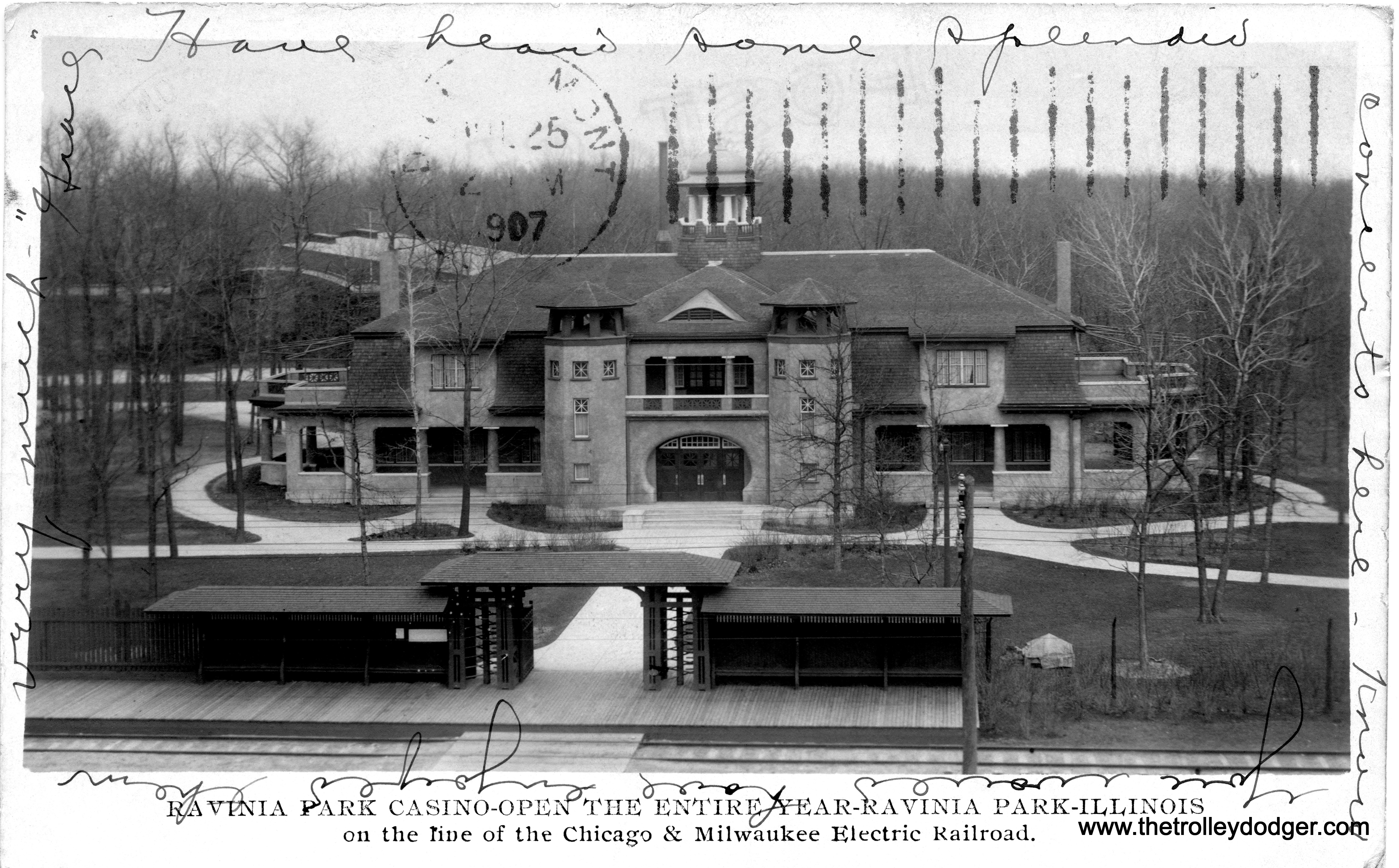
The Chicago North Shore and Milwaukee had its origins in Waukegan. Here, we see Chicago and Milwaukee Electric car #9 near a hospital in Waukegan. The picture dates to around 1907. Streetcar service continued in Waukegan until 1947.

North Shore Line cars 436, 404, and 161 are operating as a Milwaukee Business Man’s Special at 2nd and Grand in 1918. This was the end of the line prior to the opening of the interurban’s new terminal at 6th and Michigan in 1920.

On March 25, 1962, a Central Electric Railfans’ Association fantrip train has made a photo stop at 6th Street and Scott on the North Shore Line. This is where the interurban line made a jog from 5th to 6th, before heading north via street trackage to the terminal at 6th and Michigan. The fantrip train is the northbound one at left. A regular service train is southbound at right. Both cars are Silverliners. This is now the site of an expressway access road. Scanned from the original Anscochrome slide. (William C. Hoffman Photo)

A closeup of the previous picture. The fans have formed a photo line while a regular service train heads southbound.

The same location today. The two buildings at right appear to be the same ones in the 1962 picture. The North Shore Line tracks went in about the same location as where those autos are parked. Milwaukee’s freeways were built in stages, and the segment near here opened in 1968, about five years after the abandonment of the interurban.

The interior of North Shore Line car #154 on October 24, 1962. This car, built in 1915, became the oldest survivor in the fleet for many years, but it could not survive decades of neglect at a museum that did not take care of it. It has since been scrapped.

The interior of NSL 168.

One of the North Shore Line Electroliners, looking a bit rusty after nearly a year without being used, has arrived at the Red Arrow Lines (Philadelphia Suburban Transportation Company) 69th Street Yard on November 17, 1963. Notice the emblem on the front is missing, having been removed prior to transport. After being fitted with different third rail shoes, it was tested on the Norristown High-Speed Line. Additional modifications were necessary. The Shops transformed it into a Liberty Liner, and put it into service just about a year after the NSL abandonment.

North Shore Line pocket calendars from 1947 and 1948.


On January 4, 1963, North Shore Line car #162 is over an inspection pit and out of service at Waukegan. However, it survived the abandonment and with the scrapping of car 154 a few years ago, 162 became the oldest NSL car extant. (It was delivered ahead of 160.) Although it needs a lot of work, it is now at the East Troy Railroad Museum, where it is being restored.
More Recent Finds

CTA Chicago Transit Authority “L” 6000s (Train coming up from State Street Subway – view looks north)
Location: Chicago, Illinois (14th Street – South Side “L”)
Date: July 3, 1966
Photographer: William C. Hoffman
This is an unusual photo for 1966. Bill Hoffman took this picture while looking out the window of a fantrip train. There were no regular service trains on this stretch of the “L”from 1949 until 1969. In 1949, the CTA revised North-South service, and hereafter, all trains ran through the State Street Subway. This changed with the inauguration of the new Dan Ryan “L” in 1969. The Roosevelt Road “L” station was served only by North Shore Line trains from 1949 until 1963. With the abandonment of the NSL, the station was closed. This may be the fantrip that had a photo stop at the closed station shortly before it was demolished. A new station has since been put there.

CTA Chicago Transit Authority “L” Subway
Location: Chicago, Illinois (North and Clybourn Subway Station)
Date: August 22, 1966
Photographer: William C. Hoffman
This picture shows the CTA subway station at North and Clybourn, the only such subway station on the system built with an above-ground building entrance. This was part of the State Street Subway and opened in October 1943. In recent years, this station entrance has been renovated. But here, 23 years after opening, you can see how some of the lettering on the outside of the station has deteriorated. It was eventually removed. There was also a bus turnaround at the station which was eventually removed.

On December 11, 1955 (a Sunday) a fantrip train made up of CTA high-performance cars 6129 and 6130 has posed for a photo stop at Sedgwick. The signage is for the Shopper’s Special service, which was a mid-day version of the Evanston Express, which today only runs during weekday rush hours. There were other Shopper’s Specials on various lines dating back to the 1920s, but the Evanston one ran from November 28, 1955 until July 4, 1957. As late as the 1980s, though, the Evanston Express ran until nearly noon. These cars, built in 1950, were fitted with trolley poles for use on the Evanston Branch, which did not use third rail until 1973. They were fitted with experimental high-speed motors in 1955. These tests paved the way for faster rapid transit cars, such as the 2000-series starting in 1964. On Sundays, Ravenswood “L” service in 1955 did not operate south of Armitage at night or on Sundays. This was later changed to Belmont in the early 1960s, but with increased ridership, today’s Brown Line runs to the Loop during those times. (William C. Hoffman Photo)

On August 22, 1957, a six-car Evanston Express “L”train heads southbound at Franklin and Erie. The last wood cars on the CTA ran in regular service on November 30, 1957, on the Kenwood Branch. Numerous mid-to-late 1950s autos, some with tail fins, are also present. (William C. Hoffman Photo)

On August 30, 1959, when William C. Hoffman took this picture, the Chicago White Sox were in first place in the American League Pennant Race. The clinched a World Series berth by defeating the Cleveland Indians 4-2 on September 22nd, when Early Wynn won his 20th game of the season. The Pale Hose went on to lose the World Series to the Los Angeles Dodgers, four games to two. This shows the 35th Street station on the South Side “L”, looking to the east. The large crowds encountered during the ’59 Series helped inspire the CTA to renovate this station, which was then changed to a center island platform. Since the Dan Ryan “L” opened in 1969, closer to the ballparks (Comiskey Park was replaced after the 1990 season) most fans use that line instead of the South Side “L” (today’s Green Line).

TM Milwaukee Electric Trolley Streetcar #966
Location: North Chicago, Illinois (Illinois Railway Museum)
Date: June 30, 1962
Photographer: William C. Hoffman
Don’s Rail Photos: “966 was built by St Louis Car Company in 1927, (Job) #1466. It was purchased by Illinois Railway Museum in 1958.” A lightweight safety car, it is currently stored inoperable.

On July 29, 1955, William C. Hoffman captured this view of Chicago’s “L” looking east from the Chicago River along Van Buren Street. This leg of the “L” connected the Loop structure with the Metropolitan West Side Elevated, and was in use from 1897 to 1955. Market Street ran north and south here, but would soon be rebuilt into Upper and Lower Wacker Drive. The “L” was in the way, and soon, a new connection was built to relace this, running through the old Wells Street Terminal. This had last been used by the Chicago Aurora and Elgin in September 1953. By 1957, the structure running east from here to Wells Street had been removed. That’s a Garfield Park train navigating the curve. Notice also, the Van Buren Street bridge is being replaced by a newer one, under construction. I have previously seen this image online, in a lo-res version, but this has been scanned from the original Anscochrome slide in my collection.

After the opening of the Congress median line in June 1958, the “L” tracks leading to the old Wells Street Terminal were cut back to this point at Wacker Drive. On June 13, 1962, this is how it looked. The CTA used it to store maintenance equipment, and it appears there was a parking lot underneath part of it. All this was removed in 1964. (William C. Hoffman Photo)

This is an early Ektachrome slide that has shifted to red, due to unstable dyes in the other colors. In many instances, we are able to color-correct these using computer technology. But in this case it wasn’t very successful, so we presented it as a black-and-white image instead. Kodak reformulated Ektachrome in 1963, and solved the problem of the unstable dyes.

Here we see how a new connection was being built bridging the old Wells Street Terminal and the Loop “L” on June 5, 1955. The now-unused platforms were cut back as needed to create room for tracks that would curve in and out of the Loop. Once the top of the building facade was removed, new steel was added. The new connection, including Tower 22, went into service on October 11, 1955. (William C. Hoffman Photo)

This picture was also taken on June 5, 1955 by William C. Hoffman.

On June 21, 1956, a Garfield Park “L” train made up of 4000-series cars is turning from the Loop onto what had once been the Wells Street Terminal. This new very short track connection was put into place to allow for the demolition of a much larger stretch of “L” structure along Van Buren and what had once been Market Street, but was now becoming Wacker Drive. Behind the train, but almost entirely out of view, Tower 22 controlled these movements. The Loop “L” was uni-directional (counterclockwise) from 1913 to 1969, so this train was southbound prior to making this turn. Photographer William C. Hoffman took this picture to show how part of the platform had to be cut out to allow for the swing of the cars while switching. This arrangement continued through June 21, 1958, two years to the day after this picture was taken. In the distance, you can see Tower 8 at the intersection of Van Buren and Wells, which had previously handled switching at the old connection point. The clock tower belongs to Grand Central Station (1890-1971), located at Harrison and Wells.

The crane seen in the distance in this July 29, 1964 view of the former Wells Street Terminal would suggest that demolition is underway. The terminal went through several distinct phases. From 1905 to 1927, it was in its original configuration– a stub end terminal, not connected to the Loop directly at this point. It was renovated in 1927, with the addition of an attractive second-story facade and improved facilities. The CTA stopped using it in 1951, and the CA&E in 1953. In 1955, the facade was removed in favor of a new direct track connection to the Loop “L”, replacing the former connection via Van Buren Street. Tower 22 controlled the movements of Garfield Park trains in and out of the Loop. This continued until the new Congress median line replaced Garfield in 1958. Soon cut back to Wacker Drive, these tracks were only used for storage. By the time this picture was taken, there was only one track leading to the Loop instead of two. And soon after William C. Hoffman took this picture, looking from the nearby Quincy and Wells station, the rest of it would soon be gone.


By August 19, 1964, further work had been done dismantling and removing the old Wells Street Terminal tracks and structure. Now, the platforms are gone, and you can see the electrical substation the “L” had once gone over. (William C. Hoffman Photo)

CTA Chicago Transit Authority “L” 6000s (8-car train)
Location: Chicago, Illinois (Looking south from 33rd Street – South Side “L”)
Date: July 17, 1961
Photographer: William C. Hoffman
The Chicago Transit Authority closed the 33rd Street station in 1949, as part of their rationalization of North-South “L” service in order to speed up service. A walkway connected with the 35th Street station, which had side platforms, for use by exiting students from the Illinois Institute of Technology. Riders could exit through the old 33rd station.
After large crowds used the 35th Street station during the 1959 World Series, where the Chicago White Sox lost to the Los Angeles Dodgers, four games to two, the CTA decided to redo this station with a center island platform. This new station opened in June 1961. The northbound platform, although unused, was retained for a few months because it connected to the walkway, which closed on September 25, 1961.
So, this picture was taken after the new center island platform had opened, but before the walkway to 33rd was closed. You can’t see the walkway in this picture, as it was on the opposite side of the “L” structure.
The new 35th Street station was only in use for just over one year when it was destroyed by fire on October 17, 1961. It had to be rebuilt yet again. Eventually, the old station at 33rd Street was removed.

By July 18, 1963, the Chicago Transit Authority had already removed the Clark Street entrance to the old North Water Terminal which ran over Carroll Street, where freight once ran all the way to Navy Pier. This stub-end terminal dated back to the earliest days of the Northwestern Elevated at the turn of the century, but the last CTA trains ran there in 1949. It was a useful place for special runs, like the 1950 introduction of the North Shore Line’s Silverliners, but at some point it was taken out of service completely. It was torn down the following year, when the CTA demolished a lot of unused structure and presumably made bank on the resulting scrap value. (William C. Hoffman Photo)


When the CTA wanted to extend the northbound platform at the Merchandise Mart “L” station, the tracks leading to the North Water Terminal were in the way. So they came up with a creative solution– a movable platform that could slide out of the way if needed. On August 19, 1964, William C. Hoffman took this picture showing how the track connection to the stub-end terminal had been cut. Soon the entire terminal would be demolished, as were several other “L” structures that were no longer in use. Perhaps this was motivated by the cost of scrap, or a reduction in the expenses of having to maintain things.

William C. Hoffman took this picture of the CTA’s North Water Terminal being dismantled on September 23, 1964, looking west along Carroll Avenue from Clark Street. The tracks below are from the Chicago and North Western freight line that ran to Navy Pier.

CTA 6000s in old colors (right) and new colors (left) at Damen, Milwaukee and North Avenue in January 1970. We are looking northwest. (Jeffrey L. Wien Photo)

Here’s how the Red Arrow Lines terminal looked on a July 1963 night at the 69th Street Transportation Center in Upper Darby, just outside Philadelphia. Car #12, a double ender that has PCC car styling (but was technically not considered such) is signed for the Ardmore line. Ardmore trolleys were replaced by buses at the end of 1966. Riders can change here for the Market-Frankford elevated to go to downtown Philadelphia. The Red Arrow suburban trolley lines to Media and Sharon Hill continue today under SEPTA, a public agency. The ghostlike blue blur means the photographer took this picture using a long exposure, and someone moved while the shutter was open.

The last night of service on the Myrtle Avenue Elevated in Brooklyn. This line opened in 1888. While a small portion of this line is still in use, much of it closed on October 4, 1969. It was the last line in New York City that used wooden rapid transit cars. This was nearly 12 years after the last woods ran in Chicago, on the Kenwood “L”. The Myrtle Avenue El structure wasn’t sturdy enough to handle heavier rapid transit cars, which is why it was abandoned.

On August 23, 1954, we see the body of an old red Chicago streetcar being used as a lunchstand on the southeast corner of 33rd and Ashland. This was from the 1101-1423 series built by the St. Louis Car Company in 1903 and 1906– the same as #1374 at the Illinois Railway Museum, the “Matchbox.” This is also known as a Small St. Louis Car. These were retired in 1946 when the new postwar PCC cars started to come in. There was an empty lot here in 2019, but a new building has gone up since. (William C. Hoffman Photo)

On July 28, 1957, construction was already underway in suburban Oak Park on the new Congress expressway (Now Eisenhower). We see a retaining wall at left, indicating an excavation. At right, new tracks are being installed, including a crossover. The location is just west of Oak Park Avenue. This would become the new location where the B&OCT tracks and the CTA would cross each other. Soon, the CTA tracks would be moved to the north, and the Baltimore and Ohio Chicago Terminal would also move north, occupying what had been the CTA right-of-way. Once the south end of the highway footprint got excavated, both sets of tracks were put there, and then the rest of the highway was completed. This view looks west, and we can see the Forest Park gas holder in the distance, located just east of First Avenue. (William C. Hoffman Photo)

On September 8, 1957, a westbound two-car CTA Garfield Park “L” train approaches the new temporary station, while photographer William C. Hoffman looks to the east from the old station. Graham Garfield (from chicago-l.org): “Work on the Congress Expressway and “L” line west of Laramie Avenue resulted in some complicated staging and several temporary facilities along the at-grade portion of the Garfield Line. On September 6, 1957, westbound Garfield Line trains shifted to a set of temporary tracks from Austin to west of Oak Park, north than the previous alignment. Concurrent with the move to the temporary alignment west of Austin, a temporary island platform was opened on east side of Oak Park Avenue for westbound trains and the old westbound side platform on the west side of Oak Park Avenue was closed. Eastbound trains followed onto the temporary alignment and began using the temporary island platform on September 17, closing the old eastbound side platform and station house on the east side of Oak Park Avenue.” Eventually, the Baltimore and Ohio Chicago Terminal trains were shifted north onto what had formerly been the CTA’s tracks. This is now the site of the Eisenhower expressway, where it is below grade. This section of highway opened in October 1960.


This picture was taken at the same location as the first one in the next section, but there is a world of difference. A six-car train of CTA wood cars has turned off the four-track Metropolitan Main Line to head south on the Douglas Park “L”. This was taken on April 1, 1954, which the photographer indicated was the last day of operations on the old structure. Garfield Park “L” trains had last run here in September 1953, before being shifted onto a temporary right-of-way in Van Buren Street. Now, new connections (visible here at right) were built for Douglas trains– first, to take them across the Congress expressway footprint, then connect up with part of the old “L” going to Logan Square and Humboldt Park, and finally, to a new connection with the Lake Street “L” for the trip downtown. This permitted the demolition of the remaining portions of the Met “L” structure that were in the path of the new highway. The tracks west of here had already been removed. This new route for Douglas continued in use until June 22, 1958, when the new Congress median line opened here. But decades later, it once again became the route for the Pink Line, successor to the Douglas service. (William C. Hoffman Photo)
Chicago Aurora and Elgin

On July 21, 1950, an inbound Chicago Aurora and Elgin train, led by car #48, approaches the Marshfield “L” station, while a CTA Garfield Park train trails behind. This was the junction of all the Met lines– Douglas Park, Garfield Park, Logan Square, and Humboldt Park. Douglas trains used the tracks here at left. Outbound CA&E trains could pick up passengers at the platform on the right. The tracks leading to the northwest side were just out of view to our right. Soon, practically all the buildings you see here would be removed, as construction of the long-awaited Congress expressway would soon be underway. Don’s Rail photos: “48 was built by Stephenson in 1903. It was modernized in January 1940 and retired in 1955.” (William C. Hoffman Photo)

This CA&E bus appears to date to the late 1920s– but where did it operate?

On August 13, 1950, an inbound two-car Chicago Aurora and Elgin train has just left the Lakewood station on the Elgin branch. This image was color-corrected from an Anscochrome slide that had shifted to red. (William C. Hoffman Photo)

This Anscochrome slide, now 75 years old, has shifted to red due to unstable dyes, much like early Ektachrome has. But I don’t think Ektachrome was introduced until 1955. The technology may be very similar, though, as both films were based on Agfa technology.

On August 13, 1950, CA&E car #315 is at Wheaton. This original Anscochrome slide was so badly faded and shifted to red that it was not possible to fully color-correct. This car was not actually purple with cyan ends. Parts of the image have too much green and too much magenta at the same time. Those colors are opposites, so not matter which way you try to change the color, it’s not going to look right. It’s still a big improvement on the original (see below). (William C. Hoffman Photo)


The same considerations apply to this Anscochrome image from August 13, 1950 at Wheaton. It was not possible to fully restore the color. The grass looks right but the car was blue, not purple. (William C. Hoffman Photo)


This circa 1909 real photo postcard image produced some controversy online regarding its location. But the only place it can possibly be is the Batavia Terminal, which originally had two tracks and third rail. The Great Third Rail, the famous CERA publication, says third rail was replaced by overhead wire here in the 1930s. The second track was most likely removed as the light ridership on this branch made it unnecessary. Generally service was operated by a single shuttle car, going back and forth to Batavia Junction, where passengers could change to Aurora branch trains. An early timetable indicates there had once been direct service downtown. Even the terminal building was altered over time, as the canopy was removed.

Here’s how the Batavia Terminal looked in later days.

Once the CA&E and the Chicago Rapid Transit Company ended their joint funeral train service in 1934, the interurban’s trackage along Roosevelt Road west of Mannheim in Hillside was cut back to Oak Ridge, adjacent to the Oak Ridge Cemetery. On May 19, 1957, we see CA&E wood car #309 on a fantrip. This branch had many names, including Cook County and Mt. Carmel, but unlike the other CA&E sections, it did not have any third rail. The man in the raincoat may in fact be William C. Hoffman, who took several of the other photos in this post. (Vic Wagner Photo)

Not all the rails were pulled up on the Mt. Carmel branch. Here at Oak Ridge Avenue, some were simply covered over with dirt.

The same location in 2024. This view looks east. The CA&E tracks curved off to the left, following those power lines.

CA&E 421 heads up a westbound train at the Glen Ellyn stop. That’s the tower of the Glen Ellyn village hall at right. (Martin Brady Photo)

And here’s how it looks today. A parking lot, with the Illinois Prairie Path at right.

CA&E car #455 is at the end of the line in downtown Elgin, circa 1955-57. This is one of the ten curved-sided interurban cars that did not get saved after the abandonment. It was built by the St. Louis Car Company in 1945.

Like everyone else, the Chicago Transit Authority was caught off guard by the Chicago Aurora and Elgin’s sudden discontinuance of passenger service in the middle of the day on July 3, 1957. Thousands of downtown commuters had to scramble to find a way home that evening. A couple days later, the CTA posted this sign at some “L” stations. William C. Hoffman took this picture on July 10, 1957.

This press photo, showing CA&E cars 414, 308, and 418 at the Wheaton Yard, ran with a story dated November 7, 1957– four months after the abandonment of passenger service. The view looks to the southwest.

An October 26, 1958 outing, which ultimately ran with four cars, was the last major fantrip held on the CA&E. The final fantrip on December 7, 1958 was not well attended and it snowed that day. Here, fantrip attendees, including Aurora Mayor Paul Egan (who famously offered to put up his house for collateral in a failed attempt to keep the CA&E running the year before) are at the Wheaton Yards. This is one of those early Ektachrome slides that has shifted to red. It was not possible to correct the color completely back to normal. (William C. Hoffman Photo)


On June 30, 1962, Chicago Aurora and Elgin car #309 was a recent arrival at the Illinois Electric Railway Museum in North Chicago. Don’s Rail Photos: “309 was built by Hicks Locomotive Works in 1907. It was modernized in October 1941 and acquired by Illinois Railway Museum in 1962.” Prior to purchasing it, the museum raised funds from its members, calling this car the “jewel of the fleet.” (William C. Hoffman Photo)

Chicago Aurora and Elgin car 320 is at Mount Pleasant, Iowa on September 13, 1975. Don’s Rail Photos: “320 was built by Jewett Car Co in 1914. It was modernized at an unknown date and sold to Iowa Chapter NRHS in 1962. It was transferred to Midwest Electric Railway Museum in 1968.” By now, it has been in Iowa longer than it ever was in Illinois. (William C. Hoffman Photo)
Keep those cards and letters coming in, folks!
-David Sadowski
Help Support The Trolley Dodger
This is our 317th post, and we are gradually creating a body of work and an online resource for the benefit of all railfans, everywhere. To date, we have received over 1,227,000 page views, for which we are very grateful.
You can help us continue our original transit research by checking out the fine products in our Online Store.
As we have said before, “If you buy here, we will be here.”
We thank you for your support.
DONATIONS
In order to continue giving you the kinds of historic railroad images that you have come to expect from The Trolley Dodger, we need your help and support. It costs money to maintain this website, and to do the sort of historic research that is our specialty.
Your financial contributions help make this web site better, and are greatly appreciated.


Copyrights
There is a popular impression that everything on the Internet is free, and that people can do whatever they want with the content. This is mistaken.
A lot of hard work goes into creating these posts. Everything you see here is my copyrighted work, and should not be reused without obtaining my permission. A scanner is a camera, and even in those cases where the copyright on what is being scanned may be in the public domain, the person who pushes the button to create that scan owns the copyright on the scan.
For example, if you went to the Art Institute and took a picture of Grant Wood’s American Gothic painting, you would not own the copyright to that. But you would own the photo itself and should have the rights to control what happens to your own photographs, no matter what the subject matter is. Someone else can take a picture of American Gothic and they would have control over what happens to their picture.
In addition, we have had additional creative input in using software such as Photoshop to interpret photos, slides, and negatives. These are derivative works and as I have exercised my creative input into how they look, regarding cropping, color, density, and restoration, they are also subject to copyright for those reasons.
This is similar to how a musician interprets a musical score. The score is created by the composer, and they own the copyright to it, but when someone plays the music, they put their own spin on it, and they have rights to what happens to a recording of it.
Please ask before reusing any of the images you see here. Proper credit must be given to both me and the original photographer, and any captions you see here should be included. You do not have permission to change or colorize any black-and-white images from the Trolley Dodger.
Under current copyright law, copyright exists without any registration or notice of same. Please be respectful of other people’s rights.
Thanks.


