

CSL 5249 appears to be heading southbound on Larrabee, just north of Chicago Avenue. To the left, you see the Montgomery Ward complex, which has since been turned into residential. 5249 is signed to go to Vincennes and 88th, which probably makes this a Halsted car. (Joe L. Diaz Photo) M. E. writes: “The barn at 88th and Vincennes was originally the barn for the Kanakakee cars that ran from the Englewood L station at 63rd Place and Halsted, south on Halsted, southwest on Summit (a short street connecting Halsted with Vincennes), and Vincennes. When that service folded, the Chicago Surface Lines took over the barn. That barn closed early in my lifetime.”
Today’s post features many “old school” railfan photos, all from the collections of William Shapotkin. In the 1930s and 40s, photographers such as Joe L. Diaz and Edward Frank, Jr. wandered all over Chicagoland, taking black and white photos of streetcars, “L” cars, and interurbans, which they printed up and sold at railfan meetings.
They were still selling these photos into the 1980s and 90s. Years ago, I met both of these gentlemen, who are sadly no longer with us. Perhaps the late Malcolm D. McCarter was the last of this breed. He started selling photos around 1942, and continued to do so for the next 75 years or so. He was also the last living original member of the Illinois Railway Museum.
Unfortunately, these photos often did not come with any documentation as to when, or where, these pictures were taken. We have written captions that include whatever we could determine. But I know that our highly informed, eagle-eyed readers will help us fill in some of the missing details.
When referring to individual photos, please use the file name (i.e. shapotkin262), which you can get by hovering your mouse over the image, instead of saying “the sixth photo down” or some such. We thank you in advance for helping us with these, and let’s thank Bill Shapotkin again for graciously sharing them with us.
You also might want to consider a trip to Indianapolis to attend this year’s Hoosier Traction Meet, which Mr. Shapotkin runs. You can view a flyer (in PDF form) with all the relevant information here.
-David Sadowski
PS- At the end of this post, you will also find a blurb for our upcoming book Chicago’s Lost “L”s, to be released on July 12 from Arcadia Publishing. So far, we have received orders for more than 70 copies, for which we are very grateful.
FYI, we also have a Facebook auxiliary for the Trolley Dodger, which currently has 368 members.
From the Collections of William Shapotkin

CSL Pullman 172. Daniel Joseph has identified this as the intersection of Ogden, Cermak, and Springfield.

CSL 5638, signed for Navy Pier, may be running on the Stony Island route. M. E. writes, “The caption is undoubtedly correct that these are Stony Island cars that had the
north destination Navy Pier. I’d like to add that I see so many trolley poles on the cars, going in both directions, that I think this place was the south terminal which was just north of 93rd St. South of 93rd St., the tracks were used for only a short distance by 93rd/95th St. cars.”

CSL 2803 is southbound on Ashland. (Joe L. Diaz Photo)

This picture, taken on April 12, 1915, shows some window damage to CSL car 6063.

CSL 6101, signed for 35th Street. Chris Cole says this “appears to be taken at the Cottage Grove car barn at 38th Street. The Ida B Welles public housing project 2 story buildings are in the background. The Wells Homes ran from Cottage Grove to King Drive and 35th to Pershing Rd (39th). I also note that there are a number of overhead lines that would be present on the driveway to the barn. I believe that the 35th streetcar used the Cottage Grove barn from 1946 to 1951.”

CSL 2601 on the 111th Street line. (Joe L. Diaz Photo)

CSL 1455. (Joe L. Diaz Photo)

CSL 2745. (Joe L. Diaz Photo) Andre Kristopans says this is “looking W down Wrightwood from Lincoln on Lincoln Carhouse leads – car is pulling out to do a Riverview-Larrabee run.” Daniel Joseph adds, “Possibly at Wrightwood, Lincoln & Sheffield at car barn.”

CSL 2599 on the Brandon-Brainard line. (Joe L. Diaz Photo)

CSL 419 at the east end of the Chicago Avenue line on December 27, 1946.

CSL 5653, signed for Ashland. (Joe L. Diaz Photo)

CSL 2730 and 2728. (Joe L. Diaz Photo) Andre Kristopans: “Open yard on west side of Lincoln carhouse looking south.”

CSL 2731 and 1346. (Joe L. Diaz Photo) Andre Kristopans: “Open yard on west side of Lincoln carhouse looking south.”

CSL 3315 on the 67-69-71 route.

CSL 5154.

CSL 5702, signed for 93rd and Stony Island. Our resident south side expert M. E. writes: “I’m going to hazard a guess as to where this picture was taken. But first, I present my case. The destination sign on the first car says “Stony Island-93rd”; the sign on the second car says (I think) “Stony Island-Downtown” — yet both cars are on the same track, heading in the same direction. Why would that happen? It might happen if these were special fan trips, one car following the other, oblivious to their destination signs. Or it might simply be two Stony Island cars heading to 93rd St., but the sign on the second car is wrong. Another factor to consider is that the tracks on Stony Island ran in the street
south to 69th St., but south of 69th, they had their own right-of-way between the north- and south-bound auto traffic lanes. In this picture, I believe I see a separation between the tracks and the car lane. Therefore this picture was taken south of 69th St. But the best clue, by far, is the round sign in the distance: “Ruby OK used cars.” The dealership was Ruby Chevrolet. I went to Google and looked up “ruby chevrolet used car location south side chicago”. Up came a link to a Tribune obituary about Richard Ruby, car dealer and attorney, dated 8 December 2014. In that obituary, it says Ruby’s lot was at 72nd and Stony Island. Next, consider the railroad crossing sign. It is a dinky sign with no flashing lights. That would indicate a crossing that was lightly used by trains. I submit that this is the trackage used by the Baltimore and Ohio railroad that started at about 71st and Dorchester (as an offshoot from the Illinois Central main line), then ran southeast, along the ground, through South Shore and to the South Chicago neighborhood. In Google maps, if you enter “73rd and Stony Island Chicago”, you will see the path used by that trackage. It crossed Stony Island just south of 73rd. (This railroad trackage lasted a long time, because the B&O did not want to give it up. So, every day at 3 p.m., they ran a diesel engine and caboose — maybe a few freight cars too — down that track. Motorists mostly ignored the rail crossing signs, so the train had to proceed very slowly and blow its horn constantly.) So, I think this photo’s location is the southeast corner of 73rd and Stony Island, looking north. North of 73rd, Stony Island tracks also carried South Deering cars, which ran from the Jackson Park L at 63rd and Dorchester, south to 64th, east to Stony Island, south to 73rd, then east on 73rd. In the photo, South Deering cars made the turn to the right, whereas Stony Island cars continued straight ahead. Gee, that was much fun to deduce!”
Andre Kristopans concurs: “Looking north on Stony at 73rd. RR crossing just out of picture to left was the old B&O Brookdale line, once the main line into Chicago.” Mitch Markovitz adds: “That’s my old neighborhood. Both cars southbound at 73rd and Stony with the tracks for South Deering branching off. It doesn’t really matter what the destination sign reads on the second car. Changing the sign won’t make the car stray off to distant lines. Either a pull out, a pull in, or someone futzing and changing the sign.”

CSL 5171.

CSL 5909 on Route 47.

CSL 1868. I can’t make out the destination sign. (Joe L. Diaz Photo) Michael Franklin: “This is the 5200 block of Harrison St, Chicago. Buildings are still there.”

CSL 419, at the east end of the Chicago Avenue line on December 27, 1946.

CSL snow sweeper E1. Don’s Rail Photos: “E1, sweeper, was built by Lewis and Fowler in 1895 as Chicago Rys 2. It was renumbered E1 in 1913 and became CSL E1 in 1914. It was retired on November 24, 1950.” (Joe L. Diaz Photo)

Not sure which CTA snow plow this is. (Joe L. Diaz Photo) Bill Wasik says this “shows an eastbound snowplow on 92nd St. as it approaches Baltimore Avenue. Can’t identify the plow, but two buildings of note in this photo are still standing. These include the glass-bricked neo-Romanesque banquet hall at the far right. This is an 1891 corner block at the northwest corner of Baltimore Ave. Also visible one block to the west is a bank building that once was the headquarters of the Steel City National Bank, a facility mired in scandal during the early 1970s.”

CSL/CTA salt car AA10. Don’s Rail Photos: “AA10, salt car, was built by CUT in 1899 as CUT 4492. It was rebuilt as 1445 in 1911 and became CSL 1445 in 1914. It was rebuilt as (a) salt car in 1930 and renumbered AA10 on October 1, 1941. It was retired on February 18, 1955.”

CSL 3307 is westbound on Montrose, about to cross under the Chicago & North Western railroad at about 1800 West.

The Chicago Surface Lines tracks were extended to the site of A Century of Progress in 1933. This could be from that year, as a shelter is under construction. We are looking south.

CSL 840 under the “L”. (Joe L. Diaz Photo)

CSL 5621, signed to go to Belmont and Clybourn. This picture seems to date to the mid-1930s.

CSL 204. (Joe L. Diaz Photo)

A Chicago Surface Lines trolley bus on Route 86 – Narragansett. This route used trolley buses from 1930 to 1953.

Chicago Motor Coach Company double-decker bus 500, built in 1923.

Andre Kritsopans: “Looking west towards east end of “east house” at 77th, basically where Wentworth south of 77th would be. 77th until 1970s had two separate buildings, with an open area between them, until the open area was roofed over. The pile of junk in front is 77th scrap pile, looks like mostly boilers and other building parts.”

CSL 3286. Might this be Kedzie Station (car house)? (Joe L. Diaz Photo)

On April 16, 1946, Mrs. Edith Sands and her family were living in the body of former CSL streetcar 1384. There was a housing shortage once WWII ended. There is a different picture of the interior of this makeshift home in our book Chicago Trolleys.

CSL 3296 is on Montrose. Could this be westbound at Welles Park? Note the Packard at left.

CSL 1415 is on Racine at Belden on July 9, 1946.
While researching the above photo, I ran across another one, taken at the same location but from the opposite direction:

CSL 1415, built originally in 1906, is at work on Racine at Belden on the WEBSTER RACINE route. The photographer is unknown. An original Kodachrome from February 1942. (John F. Bromley Collection)

CSL 5241 is southbound on Through Route 8, Halsted. Bill Shapotkin adds, “The car (signed for destination of 111/Sacramento and probably a school tripper for Morgan Park High School) is standing W/B in 111th St JUST EAST of Vincennes Ave. That house with the distinctive roof (left) still-stands today. View looks east.”

CSL 5436 is westbound on 79th Street at Ashland on June 11, 1948.

CSL 5635 at Navy Pier.

CTA 310.

I assume that CTA PCC 4300 is turning from Archer onto Clark, running a northbound trip on Route 42 – Halsted-Downtown, and that we are looking to the southwest. Note the Rock Island train in the background. Metra Rock Island District trains still use these tracks.

The same location today.

Postwar PCC 4233 being delivered from Pullman.

Miles Beitler writes: “I searched the listings for the auto service garage on the right side of the photo. I found a listing for “Ragalie Bros. Auto Service” with a location of 3939 West 5th Avenue, a diagonal street. 3939 is at the intersection of 5th Avenue and Harrison Street. When I checked the 1932 telephone book I found (a) listing for Micheli Restaurant. That location — 3953 West Harrison — is also near the intersection of Harrison and 5th Avenue and it does seem to fit the photo. Moreover, I believe there was a streetcar line on 5th Avenue which ended at Harrison. Of course, the expressway was not there in 1932. Also note the horse drawn Bowman Dairy wagon on the right. I believe that Bowman Dairy used horse drawn delivery wagons well into the 1920s.”
A note re: the picture above. The addresses of the businesses and locations of buildings would seem to confirm that this is Fifth Avenue, just east of Pulaski Road, with Harrison Street as the cross-street in the background. The tracks that end in the middle of the street were for the Madison-Fifth line. When CSL introduced the new single-ended Peter Witts in 1929, they were used on Madison, and a loop was apparently devised for Madison-Fifth by extending these tracks around the block, via Pulaski and Harrison, to form a triangular-shaped loop. The new northbound track on Pulaski was separate from the existing streetcar tracks, so as not to interfere with Pulaski service. In late 1936, CSL put PCC cars on Madison, and these were also used on Madison-Fifth.
This branch line was discontinued on February 22, 1954, when construction of the nearby Congress Expressway reached this area, just to the north. Fifth Avenue was not a major street and would have required a complicated bridge over the highway, crossing at an angle. So it was decided to truncate Fifth instead.
The Garfield Park “L” ran east and west at this point, just south of the alley mid-block between Harrison and Flournoy Streets. The “L” would have been just out of view to the right of this picture. It intersected with Fifth Avenue at Pulaski Road, just behind the photographer.

In this zoomed-in view of the previous picture, the building in the distance matches the building in the next picture, taken in 1953.

CTA 1725 is operating as a one-man shuttle car on the Madison-Fifth branch line on Route 20 on February 15, 1953. The car is heading southwest on Fifth Avenue approaching Harrison Street and Pulaski Avenue, which was the end of the line near the adjacent Garfield Park “L” station. I thought at first that the date might actually have been 1954, but subsequent research shows the 1953 date to be correct. (Robert Selle Photo)
In addition, this photo, taken from the Pulaski Road station on the Garfield Park “L” station, shows buildings on the north side of Fifth Avenue that match up with those in the shapotkin308 image above. Note it’s the same exact fire escape:

On Sunday, September 13, 1953, CTA one-man shuttle car 3175 is on Fifth Avenue at Pulaski (Crawford), the west end of the Fifth Avenue line. This had been a branch line from route 20 – Madison. From this point, the cars looped via Pulaski and Harrison before going back NE on Fifth. The photographer was on the Garfield Park “L” at Pulaski. The “L” was heading east and west at this point, just south of where the Eisenhower expressway is today. This “L” station remained in use until June 1958. Streetcar service on Fifth Avenue continued into early 1954. The Fifth Avenue line used gauntlet track on Pulaski, so as not to interfere with Pulaski streetcars. This is confirmed by studying the 1948 supervisor’s track map. Danny Joseph adds, “As a child I lived near this triangle when both Pulaski and Fifth still operated street cars and Harrison did not. I was very fascinated by the gauntlet on Pulaski which was the first time I saw such construction.” (Bob Selle Photo)
The gas stations on the triangular-shaped corner of Harrison and Fifth also match, between the late 1920s photo and this one from 1950:

This birds-eye view of CTA 1744 was taken from the Pulaski Road “L” station on the Garfield Park branch in April 1950. However, what we are looking at may actually be a Madison-Fifth car at the west end of its route, ready to loop back via Pulaski and Harrison. Bill Shapotkin adds, “This image is looking E-N/E on Fifth Ave from the Garfield Pk ‘L’…no question about it. The intersection behind the streetcar is Harrison.”
Now that we have determined where shapotkin308 was taken, it’s the presence of a late 1920s Franklin automobile that pins the date down to circa 1926-28. In 1929, the streetcar tracks on Fifth Avenue were extended around the block. Interestingly, the Franklin used an air-cooled engine, and the radiator grill on the car was simply for show. After the Franklin firm failed in 1934, it was succeeded by Aircooled Motors, which was later purchased by Preston Tucker, and provided the engines (water-cooled) for the short-lived 1948 Tucker Torpedo. Aircooled Motors survived Tucker and continued in operation until 1975, providing engines for many small airplanes and helicoptors.


CTA 6002 is southbound on Kedzie on June 22, 1950, having just passed the Garfield Park “L”. Service at this station continued until June, 1958, since it was not in the path of the Congress Expressway.

The same location today.

CSL 5656.

This could be the west end of the 75th Street route. CSL Pullmans 122, 126, and 392 are visible. (Joe L. Diaz Photo)

This photo has a lot of scratches, but it does show CSL 2510 at 75th and the lakefront. Presumably the negative was scratched from being printed many times. (M. D. McCarter Photo)

CSL 5993, on the 31st Street route, is running direct to the World’s Fair (A Century of Progress), so this must be 1933-34. (Edward Frank, Jr. Photo)

CSL 6103 is running on Through Route 17 – Kedzie. (Edward Frank, Jr. Photo) Daniel Joseph: “Probably Kedzie & 30th St looking north at grade crossing.”

CSL 1942 is signed for Chicago Avenue. (Joe L. Diaz Photo)

CSL 1466. This may be one of the cars that was usually used to train crews in the Van Buren Street tunnel under the Chicago River. (Joe L. Diaz Photo) Daniel Joseph says, “I believe this is at 18th St, Canalport & Normal.”

CSL 3216 is signed for 51st and Central Park. M. E. writes: “Given that the destination sign reads “51 – Central Park”, then this picture was taken from the northwest corner of 51st and Cottage Grove Ave., looking south. The 51st St. line’s eastern terminal was actually at 55th St. and the Illinois Central railroad at Lake Park Ave. From there, the route headed west on 55th to Cottage Grove Ave., north to 51st St., and west on 51st St. So the car in this picture is making the turn from northbound Cottage Grove to westbound 51st.” On the other hand, Graham Garfield writes, “Note the sign on the light pole that says “4A”. Illinois route 4A was a state highway from Joliet to downtown Chicago via Archer Ave. until 1967. Based on buildings in the background that are still extant, the angled street here is Archer and the car is deadheading from Archer carbarn (where the #51 was out of) to 51st St to start its run. We are looking northeast at Archer/Kedzie.”

CTA 5444 is one of two cars at Racine and 87th Street. (Joe L. Diaz Photo)

CSL 3091 is signed for Elston and Lawrence. (Edward Frank, Jr. Photo)

CSL 3319, southbound on Damen. (Joe L. Diaz Photo) Daniel Joseph writes, “Probably Damen & 59th looking north at viaduct on the 5800 block.”

CSL 133 is signed for 75th and Lake Park. (Joe L. Diaz Photo) Daniel Joseph adds, “Probably 75th & Constance at the now abandoned B & O crossing.”

CSL 3010 is signed for Elston-Downtown. Bill Wasik adds, “Shapotkin 294 shows the 4700 block of Elston Ave. looking north toward Lawrence Ave. The photo likely was taken in 1946-47. The large three-story commercial building seen in the distance behind the Drewrys billboard was part of the Bankers Life complex. Demolished in the 1990s, it was replaced by an apartment complex for seniors. Most of the other buildings in this scene are still standing.”

CSL 2619 is on the Brandon-Brainard line on the far reaches of Chicago’s south side. (Joe L. Diaz Photo)

CSL 3303 is eastbound on Montrose, having just crossed under the Chicago & North Western and the Ravenswood “L”.

CSL 498 and 3085. I am unable to see the route signs, but at least we can tell this picture was taken in the 34th Ward. 498 is signed to go to North Western Station, which was a sign used on Milwaukee Avenue cars. Michael Franklin says we are “looking at the NW corner of Armitage & California.”

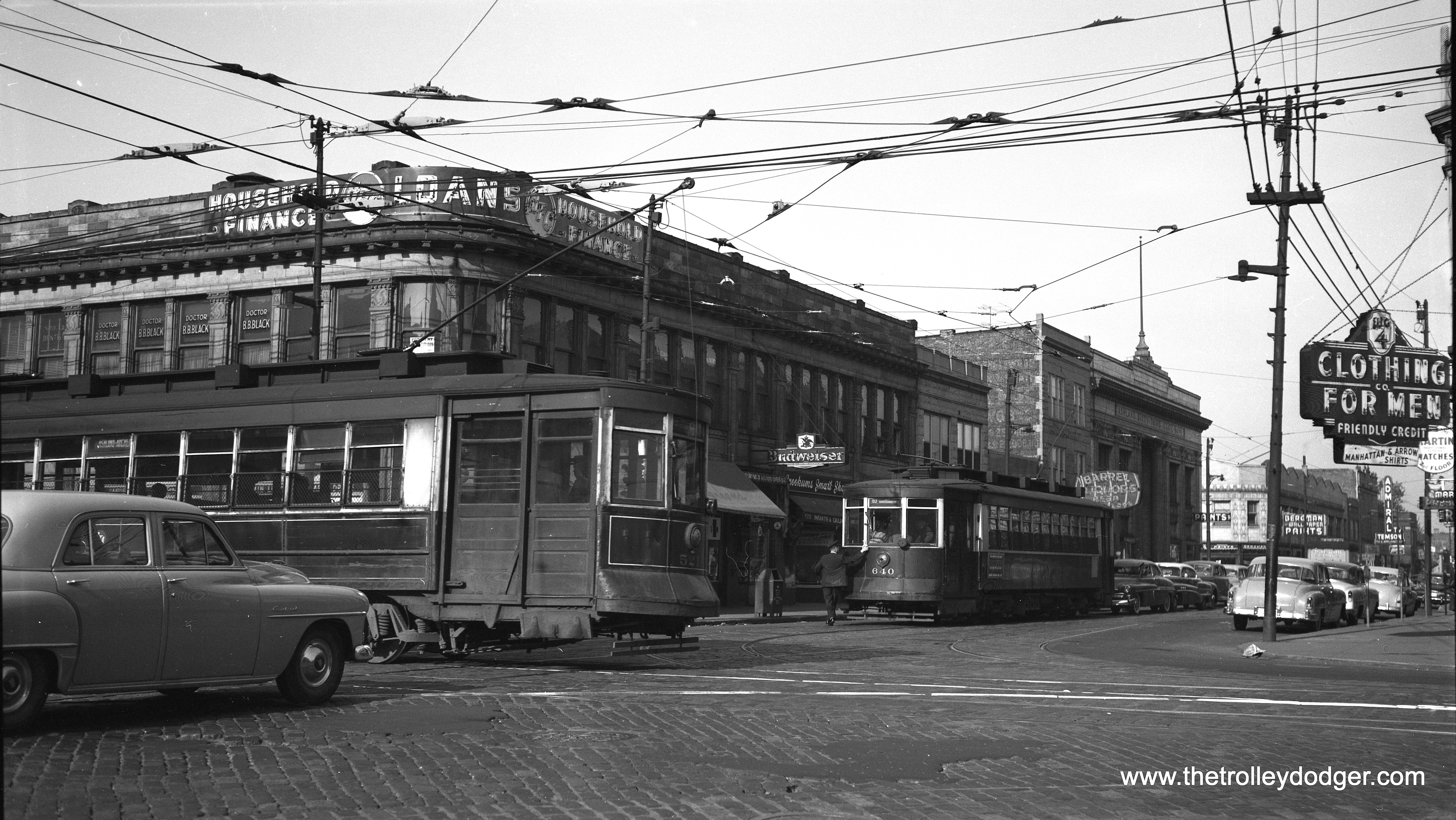
CSL 5505 is on Through Route 8, (Halsted) signed to run to Vincennes and 88th. (Joe L. Diaz Photo) Bill Shapotkin adds: “Car #5505, working a S/B trip on Chicago Surface Lines (CSL — a CTA predecessor) Rt #8 — HALSTED is seen turning from E/B Division into S/B Crosby St on Chicago’s North Side in this undated photo. View looks N/W. Normally cars would operate in Halsted all the way from Waveland Ave (3700 North) south to 86th St (as the south end-of-line was until December 4, 1949, 111th/Sacramento). Over the years, the moveable bridge over the North Branch of the Chicago River was out-of-service for repairs. Any time that happened, HALSTED cars (and later buses) detoured around the out-of-service bridge by operating E/B Division-S/B Crosby-Larrabee-W/B Chicago (or the reverse for N/B cars or buses). This car is taking that long-standing detour. The matter of the cantankerous bridge was finally resolved when it was replaced by a fixed (i.e.: non-moveable) bridge — believe in the 1990s. My sincerest thanks to Andre Kristopans, who assisted in identifying the photo location.”

CSL 2595 is on the 87th Street route, possibly prior to the extension of this line in 1937, which was the final streetcar extension in Chicago.

CSL 5083 is signed for Pitney and Archer. (Joe L. Diaz Photo)

CSL 5130, signed for 31st and Lake Park, appears to be eastbound on 31st, having just passed the South Side “L”. (Joe L. Diaz Photo)

CSL 927.

CSL 1145. (Robert W. Gibson Photo)

CTA snow plow E-207. (Joe L. Diaz Photo)

This is actually a picture of CTA 225 at Dearborn and Kinzie, on a December 18, 1955 fantrip, where it was disguised as 144 with a piece of oilcloth. The story goes that Maury Klebolt, who organized this trip, had advertised that car 144 would be used, and for some reason, it was not available that day. 225 was later sold to the Seashore Trolley Museum, where it remains today, while 144 is at the Illinois Railway Museum.

CTA 225 at Clark and Cermak on a February 16, 1957 Central Electric Railfans’ Association fantrip.

CTA 144 at 81st and Emerald on the final Chicago streetcar fantrip on June 15, 1958.

Chicago Aurora & Elgin wood car 318. Don’s Rail Photos: “318 was built by Jewett Car Co in 1914. It had steel sheating and was modernized in 1944. It was sold to Wisconsin Electric Railway Historical Society in 1962. It was wrecked in transit and the parts were sold to IRM to restore 321.” (Joe L. Diaz Photo)

CA&E 10. Don’s Rail Photos: “10 was built by Niles Car in 1902. It was rebuilt with a baggage compartment in 1910. It was later removed, but then reinstalled in April 1933 for funeral service. It was wrecked September 10, 1948, and scrapped.” (Joe L. Diaz Photo)

CA&E 455 at the front of a Chicago Limited. Not sure what the workers at left are doing.

CA&E electric loco 2002 is at left. I can’t make out the numbers on the steel cars at left.

CA&E 48 at left, with 315 at right. Can this be Wheaton? Don’s Rail Photos: “315 was built by Kuhlman Car Co in 1909, #404. It was modernized at an unknown date and sold to Rockhill Trolley Museum in 1962.” (Joe L. Diaz Photo)

CA&E 320 at an unknown location. (Joe L. Diaz Photo)

CA&E 410 heads up a two-car train in Wheaton.

CA&E 409 at the Wheaton Shops.

CA&E 452 leads an Aurora-Batavia Limited.

Not sure where this is. Could it be Wheaton? Dann Chamberlin: “Yes, it is. The Wheaton yard and shops are to the rear of the photographer. The photo looks east towards downtown Wheaton. Note the tower of the DuPage County courthouse in the right-rear of the photo.”

CA&E 458 heads up a Wheaton local. Not sure where this is. Dann Chamberlin: “The train has just left the Main Street Glen Ellyn stop headed west towards Wheaton. The Main Street gate tower can be seen in the left-rear of the photo. To the right of 458 one can make out the tower of today’s Glen Ellyn Civic Center. I attended junior high school in that building!”

CA&E 459 at the front of a two-car train. Could this be Wheaton? Dann Chamberlin: “Again, yes it is. The photo looks like it could have been taken from the dispatcher’s tower. That’s the ever-present DuPage County courthouse tower in the background.”

A CA&E train of woods, headed up by car 26, at an undetermined location.

A CA&E freight train is on a siding while a regular train passes.

CA&E 460 heads up a two-car train in (I think) Maywood.

CA&E 427 is westbound at the ground-level “L” station at Oak Park Avenue. The view looks northeast.

CA&E 452 and 454 at the DesPlaines Avenue terminal in Forest Park, between 1953 and 1957.

CA&E 411 heads up a westbound train on the Garfield Park “L”.

We previously ran a different version of this photo of CA&E 315 in a different post, where it was credited to Joe L. Diaz. The location appears to be somewhere between Western and Paulina on the Garfield Park “L”.

CA&E 317. (Heier Industrial Photo)
Our Latest Book, Now Available for Pre-Order:
Chicago’s Lost “L”s

Arcadia Publishing will release our new book Chicago’s Lost “L”s on July 12, 2021. Reserve your copy today!
From the back cover:
Chicago’s system of elevated railways, known locally as the “L,” has run continuously since 1892 and, like the city, has never stood still. It helped neighborhoods grow, brought their increasingly diverse populations together, and gave the famous Loop its name. But today’s system has changed radically over the years. Chicago’s Lost “L”s tells the story of former lines such as Garfield Park, Humboldt Park, Kenwood, Stockyards, Normal Park, Westchester, and Niles Center. It was once possible to take high-speed trains on the L directly to Aurora, Elgin, and Milwaukee, Wisconsin. The L started out as four different companies, two starting out using steam engines instead of electricity. Eventually, all four came together via the Union Loop. The L is more than a way of getting around. Its trains are a place where people meet and interact. Some say the best way to experience the city is via the L, with its second-story view. Chicago’s Lost “L”s is virtually a “secret history” of Chicago, and this is your ticket. David Sadowski grew up riding the L all over the city. He is the author of Chicago Trolleys and Building Chicago’s Subways and runs the online Trolley Dodger blog.
The Images of America series celebrates the history of neighborhoods, towns, and cities across the country. Using archival photographs, each title presents the distinctive stories from the past that shape the character of the community today. Arcadia is proud to play a part in the preservation of local heritage, making history available to all.
Title Chicago’s Lost “L”s
Images of America
Author David Sadowski
Edition illustrated
Publisher Arcadia Publishing (SC), 2021
ISBN 1467100007, 9781467100007
Length 128 pages
Chapters:
01. The South Side “L”
02. The Lake Street “L”
03. The Metropolitan “L”
04. The Northwestern “L”
05. The Union Loop
06. Lost Equipment
07. Lost Interurbans
08. Lost Terminals
09. Lost… and Found
Each copy purchased here will be signed by the author, and you will also receive a bonus facsimile of a 1926 Chicago Rapid Transit Company map, with interesting facts about the “L” on the reverse side.

The price of $23.99 includes shipping within the United States.
For Shipping to US Addresses:

For Shipping to Canada:
For Shipping Elsewhere:
NEW DVD:

A Tribute to the North Shore Line
To commemorate the 50th anniversary of the demise of the fabled North Shore Line interurban in January 2013, Jeffrey L. Wien and Bradley Criss made a very thorough and professional video presentation, covering the entire route between Chicago and Milwaukee and then some. Sadly, both men are gone now, but their work remains, making this video a tribute to them, as much as it is a tribute to the Chicago North Shore & Milwaukee.
Jeff drew on his own vast collections of movie films, both his own and others such as the late William C. Hoffman, wrote and gave the narration. Bradley acted as video editor, and added authentic sound effects from archival recordings of the North Shore Line.
It was always Jeff’s intention to make this video available to the public, but unfortunately, this did not happen in his lifetime. Now, as the caretakers of Jeff’s railfan legacy, we are proud to offer this excellent two-hour program to you for the first time. The result is a fitting tribute to what Jeff called his “Perpetual Adoration,” which was the name of a stop on the interurban.
Jeff was a wholehearted supporter of our activities, and the proceeds from the sale of this disc will help defray some of the expenses of keeping the Trolley Dodger web site going.
Total time – 121:22
# of Discs – 1
Price: $19.99 (Includes shipping within the United States)
Keep those cards and letters coming in, folks!
-David Sadowski
Help Support The Trolley Dodger

This is our 268th post, and we are gradually creating a body of work and an online resource for the benefit of all railfans, everywhere. To date, we have received over 770,000 page views, for which we are very grateful.
You can help us continue our original transit research by checking out the fine products in our Online Store.
As we have said before, “If you buy here, we will be here.”
We thank you for your support.
DONATIONS
In order to continue giving you the kinds of historic railroad images that you have come to expect from The Trolley Dodger, we need your help and support. It costs money to maintain this website, and to do the sort of historic research that is our specialty.
Your financial contributions help make this web site better, and are greatly appreciated.


