A northbound midday express train passes the 18th Street “L” station, just prior to the October 1943 opening the State Street Subway. The new signals that controlled access to the subway are already in place. A wooden Pullman-built trailer, built around the turn of the century, is being pushed by two early 1920s 4000-series cars. Once the subway opened, all 455 steel-bodied cars were needed there, and mixed consists such as these became a thing of the past. When the Chicago Transit Authority made a major revision of north-south service in 1949, the third track here was taken out of service, and was eventually removed. (Chicago Transit Authority Historical Collection)
We are pleased to report that our new book Chicago’s Lost “L”s is now 100% finished, and will be released by Arcadia Publishing on July 12, 2021. The final proofing process took several days, as there were a number of changes I wanted to make.
We have already received pre-orders for more than 60 copies, better than either of our two previous books. You will find ordering information at the end of this post, and also on our Online Store.
How does a book like this get made? I am sure the process varies for every author, but for me, it starts out with an idea. I wanted to do a book about the “L”, but I also wanted it to be different than any of the others that are out there.
Once I had settled on my theme, and had determined the chapter titles, I started looking at images, lots of them. I have a collection of perhaps 30,000 digitized images, and I went through all of them– three times. I put the 500 or so images that I considered “possibles” into a folder, and from this, I continued the winnowing down process, until I had a more reasonable number (there are usually around 230 images or so in this type of book).
But this was just the start of the work. I had to put the images into an order that made sense, and then try to write captions for them.
In the process of doing this, it became clear to me that each and every image in the book had to have a clear purpose for being there, and couldn’t just be a place holder. If I couldn’t come up with an interesting and informative caption, there was really no point in including that particular photo.
That’s when the narrative of the book starts to become clear, and you eventually figure out what the story is you are trying to tell. You see what’s missing, and have to seek out the missing images that will help you fill the holes in your narrative. Often, these have to be purchased outright, and many of the images in the book are taken from original negatives and slides in our own collections, all made possible by your purchases and donations.
Over the course of many months, nearly half the images in my lineup got replaced by others. It’s always the oldest pictures that are the hardest to find. This process took longer for Chicago’s Lost “L”s because of the delays caused by the pandemic.
A book such as this is a partnership between the author and the publisher. They have requirements and standards of their own, and once a book is written and submitted, things go back and forth between author and editor several times, until everyone is happy with the results.
Every effort has been made to make this the best and most comprehensive book on this subject, and we sincerely hope you will enjoy reading it!
In today’s post, (part one of two) we feature some of the images that ultimately were not selected for the book. But they are still interesting in their own right, and we hope they will whet your appetite for Chicago’s Lost “L”s. We’ll see you nexdt time with another batch of outtakes.
-David Sadowski
PS- FYI, we have a Facebook auxiliary for the Trolley Dodger, which currently has 354 members.
This is how the end of the Jackson Park “L” looked for many years at 63rd Street and Stony Island Avenue. The “L” had gone about a block further east during the 1893 World’s Columbian Exposition to connect to the experimental Columbian Intramural Railway. In this early 1950s view, a CTA 63rd Street bus has turned the corner onto Stoney Island, as this was the end of the line. Behind the “L” station, we can see a sign advertising the Tower Theater, open from 1926 to 1956, built by the Lubliner and Trinz chain. (Chicago Transit Authority Historical Collection)
Inventor Frank Julian Sprague was hired by the South Side “L” to equip their cars with electricity (powered by third rail) and multiple unit operation, his latest invention. Here, “L” car 139 is being tested on Harrison Curve on April 16, 1898. (Chicago Transit Authority Historical Collection)
Service on the South Side “L” began under steam power, as seen here in this 1893 view of a train on 63rd Street just west of Cottage Grove. Locomotive #41 was built by Baldwin. Steam was replaced by electricity in the late 1890s. (Chicago Transit Authority Historical Collection)
The Normal Park “L” was the shortest branch on the rapid transit system. Here we see the end of the line at 69th Street, looking east in 1949. The terminal here was designed for extension, but this did not come to pass. This branch closed in 1954. The sign on the train indicates it is a Ravenswood Express. (Chicago Transit Authority Historical Collection)
Shortly before the Stock Yards branch was discontinued in 1957, a single-car wooden train heads west towards the Exchange station. (Chicago Transit Authority Historical Collection)
In this view at Adams and Wabash station circa 1939, we see the rears of two “L” cars that are both heading away from us, as both Loop tracks then ran in a counter-clockwise direction. The train at left is a Lake Street “L”, while the one at right may have been working in north-south service. (Chicago Transit Authority Historical Collection)
This circa 1910 view of Indiana Junction on the South Side “L” looks to the southwest. Once branch lines were opened here, going to Kenwood and the Stock Yards, this became a busy transfer point. The “L” tracks here ran parallel to 40th Street and were adjacent to the Chicago Junction Railway’s freight line, seen at right. A southbound Jackson Park Express train runs on the middle track, turning south, with its next stop at 43rd Street. (Chicago Transit Authority Historical Collection)
The South Side “L” was Chicago’s first, and was also known as the Alley “L”. On September 5, 1890, a connecting span is raised at what became the 35th Street station. Service began in 1892. (Chicago Transit Authority Historical Collection)
Frank Lloyd Wright designed the triangular Stohr Arcade Building at Wilson Avenue and Broadway in 1909, part of which was underneath the Northwestern “L” structure. Within a decade of its construction, “L” service led to rapid development of the Uptown neighborhood, and the Stohr Arcade was replaced by Arthur U. Gerber’s Uptown Union Station in 1923. (Krambles-Peterson Archive)
The view looking north from the Wilson Avenue Lower Terminal between 1909 and 1922, showing the Stohr Arcade Building at the intersection of Wilson and Broadway. (Krambles-Peterson Archive)
We are looking east from Exchange on the Stock Yards branch. The time is circa 1949.
The stations on the Stock Yards loop had but one side platform, as there was only a single track. This is the Armour station,
A two-car train of wooden “L” cars on the single-track Stock Yards branch in 1946. This photo has been attributed to Charles Keevil.
CTA 1780 heads up an “A” train at Marion Street in Oak Park. The ground-level portion of the Lake Street “L” was relocated onto the nearby C&NW embankment in 1962. This picture was probably taken between 1948 and 1955.
Service to Wilson Avenue via the “L” commenced in 1900, but the lower-level station did not open until March 5, 1907, with this modest station house designed by Arthur U. Gerber. In the book, I chose to use a different image, taken on opening day, that shows the other side of this building and the lower level tracks.
A 1908 view of the Argyle station on the Northwestern “L”, shortly after service was extended between Uptown and Evanston at ground level. The “L” took over tracks belonging to the Milwaukee Road via a lease arrangement. By 1915, the “L’ was gradually being elevated here onto a new embankment, which is now itself in the process of being rebuilt after a century of use. (Chicago Transit Authority Historical Collection)
This circa 1952 shot of CTA 6097-6098 was taken from the LaSalle and Van Buren platform, looking west towards the junction at Wells and Van Buren. In the distance, you can see the Franklin Street station, used by Metropolitan “L” trains. It was not on the Loop itself. (George Trapp Collection)
The façade of Wells Street Terminal, after it was renovated in the late 1920s, with the addition of two levels. It was designed by Chicago Rapid Transit Company staff architect Arthur U. Gerber. (Jack Bejna Collection)
We are looking west along Harrison at Wabash on November 12, 1928. In 2003, the Chicago Transit Authority straightened out this jog with a section of new “L” structure, occupying the area where the building at left once was.
The old Cermak Road station on the south Side “L”. Note there are three tracks here. This station was closed in 1977 and removed. A new station replaced it in 2015.
A train of 4000s, signed for Jackson Park via the Subway, in 1947. If I am reading the sign correctly, this is 31st Street, a station the CTA closed in 1949. There was also apparently a Chicago White Sox home game when this picture was taken. M. E. writes: “pict673.jpg features a Jackson Park train at 31st St. Notice three tracks. The middle track was used, although I am unsure under what circumstances. One possibility that comes to mind is that the Kenwood line (until it became a shuttle out of Indiana Ave.) ran on this trackage into the Loop and up to Wilson. The Kenwood was a local. The Englewood and Jackson Park trains sometimes bypassed the Kenwood locals using the middle track. There were switches up and down the line to enable moving to and from the middle track. Another possibility is that at one point the North Shore ran trains south as far as 63rd and Dorchester (1400 East) on the Jackson Park line. Perhaps some CNS&M trains used the middle track. One impossibility is that the Englewood and Jackson Park trains used the middle track the whole way from south of Indiana Ave. to the Loop. I say this was not possible because all the stations on this line were on the outer sides of the outside tracks. I don’t recall any Englewood or Jackson Park trains running express on the middle track along this stretch. By the way, prior to the 1949 changes, only the Jackson Park line ran north to Howard. The Englewood ran to Ravenswood (to Lawrence and Kimball).”
61st Street on the South Side “L”, looking north on November 13, 1944.
This old photo shows South Side Rapid Transit car 131 at 63rd Street in 1899. Note the wires on the tops of the cars, which were used for current collection via overhead wire in yard areas that did not yet have third rail installed. (George Trapp Collection)
A track map of the Kenwood branch, which ran between Indiana Avenue and 42nd Place. It branched off the South Side “L”.
A track map showing the Stock Yard branch, which operated as a shuttle starting at Indiana Avenue on the South Side “L”. It didn’t really have an end of the line, since part of the line ran in a single-track loop.
CTA 2067-2068 head up a westbound Lake Street train in June 1965.
A two-car train of 4000s is on the Lake Street “L” during construction of the Northwest (now Kennedy) expressway on February 25, 1958. The new highway opened in 1960. Further south, the Garfield Park “L” also crossed the highway footprint and had to be shored up around the same time this photo was taken. But once the new Congress rapid transit line opened on June 22, 1958 the Garfield line was no longer needed and the structure was removed where it crossed the highway, cutting the line off from the rest of the system. The remaining portions of structure west of there were removed in 1959; east of there, parts remained until 1964. The Lake Street “L”, on the other hand, rechristened the Green Line, is still here.
This is an inspection train at the Lake Street Transfer “L” station, which provided connections between the Lake Street “L”, on the lower level, and the Metropolitan above. The higher level station was closed in February 1951, when the Dearborn-Milwaukee subway opened.
CTA 3119, signed as a Lake Street local, is being stored on the third track at Hamlin in August 1948. By then, A/B “skip stop” service had been in effect for some months. It’s possible this car was no longer being used on the line. Don’s Rail Photos: “3119 was built by St. Louis Car in 1902 as LSERR 119. In 1913 it was renumbered 3119 and became CRT 3119 in 1923.”
CRT S-200 in the Lake and Hamlin yard. Don’s Rail Photos says, “S-200 was built by Barney & Smith in 1901 at M-WSER 783. It was renumbered in 1913 as 2783. In 1916 it was rebuilt as a work motor and numbered S-200. It became CRT S-200 in 1923.” In this photo, it looks like it is being used to string trolley wire. You can see the ramp leading up to the “L” at right. (George Trapp Collection)
An eastbound Garfield Park train approaches the Loop in the 1940s, crossing over the Chicago River. (Chicago Transit Authority Historical Collection)
This may be an “as new” photo showing Metropolitan West Side “L” car 876. Don’s Rail Photos: “2873 thru 2887 were built by Pullman in 1906 as M-WSER 873 thru 887. In 1913 they were renumbered 2873 thru 2887 and in 1923 they became CRT 2873 thru 2987.” (George Trapp Collection)
A Douglas Park “B” train heads west at Halsted on the Met main line, prior to the removal of two tracks for expressway construction.
A two car CRT “L” train in December 1935, heading west toward the Douglas Pak “L”s end-of-the-line at Oak Park Avenue in Berwyn.
The Pulaski station on the Douglas Park “L” on May 10, 1958. There was a yard there at the time. This was once the western terminus of Douglas, and the curved track visible here was part of a turning loop. (Lawrence H. Boehuring Photo)
Around July 1, 1957, a westbound CTA Garfield Park “L” train is westbound on the Van Buren temporary trackage at California Avenue (2800 W.).
A night shot of CTA 2810 and 2818 in the Laramie Yards on February 1, 1957. By then, the Congress Expressway was open as far as Laramie and was adjacent to the Garfield Park “L”. It was still under construction west of here, and the “L” ran on temporary trackage. (Robert Selle Photo)
The CRT Westchester branch at Roosevelt Road, circa 1929-1930. Service along this line opened in 1926, and when the line was extended, local officials insisted that tracks not cross Roosevelt at grade, thereby necessitating this grade separation project. The platform at left was later moved into the open cut, although the original station house was retained. Service to Mannheim began in 1930. The line was abandoned in 1951. We are looking north. (George Trapp Collection)
A track map showing the Metropolitan “L” branches going to Logan Square and Humboldt Park (Lawndale). All four Met lines came together at Marshfield.
The Logan Square terminal in 1946. “L” service terminated here from 1895 to 1970, when the CTA extended service to the northwest via a new subway. A portion of this building still exists, although considerably altered. (Chicago Transit Authority Historical Collection)
A Metropolitan “L” motorman in the early 1900s.
The Humboldt Park “L” station at Lawndale Avenue (3700 W), which was the end of the line. There was just the one platform here. Since the Met hoped to eventually extend the line (which never happened), there was no terminal as such, and trains were stored on the other two tracks when not in use.
You would be forgiven for not recognizing this location, but that’s the Western Avenue station on the Humboldt Park “L”, just north of North Avenue. The station was closed in 1952, probably just a few months before this picture was taken. If the station was open, there would be a sign advertising this, similar to ones seen in some of the other pictures in this post. You can also see trolley bus wires, used on North Avenue. PCC 7151 is a two-man car, and passengers are boarding at the rear. This portion of the old Humboldt Park line was not demolished for another decade, and the story goes that it would have been used by Chicago Aurora & Elgin interurban trains as a midday storage area, if service on that line could have continued after 1957.
Robert Selle took this photo on June 21, 1958, looking out the front window of a northbound CTA Douglas Park train. We are about to pass the old Met station at Madison Street on the Logan Square-Humboldt Park branch, unused since 1951. From 1954 to 1958, Douglas trains were routed downtown over the Lake Street “L” via a new connection seen off in the distance. This is the current route of the CTA Pink Line, but the day after this picture was taken, Douglas trains began using the Congress-Dearborn-Milwaukee subway instead.
Our Latest Book, Now Available for Pre-Order:
Chicago’s Lost “L”s
Arcadia Publishing will release our new book Chicago’s Lost “L”s on July 12, 2021. Reserve your copy today!
From the back cover:
Chicago’s system of elevated railways, known locally as the “L,” has run continuously since 1892 and, like the city, has never stood still. It helped neighborhoods grow, brought their increasingly diverse populations together, and gave the famous Loop its name. But today’s system has changed radically over the years. Chicago’s Lost “L”s tells the story of former lines such as Garfield Park, Humboldt Park, Kenwood, Stockyards, Normal Park, Westchester, and Niles Center. It was once possible to take high-speed trains on the L directly to Aurora, Elgin, and Milwaukee, Wisconsin. The L started out as four different companies, two starting out using steam engines instead of electricity. Eventually, all four came together via the Union Loop. The L is more than a way of getting around. Its trains are a place where people meet and interact. Some say the best way to experience the city is via the L, with its second-story view. Chicago’s Lost “L”s is virtually a “secret history” of Chicago, and this is your ticket. David Sadowski grew up riding the L all over the city. He is the author of Chicago Trolleys and Building Chicago’s Subways and runs the online Trolley Dodger blog.
The Images of America series celebrates the history of neighborhoods, towns, and cities across the country. Using archival photographs, each title presents the distinctive stories from the past that shape the character of the community today. Arcadia is proud to play a part in the preservation of local heritage, making history available to all.
Title Chicago’s Lost “L”s
Images of America
Author David Sadowski
Edition illustrated
Publisher Arcadia Publishing (SC), 2021
ISBN 1467100007, 9781467100007
Length 128 pages
Chapters:
01. The South Side “L”
02. The Lake Street “L”
03. The Metropolitan “L”
04. The Northwestern “L”
05. The Union Loop
06. Lost Equipment
07. Lost Interurbans
08. Lost Terminals
09. Lost… and Found
Each copy purchased here will be signed by the author, and you will also receive a bonus facsimile of a 1926 Chicago Rapid Transit Company map, with interesting facts about the “L” on the reverse side.
The price of $23.99 includes shipping within the United States.
For Shipping to US Addresses:
For Shipping to Canada:
For Shipping Elsewhere:
NEW DVD:
A Tribute to the North Shore Line
To commemorate the 50th anniversary of the demise of the fabled North Shore Line interurban in January 2013, Jeffrey L. Wien and Bradley Criss made a very thorough and professional video presentation, covering the entire route between Chicago and Milwaukee and then some. Sadly, both men are gone now, but their work remains, making this video a tribute to them, as much as it is a tribute to the Chicago North Shore & Milwaukee.
Jeff drew on his own vast collections of movie films, both his own and others such as the late William C. Hoffman, wrote and gave the narration. Bradley acted as video editor, and added authentic sound effects from archival recordings of the North Shore Line.
It was always Jeff’s intention to make this video available to the public, but unfortunately, this did not happen in his lifetime. Now, as the caretakers of Jeff’s railfan legacy, we are proud to offer this excellent two-hour program to you for the first time. The result is a fitting tribute to what Jeff called his “Perpetual Adoration,” which was the name of a stop on the interurban.
Jeff was a wholehearted supporter of our activities, and the proceeds from the sale of this disc will help defray some of the expenses of keeping the Trolley Dodger web site going.
Total time – 121:22
# of Discs – 1 Price: $19.99 (Includes shipping within the United States)
Keep those cards and letters coming in, folks!
-David Sadowski
Help Support The Trolley Dodger
This is our 267th post, and we are gradually creating a body of work and an online resource for the benefit of all railfans, everywhere. To date, we have received over 767,000 page views, for which we are very grateful.
You can help us continue our original transit research by checking out the fine products in our Online Store.
As we have said before, “If you buy here, we will be here.”
We thank you for your support. DONATIONS
In order to continue giving you the kinds of historic railroad images that you have come to expect from The Trolley Dodger, we need your help and support. It costs money to maintain this website, and to do the sort of historic research that is our specialty.
Your financial contributions help make this web site better, and are greatly appreciated.
As we once again celebrate the holiday season, we all have many reasons to be thankful, including each other. I regret to inform you, if you have not already heard, of the recent passing of noted Canadian railfan historian and photographer John F. Bromley, who died on December 1st after a short illness. I believe he was about 80.
Mr. Bromley was a giant among Canadian railfans, and it is fair to say he was the preeminent historian of Toronto traction, for perhaps the last 50 years.
He authored TTC ’28: The Electric Railway Services of the Toronto Transportation Commission in 1928, published by Upper Canada Railway Society, Toronto (1979), and Fifty Years of Progressive Transit – A History of the Toronto Transit Commission, (with Jack May), published by the Electric Railroaders’ Association (1978). While these are both long out of print, you should have no difficulty in finding them on the used market.
In addition to being a friend of this blog, Mr. Bromley contributed to the various railfan books that I have worked on, including Chicago Streetcar Pictorial: The PCC Car Era, 1936-58 (CERA Bulletin 146), Chicago Trolleys, and Building Chicago’s Subways. Besides his own photographs, which are excellent, he had an extensive collection of many others, including some rare original 1942 Kodachrome slides of the Chicago Surface Lines. Those would be, as far as I know, among the very earliest color CSL images of any kind. Unfortunately, the name of the photographer is not known.
John Bromley specialized in night photography, as you will see in the tribute below, created by Bill Volkmer. This was oriiginally made as a PDF slideshow, and if you want, you can still view it that way here, but since not everyone would be able to see it, I have separated it out into images. We thank Mr. Volkmer for making this tribute, and for sharing it with our readers.
We follow after that with a selection of images from the John F. Bromley Collection that have previously appeared here.
We also have additional contributions from noted Milwaukee historian Larry Sakar, William Shapotkin, and a few recent finds of our own. We thank all our contributors.
Happy Holidays!
-David Sadowski
PS- You can see more pictures by John F. Bromley, or from his collection, here and here. If you ike his style of night shots, we have more in our previous posts Night Beat and Night Beat, Jersey Style.
CSL 4010 and 4035 in experimental paint at the Madison-Austin loop on November 24, 1945. (John F. Bromley Collection)
CSL 7027 is southbound at Dearborn and Monroe, the east end of route 20 Madison, in June 1946. (Ohio Brass Photo, John F. Bromley Collection)
CTA 4400 southbound on Clark at Arthur, August 15, 1956. (John F. Bromley Photo, M. D. McCarter Collection)
CTA 7208 southbound on Clark at Van Buren, a view from the Loop “L”, on August 15, 1956. (John F. Bromley Photo, M. D. McCarter Collection)
CTA 4218 at State and 95th on April 4, 1948 (route 36 – Broadway-State). (John F. Bromley Collection)
CSL 4039 at Madison and Austin on June 30, 1946. (Barney Neuburger Collection, Courtesy of John F. Bromley)
CSL 4051 at the Madison and Austin loop on February 22, 1942. This car had previously been modified with an experimental door arrangement later used on the 600 postwar Chicago PCCs. By the time this picture was taken, it had been partially returned to its original configuration. As John Bromley notes, “The car is not yet fully restored after the rear entrance experiment. It’s missing one front door and is thus in a hybrid state.” (James J. Buckley Photo, Krambles-Peterson Archive)
CTA 818 by the Park Theatre at Lake and Austin on August 13, 1948. I don’t believe the movie theatre stayed open much later than this. (John F. Bromley Collection)
C&WT 155 on private right-of-way west of the Brookfield Zoo on April 11, 1948, on the CERA “day after abandonment” fantrip. (John F. Bromley Collection)
C&WT at 52nd and 36th on February 28, 1938. (John F. Bromley Collection)
C&WT 119 on August 19, 1947. (John F. Bromley Collection)
C&WT 138 at the Brookfield Zoo on July 22, 1938, on the busy LaGrange line. The zoo first opened in 1934. Within a year or two, all West Towns streetcars would be repainted blue. (John F. Bromley Collection)
C&WT 15 on DesPlaines Avenue on April 11, 1948. The occasion was a Central Electric Railfans’ Association fantrip, held the day after West Towns streetcar service came to an end. Note one of the distinctive C&WT shelters at rear. (John F. Bromley Collection)
C&WT line car 15 at Harlem and Cermak on August 19, 1947. (John F. Bromley Collection)
CSL 1933 at Chicago Avenue and Lake Shore Drive on May 12, 1947. (John F. Bromley Collection)
CTA 6034 is at Kedzie and Bryn Mawr, the north end of route 17, on April 16, 1949. (John F. Bromley Collection)
CSL 3217 is on route 73 – Armitage on July 1, 1946. (John F. Bromley Collection) Andre Kristopans: “EB passing Mozart Park at Armitage and Avers.”
CSL 3212 heads up the line-up at Archer Station (car house) on October 16, 1946. (John F. Bromley Collection)
CSL 2802 is on Anthony Avenue at Commercial Avenue in this July 13, 1941 photo. Note the Pennsylvania Railroad station at rear. (John F. Bromley Collection) Bob Laich: “The building immediately behind CSL 2802 on Anthony Avenue was PRR’s South Chicago freight station, which was built at street level. The platform for the South Chicago passenger station can be seen on the elevation in the right background.” Andre Kristopans adds, “something odd here – note “Special” sign in front window. Appears to be a charter waiting for its party off the PRR.” This must be Central Electric Railfans’ Association fantrip #35, which used this car on that date.
CTA 3266 at 71st and California on the 67-69-71 route on May 29, 1949. (John F. Bromley Collection)
CTA 6236 at 71st and California on the 67-69-71 route on May 29, 1949. (John F. Bromley Collection)
CTA 5508 at 79th and Western on May 29, 1949. That looks like a 1948-50 Packard at left, which some have nicknamed the “pregnant elephant” styling. We can catch a glimpse of the nearby CTA turnback loop for route 49 – Western at right. (John F. Bromley Collection)
CSL Pullman 677 on the outer end of Milwaukee Avenue on March 4, 1946. (John F. Bromley Collection) Andre Kristopans: “677 – Most likely on Milwaukee north of Central where many cars turned back. Originally turnback point was Gale St, right where Jefferson Park terminal now is, but later was moved to Central.”
CSL Pullman 696 at the Museum Loop in Grant Park in April 1940. (John F. Bromley Collection)
CSL Pullman 431 on Cicero Avenue, February 22, 1940. (John F. Bromley Collection)
CTA Sedan 3377, showing the original door configuration, southbound on Cottage Grove at 95th Street on May 6, 1951. (John D. Koschwanez Photo, John F. Bromley Collection)
CTA Sedans (Peter Witts) 3360 and 3347 are shown here at south Shops in 1952, having been converted to one-man with the removal of some center doors. There were 25 cars so modified, but as far as I know, only one ran in service in this setup. (Robert W. Gibson Photo, John F. Bromley Collection)
Prewar CTA PCC 7020, now converted to one-man operation, is southbound at Western and Maypole in May 1956, about a month before the end of streetcar service on route 49. The prewar cars were used for 364 days on this line. In the back, that is the Lake Street “L”, which, oddly enough, does not have a stop on this busy street. (John F. Bromley Collection)
CTA 4409 and 4390 at the beautifully landscaped Western-Berwyn loop on May 13, 1950. (John D. Koschwanez Photo, John F. Bromley Collection)
Pullman-built CTA PCC 4148 southbound at Clark and Thome on May 13, 1950. That is a safety island at right, to protect passengers from errant vehicles. (John D. Koschwanez Photo, John F. Bromley Collection)
Chicago Surface Lines Brill car 6072 at Kedzie Station on January 28, 1942. (John F. Bromley Collection) I believe this car was built in 1914. You can see part of a Sedan in the background. These were used for fill-in service on Madison along with the prewar PCCs.
Chicago Surface Lines 5241 on 111th Street near Vincennes on August 3, 1947. The sign on the front of the car indicates this was on through route 8. According to http://www.chicagrailfan.com, “Various Through Route combinations existed throughout the early history of this route. Original Through Route operated between Grace/Halsted and 63rd/Stony Island via Halsted and 63rd St. Beginning in 1912, some Halsted service, mainly route 42 Halsted-Downtown service, began operating south of 79th St. via Vincennes and 111th St. to Sacramento, over what now is the 112 route. While for most of through service continuing north on Halsted, the south terminal remained 79th St. Effective 5/24/31, the through Halsted service generally turned around at 111th/Sacramento, with the downtown service generally turning at 79th St. Through service south of 79th St. discontinued 12/4/49, when segment south of 79th St. was converted to buses.” (John F. Bromley Collection) Our resident South Side expert M. E. adds, “The caption begins: “Chicago Surface Lines 5241 on 111th Street near Vincennes on August 3, 1947.” Not quite. 111th St. approaches Vincennes Ave. only from the east. The car line on 111th St. was not route 8. Instead, route 8 was on Vincennes. Vincennes Ave. continued south of 111th one block to Monterey Ave., whereupon route 8 cars turned right onto Monterey, then about three blocks later, onto 111th St. heading west. (To see all this on a map, use maps.google.com and plug in ‘60643 post office’.) As for the photo, I’d say this car is on Vincennes, heading south, anywhere between 109th and Monterey. I say 109th because route 8 left its private right-of-way (which started at 89th St.) at 107th St. and ran south from 107th on the street.”
The picture above has sparked some controversy over where it was taken. Here is some additional correspondence from John Habermaas:
Merry Christmas… thanks for posting another treasure trove of Surface Lines photos. I am reasonably sure the photo of the Halsted car shown at 111th and Vincennes is on 111th east of Vincennes. Surface Lines parked trippers on 111th to operate to Sacramento to accommodate (the) rush of students from nearby Morgan Park High’s afternoon dismissal. Since the east 111th route was an early abandonment, I suspect the tracks east of that point were no longer used.
Often saw cars parked on this short section laying over until they were needed…often as trippers intended to run westbound to Sacramento. It was a long time ago so I could wrong about this car. The route on 111th between Cottage Grove and Vincennes was discontinued by the Surface Lines in SEP ’45 very likely because much of it was single track and though (it) had light usage, required a two man crew due the many RR grade crossings.
When I was in elementary school I often went to watch the cars climb the 111th street hill. Once in which awhile a HS prankster would reach out the rear window if was opened and pull the trolley rope to de-wire the pole stalling the car on the hill. Most of the Brills apparently could not restart the ascent up the hill, and would have to back down the hill to Longwood Drive for a fresh start, with I suspect the conductor guarding the window.
David took a closer look at picture, this car is definitely parked on the short section of active track between Vincennes and the Rock Island mainline. If you look closely you can see the gates at the crossing for the Rock Island mainline (not to be confused with the Rock Island suburban branch which the route 8 cars cross Hale… looks much different as the line made a jog from Monterey to W 111th).
Most of M. E.’s comments about the Halsted route are correct, except for his guess about the location of the streetcar. It is on 111th Street east of Vincennes. He may not be aware of the Surfaces Line’s practice using portion of the abandoned 111th Street line as layover point. I do remember seeing streetcars positioned there. The line on Vincennes was originally built by the C&IT (Chicago and Interurban Traction) which had (a) carbarn at 88th and Vincennes. That early traction ordinance made them divest their property within the city. The CSL used the 88th street carbarn for dead storage, until streetcar service on Halsted was abandoned south of 79th. The portion of the line west of Vincennes on Monterey and 111th was a branch line built to serve the cemeteries at 111th and Sacranento.
I am impressed with John Bromley’s photos. You can see, from these blow ups, the quality of his photos and how detailed it is. The one photo shows that the car is just standing with no motorman at the controls. The second shoes the stretch behind the car and you can clearly make out the Rock Island RR crossing gates. The location is definitely 111th east of Vincennes as John captioned it.
Thank you for sharing your excellent insights.
This picture of CTA one-man car 3236, taken on January 14, 1950 shows it crossing Maplewood Avenue on what is obviously an east-west trolley line. John F. Bromley, who sold me this negative, was unsure of the location. Jeff Wien writes, “I would guess that it is at 71st & Maplewood. Bill Hoffman lived all of his life at 6664 S. Maplewood which was a half mile north. Maplewood is a block or two west of Western. Route 67 covered 67th, 69th and 71st as far west as California (2800). Maplewood is around 2600 West. Check out the streets to see if I am correct. The one man cars were used on route 67.” Looks like Jeff is correct, as further research shows that the house at left is still standing at 7053 S. Maplewood.
John sent me this picture last year, but I didn’t get around to using it until now.
You might be interested in this, pulled off the Internet. Original caption noted this as ”Bronzeville”. CSL April 1941 47th ST looking west.
Here’s a little bit of a mix of things for The Trolley Dodger if you’re interested. First, in keeping with the season here is a picture taken at the corner of N. 4th St. and W. Wisconsin Ave. ca. Xmas 1927. The photographer is facing northeast. The letters “RA” at the bottom of that large sign across the street (NE corner of 4th & Wisconsin) are the last two in the name “Alhambra”. The Alhambra was a movie theater that stood until about 1960 on the northeast corner of 4th & Wisconsin. Directly across the street as you can see was the Boston Store Dept. store. The building is still there but Boston Store went out of business either late last year or earlier this year. For anyone who ever shopped at Carson’s in Chicago, Boston Store was identical. At one time both were owned by P.A. Bergner Co. Note the TM 600 series car westbound on Wisconsin Ave. running on Rt. 12w – 12th St. Brouwer’s next door to the theater was a shoe company one of many shoe stores in downtown like Thom Mc Cann and Packard-Rellin. To the best of my knowledge they, like the movie theaters are now gone.
We know this has to be 1927 or later because of the movie playing at the Alhambra. “Swim Girl Swim” starring Bebe Daniels (1901-1971) was released in 1927. It was a silent movie. Ms.. Daniels was both a star of silent films and talkies. Her biography says she even made a few television appearances. The “Center” destination on the 600 is a bit curious. Rt. 12 streetcars ran all the way to N. Holton & E. Richards Sts. Perhaps it was short turning for some reason. The decorations atop the Boston Store marquee tell us this is Christmas season. Today, the Henry Reuss Federal Plaza occupies the entire north side of Wisconsin Ave. from N. 3rd to N. 4th Sts. Its blue exterior has earned it the nickname “Blue Whale.”
Now for two photographs I call “Foolers.” They’re not where their destination sign says they are. Both of these were real head-scratchers, until I finally determined where they are. The photo of car 651 with TM shorthand of WAU co BLDGS” and a route 10 in the route sign box made me think this was somewhere near the Muirdale Sanitorium (for patients with TB) which was served by Rt. 10 streetcars continuing west from the Harwood Ave. terminal in the heart of the Wauwatosa Village to the Sanitorium in Muirdale. This was out on Watertown Plank Rd. Service west of Harwood Ave. was converted to buses in 1937. WAU CO BLDGS meant Wauwatosa County Buildings. The former Sanitorium still stands today on Research Drive in the Milwaukee County Research Park adjacent to the massive Froedtert Hospital Campus. It is presently used as an office building. Dave Stanley helped me figure out where this really is. The car is laying over at S. 84th & W. Lapham Ave., the west end of RT 19. In all probability the photographer (unknown) talked the motorman into rolling up that sign which hadn’t been used in years. The last 600s ended service in early 1949 except for 607, which was saved by the Railroad Historical Foundation also known as the “607 Gang.” It is often seen in photographs amid the surplus ex TM 1100s stored on the tracks leading into the never completed Rapid Transit subway ca.1949-51 In 1952, The RHF received notice from Hyman-Michaels Scrap Co. that the car had to be removed from the Speedrail property or it would be scrapped. With all of the RHF members save one having been drafted (Korean War) there was nowhere to go with the streetcar, so it was sold to HM for scrap.
When I received the photo of car 943 I couldn’t figure out where the car was on 35th St. Rt 35 was the 35th St route. The 35th St. destination in the sign below the roof route sign made zero sense. If it was a northbound car the destination would say either Burleigh or Fond du lac as the tri-intersection of N. 35th , W. Burleigh St. and W. Fond du lac Ave. was the northern terminus (the west side of Fond du lac car station). If it was southbound the destination would be Mt. Vernon Ave. (the last street before heading across the 35th St. viaduct which streetcars never crossed). Upon closer examination I realized just where this is and what it is. It’s a TM publicity photo. Car 943 is westbound on W. Michigan St. between N. 3rd and N. 4th Sts. The “crowd” waiting to board are TM employees doubtlessly recruited from the Public Service Building out of the picture to the right of 943 . Now take a closer look between the “Front Entrance Safety Car” sign on 943’s right front dash and the “crowd”. This was obviously a time exposure. You see a “ghosted” 1100 series interurban probably headed into the PSB from Sheboygan. or perhaps headed the opposite way. It’s hard to tell.
Recently, I sent you a picture of Al Buetschle, who saved TM 978, holding up pieces from the shattered car 39 . This was at the site of the 9-2-50 fatal head-on collision post abandonment. Here are two more photos. In the first one Al holds up a roof ventilator and another piece of the shattered lightweight duplex. Car 1192 (duplex 1192-93) plowed thru 3/4ths of car 39 before stopping. Duplex 39-40 was so badly damaged that both were shoved off the r.o.w. into the drainage ditch along the east side of the r.o.w. The late Lew Martin, a member of the RHF, snapped this photo of people milling around in the wreckage of car 39. This is followed by a shot of duplex 45-46 enroute Hales Corners at the accident site some time later. I believe Lew Martin also took this photo. In addition to Al with the roof ventilator we see his friend Lee Bremer holding up one of the door panels from car 39. Neither of them owned a car in 1952 so taking the door home with them was not an option. It would have been a bit clumsy to haul on a Transport Co. bus!
I also recently sent a photo of the Port Washington station as it looked in service and in 1983. Here is a much better photo showing KMCL D3 (formerly D23) on the loop with the station at the left. The photo is from the Don Ross collection. In 1983 the QWIK Cement Co. and just about everything else that surrounded the loop was gone replaced by a Wisconsin Telephone Co. bldg. The former station did not appear to be in use.
Unfortunately, it appears that Al Buetschle passed away sometime in 2018. He was probably in his mid-80s.
Larry continues:
Here are two more photos of the 978. The first one is an Ed Wilson photo. I am guessing this is sometime in the 1940s. The location is East Wisconsin Ave near N. Van Buren St. The building with the tall columns rising above 978 is the Northwestern Mutual Life Insurance Co. headquarters. The C&NW lakefront depot would be behind the photographer photo left one block east. Unfortunately, Milwaukee could not see fit to save it, just as they couldn’t with the Milwaukee Road Everett St. station and the North Shore station. I believe it was author Jim Scribbins who said in one of his books, “Milwaukee does not practice urban renewal. In Milwaukee it’s urban removal!”
One thing seen in this photo is rather odd. Rt. 13-Clybourn-Michigan never ran 900 series cars. The ex-Racine city cars renumbered into the 750 series and the 800s were the cars that saw service on Rt. 13. Rt. 13 was an early victim of bustitution as I like to call it being converted to trolley bus on 9-14-41. The route was discontinued by MCTS several years ago due to lack of riders.
The second photo of the 978 was taken by the late Ernie Maragos of Racine, WI in the summer of 1957. Among newsworthy events that year the then Milwaukee Braves won the World Series. It would be the last summer for Milwaukee streetcars. In Ernie’s picture 978 has just crossed the Wells St. bridge over the Milwaukee River, and will soon stop for N. Water St. If Ernie had turned to his right you would be seeing the Oneida St. WEPCO power plant and the west end of the famous Pabst Theatre. Oneida St. was the original name of Wells St. and was named for the Native American tribe that lived in the area before Milwaukee became a city in 1850. The Power Plant was decommissioned some time ago and is now a theatre, like the Pabst next door presenting live stage performances. I believe they call it the “Powerhouse Theatre.”
When it comes to colossal mistakes the Milwaukee & Suburban Transport Company (which bought out TMER&T in late 1952) decided to move a group of surplus streetcars to the stadium spur in Calvary Cemetery cut in the winter of 1955-56. The cars were surplus, because by this time only two or three streetcar lines remained. Space needed to be created for new incoming GM Diesel buses. This was not a scrap line. The cars were stored here for lack of someplace better The photo of car 925 taken by TM interurban motorman Ed Wilson shows what happened. Vandals took full advantage. Note the holes in 925’s front window made by rocks probably taken from track ballast on the streetcar tracks. The spur had been laid on the abandoned Rapid Transit Line r.o.w. in 1953.
Al Buetschle, who saved car 978, recalled that one day while riding a RT. 10 Wells-West Allis streetcar through the cut he saw Transport Company employees laying ballast and rails where the Rapid Transit tracks had been just a year earlier. As he tells it, he immediately got off at the Hawley Rd. station (seen in back of the 925) and walked down the r.o.w. to where the construction crew was working. He thought that the Rapid Transit might be coming back but no such luck. The crew informed him that this was to be a new storage track for streetcars serving County Stadium about one-half mile east. When streetcar service ended on March 1, 1958 the spur was no longer needed and the tracks were taken up in May.
One other thing of note in Ed Wilson’s picture. The covered stairs leading up to the Hawley Rd. overpass were unique to this stop. The Calvary Cemetery cut was part of Phase 3 of the city of Milwaukee Rapid Transit project. This phase was known as the Fairview Ave. grade separation project, which removed streetcar and interurbans from street running on Fairview Ave. between 60th and 68th Sts. and placed them on a magnificent 4-track private right-of-way parallel to Fairview Ave. Streetcars stopped at Hawley Rd. 60th St., 62nd St., 65th St. and then descended to street level approaching 68th St. Rapid Transit trains stopped only at 68th St. Streetcars continued across 68th and turned south beneath the 68th St. station overpass, which was actually closer to 69th St. Upon going under the bridge they once again turned west for 1-1/2 blocs to S. 70th St. which they paralleled on a private right-of-way next to S. 70th St. The Wells-West Allis branch terminated at the intersection of S. 70th St. and W. Greenfield Ave. adjacent to the Allis Chalmers Co. Today both the streetcars and the Allis Chalmers Co. plant are gone.
TM 978 at N. Van Buren St. & E. Wisconsin Ave. Ed Wilson photo
M&STC 978 EB on Wells St. between Milw. River and N. Water St. Summer, ’57 Ernie Maragos photo
M&STC 933 et al stored on Stadium spur 1-56 Don Ross photo
M&STC 925 stored at west of Stadium spur Winter 1955-56 Ed Wilson photo
More from Larry:
Here are a few additional items I think Trolley Dodger readers might enjoy. In one of your recent posts you featured a photo of a TM 1100 near the 68th St. station. 68th was a major stop both westbound and eastbound. For westbound passengers this was the first point where they could transfer to continue to West Allis. In this case, you walked down the station stairs and waited for a RT 10-Wells-West Allis streetcar which stopped beneath the Rapid Transit overpass. It would take you all the way to S. 70th St. & W. Greenfield Ave., adjacent to the Allis Chalmers Co. plant. During State Fair week, streetcars turned west on Greenfield and continued to State Fair Park at S. 82nd St. The other West Allis transfer point was S. 84th St., where you boarded a Transport Co. Rt 67 bus to get to West Allis. West Allis car station was in the heart of West Allis at S. 84th & W. Lapham Ave. All trains stopped at 68th St.
The bridge over Brookdale Dr. on the Hales Corners line seemed to be a favorite spot for fans to take pictures of trains headed for Hales Corners, or in earlier years Burlington (until 1938 and West Troy (until 1939). The inaugural Speedrail fan trip of October 16, 1949 using car 60 was no exception. The car was posed on the Brookdale bridge, and it seems that almost every fan aboard it took almost the same picture. Brookdale siding, which stretched all the way from Brookdale Dr. siding to W. Layton Ave., was the point where the line built to carry workmen who were building the suburb of Greendale left the mainline and followed a single track r.o.w., built solely for that purpose. Once construction of Greendale was completed the tracks and wire came down. It was never intended to be a permanent, passenger carrying line.
In 2016, my colleague Chris Barney took these two photos showing what was left of the abandoned r.o.w. at Brookdale Dr. The r.o.w. was graded down some years ago, but the fancy stone bridge over the nearby culvert remains to this day. Look below the Rapid Transit bridge and to the left to see it in Speedrail’s day. Other bits and pieces of the Milwaukee Rapid Transit Line can still be found. West of the Red Star Yeast Plant at about N. 28th St. the r.o.w. was built to accommodate four tracks, though only two were ever built. When I-94, the East-West Expressway, was built through here in the mid-to-late 1960’s, it was built over what had been the Rapid Transit line though at a much higher elevation. That was probably done to reduce the length of the on and off ramps. The abandoned r.o.w. was bought by the city of Milwaukee (the initial phase of the East-West Freeway was a city and not Milwaukee County project). In 1953, then WEPCO sold the abandoned r.o.w. between N. 8th St and W. Hibernia St 4-1/2 miles west to Soldiers Home (52nd St.) for $1,000,800, supposedly the price they paid for it in 1925. The high tension electric transmission towers, like the one seen in the background (that’s the 35th St. viaduct in back of it) of my photo, were moved over to the never used portion of the r.o.w., costing the City of Milwaukee and additional $500,000. Consider that according to trustee Bruno V. Bitker, Speedrail needed at least $250,000 to be successfully reorganized. In the 68-1/2 years since abandonment of the Rapid Transit, time has amply demonstrated which of the two was better (hint; it’s not the East-West Freeway.) In February 1951, when Speedrail VP of Operations Ed Tennyson and Metropolitan Transit Committee Chairman Al Kalmbach met with Milwaukee city officials, they were turned down by the aldermen who claimed that the city could not show favoritism to just the two wards through which The Rapid Transit operated. Yet, they didn’t seem one bit concerned about it when the expressway was built on the Rapid Transit line r.o.w. through those same two wards!
The black and white 8×10 photo of the 68th St. station is from a book later placed on microfilm called “Subways Along Milwaukee Rapid Transit Lines.” No, not the never completed subway. In this case “subways” referred to streets over which the Rapid Transit crossed on a bridge. Its purpose was apparently to measure the clearances, so that the info could be placed on the bridge for cars and trucks passing beneath. Every bridge between Hibernia St. and 84th St. was photographed in all four directions. Also checked for clearances was the North Shore Line from Oklahoma Avenue south to Howell and Rawson Aves. in Oak Creek. Today, all traces of the Rapid Transit line west of the west end of Calvary Cemetery cut have vanished. The embankments from S. 70th St. west were all removed in the mid-1960s, and power lines similar to the ones that now occupy the former NSL Skokie Valley Route placed in the middle of the abandoned r.o.w. The recent rebuilding of the Zoo Interchange has obliterated all traces of West Jct. Widening of Highway 100 (S. 108th St. between W. Forest Home Ave. and W. Edgerton Ave. in Hales Corners has eliminated what remained of the abandoned Hales Corners line r.o.w.
Here’s a great “Then and Now” Speedrail photo for you. The small b&w shows car 60 on the Brookdale Dr. bridge. The date is 10-16-49, and this is the inaugural fan trip introducing the 60 series curved side cars. I think just about every fan on that trip snapped a picture of the car sitting on that bridge. Fast forward to 2016. My colleague, Chris Barney took these photos at Brookdale Dr.
(this is on the Hales Corners line by the way). First, look beneath the bridge on the left hand side. You’ll see a stone barrier in front of a culvert that ran alongside the r.o.w. Now look at the bottom photo. In the center of the picture you see that same stone bridge. The abandoned r.o.w. has been completely removed. The “bridge” to which Chris was referring was the one over the Root River built by the Milwaukee Light Heat & Traction Co. in 1905. WEnergies removed it in 2017 because it was deteriorated to the point where it was going to fall into the river. They could access the power lines on either side of the river so the bridge was no longer needed.
I drew an arrow to the stone bridge in the 1949 photo. It can be kind of hard to make out in the 1949 photo. This entire area is part of Root River Parkway and yes, this is the same Root River crossed by the NSL near 4 1/2 Mile Rd. just north of Racine.
Aband Rapid Transit r.o.w. @ 32nd St. lkg west in 2003 by Larry Sakar
SR 60 posed on Brookdale Bridge from Brookdale Dr. 10-16-49
SR 60 on Brookdale Dr. bridge 10-16-49 inaugural fan trip. Herb Danneman coll.
Brookdale Dr. xing in 2016 by Chris Barney
Showing culvert bridge in 1949 photo
Speedrail 60 WB at 68th St. ca. Summer, 1950. L. Sakar coll.
68th St. sta. lkg NE in 1937 City of MKE. Survey
Charles Kronenwetter comments:
Love the latest set of photos, especially those from Milwaukee. One comment though, I believe that the photo of the 943 shows it Southbound on 3rd St right in front of PSB. (You can see the tracks heading into the building just to the right of the 943.) The park to the left is the one that sat in front of the Milwaukee Road depot. The building to the rear of the car is, I think the Medford Hotel and the white building to the left is the Boston Store. I’ve seen this photo somewhere else and you are correct, it was a staged photo using volunteers from the PSB.
The photo showing the fan holding up the door from the wrecked 39 appears to have been taken after the tracks had been pulled up. I never did hear what became of the ties after that although I do recall seeing a bulldozer with some sort of plow on the front, maybe out around the gravel pit.
I did salvage and still have a seat cushion from one of the last 1100s being scrapped which my dad picked up for me. I don’t know what to do with it but hate to see it tossed after all those years 🙂
Thanks for the great photos, keep up the good work 🙂
From the Collections of William Shapotkin:
CTA trolley bus 9509, heading south on Route 52 – Kedzie, is at Kedzie and 51st . (Charles E. Keevil Photo, William Shapotkin Collection)
This early postcard shows the Chicago “L” at a time, in the 1890s, when steam provided the power. I would presume this view is of Lake Street, with Wolf Point in the distance. (William Shapotkin Collection)
This picture was taken on November 24, 1955, at Western Avenue and 75th, with a PCC heading north, about to go under the Belt Railway of Chicago. A mid-50s Ford heads south. (William Shapotkin Collection)
CTA prewar PCC cars 4041, 4028, and others are on what appears to be the brand new turnaround loop at 63rd Place and Narragansett, which became the west end of Route 63 in 1948. The bus at left offered connecting service west of here. Previously, red streetcars ran to Oak Park Avenue, where they could easily turn back using a crossover, as they were double-ended. There is still a bus loop, although smaller, on this location. The first PCC is wearing “tiger stripes,” intended to improve motorist visibility, while its follower has the colors applied by CSL in 1941. (William Shapotkin Collection)
Chicago Surface Lines “Matchbox” 1423 is heading towards Fulton and Western. The notation on the back of the photograph says Fulton-21st-Canal. (William Shapotkin Collection) Andre Kristopans adds, “The Fulton-21 shot looks to be 21st and Sangamon, crossing the Burlington branch that came off the main at 16th and followed Sangamon down to the Lumber District line at Cermak. Mostly ripped up maybe 10 years ago. Lumber District line itself is barely alive with only one or two customers left.”
I believe we may have run a similar picture before. This shows the North Shore Line station adjacent to the CTA “L” station at Adams and Wabash. (William Shapotkin Collection)
A westbound CTA Route 58 – Ogden streetcar descends into the Washington Street tunnel circa 1950, about to head under the Chicago River. (William Shapotkin Collection)
Roosevelt Road and Wabash Avenue in the late 1940s. (William Shapotkin Collection)
Recent Finds
This April 1975 view of Chicago’s Loop “L” is notable, for three things in particular that are no longer there. The 2200-series railcars have been retired, the Sun-Times/Daily News building has been replaced by Trump Tower, and even the station where this photo was taken (Randolph and Wabash) is now gone.
According to the notes the late Robert Selle made for this photograph, taken on October 26, 1958, this is the start of a Central Electric Railfans’ Association fantrip. This was more than a year after passenger service had been abandoned on the Chicago Aurora and Elgin interurban. The location is a crossover just east of First Avenue in Maywood, and we are looking mainly to the east. Due to construction of the nearby Eisenhower Expressway, this would have been about as far east as CA&E trains could have gone at this time. Here, the line curved off to the right and headed southeast before crossing the DesPlaines River. Building the highway through that spot meant the CA&E tracks, and bridge, had to be moved slightly north of where they had been. This was all put back in place by 1959, but was never used since the interurban was abandoned. The fantrip train included cars 453 and 430. Mr. Selle did not identify the middle car in his notes, but no doubt it can be determined from other pictures taken on the same trip.
Bob Selle took this picture on August 8, 1954, during a Central Electric Railfans’ Association fantrip on the Chicago Aurora and Elgin interurban, using wood car 310. This was a photo stop on the freight-only Mt. Carmel branch, which ran alongside Mannheim Road. Mr. Selle identified this location as a quarry, but it would be interesting to know just how far south this was. It may be possible to determine this from the location of the houses at right, assuming they are still there. As far as I know, tracks at this time ended just south of Roosevelt Road and had once served the cemetery there.
Recent Correspondence
Jeff Haertlein wanted to share this video with you that he found on YouTube, showing the extensive model train layout called a Minirama that was on display in the Wisconsin Dells for many years:
Graham Titley writes:
Firstly can I say how much I have enjoyed reading through many of the posts and how informative they are!
I am part of a Facebook group that have been ‘challenged’ to identify a photo of a interurban/streetcar/tram accident.
I have found several images of nearly similar trams (for simplicity I’ll only type this term), some in Chicago and Milwaukee in your posts, as well as early trams in Adelaide and Melbourne, Australia – without finding what I consider an exact match. The main issue is the low placement of the light on the front and the style of the ride board/bumper. The tram is clearly aluminium or steel as the frontage under the windows is a single curve.
There appears to be no identification numbers or names on the front.
It is possible that the image is of a crash in Northern Europe – however, I think the single arm connector makes it more likely that the location is North America.
I would be grateful for any thoughts that you may have.
In my gut I think the locale is North America, possibly Illinois, Connecticut or New England, or perhaps Canada – rather than being Europe.
I have found similarities with cars built by American Car Co, Brill Hicks, Cincinnati Car Co, Jewett and Wason – but nothing I consider an exact match to the configuration of the windows, bumper, horn/light at centre front, and the ‘railroad’ roof with clerestory windows.
I think the car may be more suburban and does not look as if there are any couplings for multi-car use. Due to the perspective it is difficult to estimate the length but the impression given is that it is a short car. I also wondered of it could be a freight trolley.
Unfortunately what I think is the destination board (which has fallen down in the left side window) cannot be enhanced sufficiently to become legible.
I have exhausted the sources, books, images and museum collection rosters that I can think of or find.
If you don’t have any thoughts this image will have to remain unidentified – for now!
Cheers
Graham (in UK).
Perhaps our readers may have some ideas, thanks.
Holiday Greetings
From Bill Volkmer:
From Eric Bronsky:
Eric writes:
This photo was taken in 1936. The USA was deep in the doldrums of the Great Depression. President Roosevelt was elected to a second term, Art Deco and Streamline Moderne were in fashion, the RMS Queen Mary made her maiden voyage, and a loaf of bread cost 8 cents.
On this snowy day, we’re shivering on a windswept ‘L’ platform, watching a Jackson Park-bound 4-car train of Chicago Rapid Transit Co. 4000-series “Baldies” grind out of the University station above 63rd Street. Completed in 1893, this station served South Siders until the mid-1990s, when the line was rebuilt and cut back to Cottage Grove. Express trains used the center track in the old days.
Photographed by Frank Butts, this image is now in the Bruce Moffat Collection. Though it’s spectacular in B&W, I thought that color would truly bring it to life. Bruce graciously provided a high-res scan of the B&W print for this purpose and I colorized it using Adobe Photoshop CS6.
But this scene still looked rather dreary for a Holiday card, so I decided to add a bit of cheer by making a few modifications. Some are fairly obvious but you might need to examine the image more closely to spot others (transit “purists” will note that the brown & orange paint scheme did not appear until 1938).
That’s all for now, folks. We will round out 2019 with one more post next week, featuring all new material.
-David Sadowski
Now Available On Compact Disc RRCNSLR
Railroad Record Club – North Shore Line Rarities 1955-1963
# of Discs – 1
Price: $15.99 Railroad Record Club – North Shore Line Rarities 1955-1963
Newly rediscovered and digitized after 60 years, most of these audio recordings of Chicago, North Shore and Milwaukee interurban trains are previously unheard, and include on-train recordings, run-bys, and switching. Includes both Electroliners, standard cars, and locomotives. Recorded between 1955 and 1963 on the Skokie Valley Route and Mundelein branch. We are donating $5 from the sale of each disc to Kenneth Gear, who saved these and many other original Railroad Record Club master tapes from oblivion.
Total time – 73:14 [/caption]
RRC-OMTT
Railroad Record Club Traction Rarities – 1951-58
From the Original Master Tapes
# of Discs- 3
Price: $24.99
Railroad Record Club Traction Rarities – 1951-58
From the Original Master Tapes Our friend Kenneth Gear recently acquired the original Railroad Record Club master tapes. These have been digitized, and we are now offering over three hours of 1950s traction audio recordings that have not been heard in 60 years.
Properties covered include: Potomac Edison (Hagerstown & Frederick), Capital Transit, Altoona & Logan Valley, Shaker Heights Rapid Transit, Pennsylvania Railroad, Illinois Terminal, Baltimore Transit, Niagara St. Catharines & Toronto, St. Louis Public Transit, Queensboro Bridge, Third Avenue El, Southern Iowa Railway, IND Subway (NYC), Johnstown Traction, Cincinnati Street Railway, and the Toledo & Eastern $5 from the sale of each set will go to Kenneth Gear, who has invested thousands of dollars to purchase all the remaining artifacts relating to William A. Steventon’s Railroad Record Club of Hawkins, WI. It is very unlikely that he will ever be able to recoup his investment, but we support his efforts at preserving this important history, and sharing it with railfans everywhere. Disc One Potomac Edison (Hagerstown & Frederick): 01. 3:45 Box motor #5 02. 3:32 Box motor #5, May 24, 1953 03. 4:53 Engine whistle signals, loco #12, January 17, 1954 04. 4:13 Loco #12 Capital Transit: 05. 0:56 PCC car 1557, Route 20 – Cabin John line, July 19, 1953 06. 1:43 Altoona & Logan Valley: 07. 4:00 Master Unit car #74, August 8, 1953 Shaker Heights Rapid Transit: 08. 4:17 Car 306 (ex-AE&FRE), September 27, 1953 09. 4:04 10. 1:39 Pennsylvania Railroad GG-1s: 11. 4:35 August 27, 1954 12. 4:51 Illinois Terminal: 13. 5:02 Streamliner #300, northward from Edwardsville, February 14, 1955 14. 12:40 Car #202 (ex-1202), between Springfield and Decatur, February 1955 Baltimore Transit: 15. 4:56 Car 5706, January 16, 1954 16. 4:45 Car 5727, January 16, 1954 Niagara, St. Catharines & Toronto: 17. 4:19 Interurbans #83 and #80, October 1954 18. 5:20 #80, October 1954 Total time: 79:30 Disc Two St. Louis Public Service: 01. 4:34 PCCs #1708, 1752, 1727, 1739, December 6, 1953 Queensboro Bridge Company (New York City): 02. 5:37 Cars #606, 605, and 601, December 31, 1954 03. 5:17 Third Avenue El (New York City): 04. 5:07 December 31. 1954 05. 4:47 Cars #1797, 1759, and 1784 at 59th Street, December 31, 1954 Southern Iowa Railway: 06. 4:46 Loco #400, August 17, 1955 07. 5:09 Passenger interurban #9 IND Subway (New York City): 08. 8:40 Queens Plaza station, December 31, 1954 Last Run of the Hagerstown & Frederick: 09. 17:34 Car #172, February 20, 1954 – as broadcast on WJEJ, February 21, 1954, with host Carroll James, Sr. Total time: 61:31 Disc Three Altoona & Logan Valley/Johnstown Traction: 01. 29:34 (Johnstown Traction recordings were made August 9, 1953) Cincinnati Street Railway: 02. 17:25 (Car 187, Brighton Car House, December 13, 1951– regular service abandoned April 29, 1951) Toledo & Eastern: 03. 10:36 (recorded May 3-7, 1958– line abandoned July 1958) Capital Transit: 04. 16:26 sounds recorded on board a PCC (early 1950s) Total time: 74:02 Total time (3 discs) – 215:03
The Trolley Dodger On the Air
We appeared on WGN radio in Chicago in November 2018, discussing our book Building Chicago’s Subways on the Dave Plier Show. You can hear our 19-minute conversation here. Chicago, Illinois, December 17, 1938– Secretary Harold Ickes, left, and Mayor Edward J. Kelly turn the first spadeful of earth to start the new $40,000,000 subway project. Many thousands gathered to celebrate the starting of work on the subway. Order Our New Book Building Chicago’s Subways
There were three subway anniversaries in 2018 in Chicago: 60 years since the West Side Subway opened (June 22, 1958) 75 years since the State Street Subway opened (October 17, 1943) 80 years since subway construction started (December 17, 1938)
To commemorate these anniversaries, we have written a new book, Building Chicago’s Subways.
While the elevated Chicago Loop is justly famous as a symbol of the city, the fascinating history of its subways is less well known. The City of Chicago broke ground on what would become the “Initial System of Subways” during the Great Depression and finished 20 years later. This gigantic construction project, a part of the New Deal, would overcome many obstacles while tunneling through Chicago’s soft blue clay, under congested downtown streets, and even beneath the mighty Chicago River. Chicago’s first rapid transit subway opened in 1943 after decades of wrangling over routes, financing, and logistics. It grew to encompass the State Street, Dearborn-Milwaukee, and West Side Subways, with the latter modernizing the old Garfield Park “L” into the median of Chicago’s first expressway. Take a trip underground and see how Chicago’s “I Will” spirit overcame challenges and persevered to help with the successful building of the subways that move millions. Building Chicago’s subways was national news and a matter of considerable civic pride–making it a “Second City” no more!
Bibliographic information:
Title Building Chicago’s Subways Images of America
Author David Sadowski
Edition illustrated
Publisher Arcadia Publishing (SC), 2018
ISBN 1467129380, 9781467129381
Length 128 pages Chapter Titles: 01. The River Tunnels 02. The Freight Tunnels 03. Make No Little Plans 04. The State Street Subway 05. The Dearborn-Milwaukee Subway 06. Displaced 07. Death of an Interurban 08. The Last Street Railway 09. Subways and Superhighways 10. Subways Since 1960 Building Chicago’s Subways is in stock and now available for immediate shipment. Order your copy today! All copies purchased through The Trolley Dodger will be signed by the author. The price of $23.99 includes shipping within the United States. For Shipping to US Addresses: For Shipping to Canada: For Shipping Elsewhere: Redone tile at the Monroe and Dearborn CTA Blue Line subway station, showing how an original sign was incorporated into a newer design, May 25, 2018. (David Sadowski Photo)
Help Support The Trolley Dodger
This is our 243rd post, and we are gradually creating a body of work and an online resource for the benefit of all railfans, everywhere. To date, we have received over 574,000 page views, for which we are very grateful.
You can help us continue our original transit research by checking out the fine products in our Online Store.
As we have said before, “If you buy here, we will be here.”
We thank you for your support.
DONATIONS
In order to continue giving you the kinds of historic railroad images that you have come to expect from The Trolley Dodger, we need your help and support. It costs money to maintain this website, and to do the sort of historic research that is our specialty.
Your financial contributions help make this web site better, and are greatly appreciated.
CSL 6149, an Odd 17 car built by CSL in 1919, is on through route 1 (Cottage Grove-Broadway), which ran from 1912 until October 7, 1946. The bicycle at right is very likely the photographer’s. Ed Frank rode his bike all over the city instead of taking the streetcar, so he could save money to buy film. (Edward Frank, Jr. Photo)
Today’s post features the final batch of Chicago Surface Lines photos from the George Trapp collection. To find earlier posts in this series, just type “George Trapp” into the search window at the top of this page.
As always, if you can help us with locations and other tidbits of information about what you see here, don’t hesitate to let us know so we can update the captions and share the information with our readers. You can comment on this post, or write us directly at:
thetrolleydodger@gmail.com
We are very grateful for the generosity of George Trapp in sharing these great classic images with us. We also wish to thank the original photographers who took these pictures.
The good news is that George Trapp is going to share his extensive collection of Chicago rapid transit photos with us. Watch this space.
-David Sadowski
CSL 1457. Don’s Rail Photos: “1457 was built by CUT in 1900 as CUT 4505. It was rebuilt as 1457 in 1911 and became CSL 1457 in 1914. It was rebuilt as (a) salt car and renumbered AA68 on April 15, 1948. It was retired on December 17, 1958.” (Joe L. Diaz Photo)
CSL/CTA Calt Car AA17. Don’s Rail Photos: “AA17, salt car, was built by CUTCo in 1900 as CUT 4523. It was rebuilt as 1475 in 1911 and became CSL 1475 in 1914. It was rebuilt as salt car in 1930 and renumbered AA17 on October 1, 1941. It was retired on October 30, 1951.” (Joe L. Diaz Photo)
CSL 2605, a Robertson Rebuild car. Don’s Rail Photos: “2605 was built by St Louis Car Co in 1901. It was stored at Devon Barn in 1948 and scrapped there in 1954.” (Joe L. Diaz Photo)
An early photo of CSL 1494 in charter service. This was called a “Bowling Alley” car due to the sideways seating. Don’s Rail Photos: “1494 was built by CUTCo in 1900 as CUT 4543. It was rebuilt as 1494 n 1911 and became CSL 1494 in 1914. It was rebuilt as salt car and renumbered AA83 on April 15, 1948. It was retired on October 7, 1954.”
CSL Pullman 362 on the trestle over the Illinois Central at Roosevelt Road, heading to the Museum Loop.
A 1910 builder’s photo of Chicago Railways Pullman 751. (Krambles-Peterson Archive)
A close-up of the Chicago Railways logo.
CSL Pullman 870 is at Devon and Western. One of our keen-eyed readers notes, “I believe that this photo was actually taken in the Summer of 1948, rather than 1946 as stated in your caption. The reason that I say that is because the ACF-Brill bus seen at the curb on the left hand side of the photo was most likely operating on route 36A which was a shuttle on Devon from Kedzie to Broadway and Ardmore Loop. It was started on 12/15/1947 when route 36 – Broadway-State was cutback to Devon-Ravenswood when PCCs were instituted. PCCs were introduced on Western Avenue on August 1, 1948 which explains why Small Pullmans are shown running on Western Avenue in the photo. The car is heading west on Devon. In the distance, you can see the slight rise to Ridge Avenue near Misericordia.” (Edward Frank, Jr. Photo)
CSL 903 at the same location as the last photo, probably taken at the same time. Another factor, weighing in favor of a 1948 date, is the CTA recruitment poster on the front of the car. In its early days, the agency had quite a labor shortage. (Edward Frank, Jr. Photo)
Although not identical, here is a similar sign on another Western Avenue streetcar, in a photo taken on May 22, 1948. That is probably not much different than when the previous two pictures were taken. The CTA had a lot of different signs like this, and many were variations on the same theme. To see the original picture, go to our post Chicago Surface Lines Photos, Part Three (November 21, 2015).
CSL Small St. Louis 1412. Andre Kristopans says it is at Noble Station (car house). Don’s Rail Photos: “These cars were built by St. Louis Car in 1903 and 1906 for Chicago Union Traction Co. They are similar to the Robertson design without the small windows. Cars of this series were converted to one man operation in later years and have a wide horizontal stripe on the front to denote this. Two were used for an experimental articulated train. A number of these cars were converted to sand and salt service and as flangers.” The 1374, which has been restored to operating condition at the Illinois Railway Museum, is part of this same series. Here is what http://www.chicagorailfan.com says about Noble Station: NOBLE 1901 N. Hermitage Ave. (at Cortland Ave.) Opened before 1908 Capacity in 1911: 18 cars inside/60 cars outside Capacity in 1943: 17 cars inside/103 cars outside Closed August 31, 1947 Building demolished (Joe L. Diaz Photo)
CSL 1353, shown on the 14th-16th Street route, was part of this same series. (Joe L. Diaz Photo)
CSL 1422, also a Small St. Louis car, signed for 14-Canal-Fulton.
CSL 1348, again part of the same series as the “Matchbox” at IRM.
CSL 1427. Frank Hicks: “Cars 1427 and 1428 weren’t Bowling Alleys; they were part of a series of five cars, 1424-1428, that were built in 1903 by Brill and were very similar overall to the Matchboxes. The car ends and St Louis 47 trucks match the St Louis-built Matchboxes but the side windows are different. I’m not sure what the backstory with this series is, as it’s unusual that Brill would build cars with St Louis trucks. These cars were numbered below the Matchboxes on CUT but above them on CSL.” It was retired on April 30, 1937. (Edward Frank, Jr. Photo)
CSL 1428 was retired on May 10, 1937. See the caption for the previous picture for a description of this series. (Edward Frank, Jr. Photo)
CSL 2816 was a Calumet Electric Railway car. Don’s Rail Photos: “2816 was built by Brill Car Co in 1902, #12109, as Calumet Electric Ry 110. It became Calumet & Street Chicago Ry 801 in 1908 and rebuilt from single end to double end in 1910. It was renumbered 2816 in 1913. It became CSL 2816 in 1914 and scrapped in 1946.”
CSL 1584 was a Chicago Railways car, built in 1912. Don’s Rail Photos: “These cars were improved versions of the Pullmans of a couple years earlier.” It’s odd that the car body would appear so light. It would have been dark green originally, then red starting in the early 1920s. Even if orthochromatic film had been used, this would have rendered the red darker than usual, not lighter. Perhaps it is just a “trick of the light.”
CSL 1592 was another Chicago Railways car, built in 1912. Andre Kristopans says 1592 is “on Division just west of California, by Humboldt Park.” (Joe L. Diaz Photo)
CSL 5704 was a Nearside or Muzzleloader car. Don’s Rail Photos: “5704 was built by Brill Car Co. in 1912, #18322. It was rebuilt as one man/two man service in 1933.”
CSL 5983 at Broadway and Wilson. (Fred J. Borchert Photo, Edward Frank, Jr. Collection)
CSL 3091, signed for Elston, was called an “Odd 17” car, although there were actually 19. It was built by CSL in 1919.
CSL 6152, an Odd 17 car, on through route 1, Cottage Grove-Broadway. This picture was taken at the same location as another we previously posted, which George Trapp identified as Devon and Glenwood (1400 W). The car is heading westbound. You can find that photo in our post Chicago Surface Lines Photos, Part Ten (May 6, 2016). (Krambles-Peterson Archive)
The two buildings in the previous picture are still there today.
CSL 6153, another Odd 17 car, circa 1933-34. Our regular reader M. E. has identified the location as being Devon, just west of Western. He adds, “route 1 ran to Devon and Kedzie starting in 1932.” So, this car is heading east on Devon, which explains why it is signed for Lake Park and 55th. (Krambles-Peterson Archive)
The same location today.
CSL 6148, another Odd 17 car, is sporting an NRA (National Recovery Administration) sticker, which dates it to 1933-1935. (Edward Frank, Jr. Photo)
CSL 3092 was known as a “Sewing Machine” or Safety car. Don’s Rail Photos: “3092 was built by CSL in 1921. It was scrapped in 1946.” The lower part of this car, which is probably red, may appear darker due to the use of orthochromatic film. This may show the car as new. (Krambles-Peterson Archive)
We featured previously featured Birney cars in Our 150th Post (August 6, 2016). Birneys were not very successful in large cities such as Chicago, but had a long life in some smaller cities like Ft. Collins, Colorado. Don’s Rail Photos does not list information on CSL 2000, but like the other Birneys he mentions, it was “built by Brill Car Co in October 1920, #21211. It was retired in 1932 and scrapped in March 1937.” Since it looks in pretty good shape in this photo, this photo probably dates to 1932 or earlier. Andre Kristopans: “2000 also at Noble carhouse – note car signed for the north end of the 46-Noble route!”
CSL 3109 at Clark and Devon. (Krambles-Peterson Archive)
CSL 3109 at Devon station (car house). Not sure what those sheets are doing hanging in the windows. (Krambles-Peterson Archive)
Another view of CSL 3109 at Devon station (car house). (Krambles-Peterson Archive)
An Evanston Railways car on Dempster Street, with the “L” in the background. We are looking west from the corner of Dempster and Chicago. Evanston Railways pictures are as scarce as hen’s teeth. The “L” was elevated between 1908 and 1910. This picture was taken sometime between 1913, when ER got these cars, and 1935, when streetcars were replaced by buses.
In 1957, CTA PCC 7271 and 7215 pass on Clark Street, just north of North Avenue. The old Plaza Hotel, located at 59 W. North Avenue, is in the background. A Hasty Tasty restaurant was located in the building, with a Pixley and Ehler’s across the street. These were “greasy spoon” chains that were known for offering cheap eats. Local mobsters were known to hang out at the Plaza. The Chicago Historical Society, now known as the Chicago History Museum, would be just to the left, out of view in this picture. The Moody Bible Institute would be out of view on the right. (Russel Kriete Photo)
In this close-up, that looks like 7215 at right. Photographer Russel A. Kreite (1923-2015), of Downers Grove, Illinois, was a member of the Photographic Society of America and had many of his photos published in books and magazines.
Help Support The Trolley Dodger
This is our 155th post, and we are gradually creating a body of work and an online resource for the benefit of all railfans, everywhere. To date, we have received over 195,000 page views, for which we are very grateful.
You can help us continue our original transit research by checking out the fine products in our Online Store. You can make a contribution there as well.
As we have said before, “If you buy here, we will be here.”
Bradley Criss on March 3, 2012 at the end of the St. Charles Car Line at Carrollton and Claiborne Avenues in New Orleans. (Jeff Wien Photo, Wien-Criss Archive)
As many of you may know, I was part of the creative team that produced CERA Bulletin 146*, along with Jeff Wien and Bradley Criss. For that book, I wrote a tribute to Jeff, who is 14 years older than I am and has long been a friend and a mentor to me in the railfan field.
Now, just one year after the book’s publication, I find myself unexpectedly penning a tribute to Bradley. Late last night I received the following note from Jeff:
It is with a sense of deep regret that I inform you of the death of BRADLEY CRISS on June 29, 2016 at 2:00am. Bradley died peacefully in hospice care at Advocate Illinois Masonic Hospital where he had been hospitalized for a month’s time fighting off infections and other problems.
Bradley was a highly talented young man who will be missed by all of us.
Bradley’s passing was a great shock to everyone who knew him. He was just 53 years old, and as he was the junior member of the B-146 troika, I had just naturally assumed that he would outlive the both of us.
That is just too young an age for someone as smart, funny, opinionated, and talented as Bradley to die. Let me tell you the story of how the book came about, and how crucial a part Bradley played in its creation.
B-146 was, somewhat improbably, the first CERA publication entirely devoted to Chicago streetcars since a roster had been put out in 1941. There were a variety of reasons why this was so, including the publication of Alan R. Lind‘s excellent book Chicago Surface Lines: An Illustrated History in 1974, the controversial demise of Windy City trolleys, and the immensity of the subject.
During my first term on the CERA board in the early 1990s, I suggested something like this, but the time was not yet ripe and nothing came of it.
About 10 years ago, Jeff and Bradley produced the Chicago Streetcar Memories DVD. Jeff provided the content, and Bradley did a terrific and very professional job putting it together. He had fantastic skills in video production, as anyone who has seen the North Shore Line program that Jeff and Bradley did a few years ago will attest.** The videos they made together are definitely the best of their type. If you have not seen them, they are highly recommended and should not be missed.
In particular, their North Shore Line video brings that storied interurban to life in a way that I would not have thought possible.
Unbeknownst to me at the time, Jeff and Bradley had originally planned a CERA book to accompany the Chicago Streetcar Memories DVD. Some work was done then, including parts of the text that would later appear in B-146, but somehow it went onto the back burner in favor of other projects.
During my second stint at CERA a few years ago, I brought up the subject of a Chicago book again, and learned not only that there were tremendous resources available, but that a “head start” had already been made by Bradley and Jeff. The time was right this time, and the project received an enthusiastic green light.
Jeff had the knowledge and had collected a lot of information over the years. I rode a Chicago streetcar once in 1958 as a three-year-old, but Jeff was already a very active fan by that time, documenting the waning days of the PCCs with his hand-held 8mm movie camera.
Over the years, his own photographic collection, together with additional material such as the late Bill Hoffman’s movies, became what is now the Wien-Criss archive. This served, along with the PCC photos that were generously shared by Art Peterson from the Krambles-Peterson archive, as the cornerstone for our book.
Jeff knew his subject inside and out, and had lots of material, and it was my job to help him organize it and flesh it out with additional images. I was sort of a “hunter-gatherer” of Chicago PCC material, a habit that has continued to this day here on the Trolley Dodger blog.
Improvements in technology over the years made a book like this possible. There is no way it could have been made in the 1970s, 80s, or 90s. And in that regard, Bradley Criss was our computer technology “maven.”
Bradley’s role was much more than just being Photo Editor. The entire design and layout of the book was his work, and I believe it is one of the most attractive railfan books ever published.
It certainly has the best color photo reproduction of any such book I have seen. And again, this was Bradley’s work. He not only had to painstakingly match the colors of the various cars with the other photos, but had to remove thousands and thousands of blemishes from these photographs via Photoshop. Bradley wrote something at the end of the book about this, but in my humble opinion he greatly minimized the actual difficulty.
The ultimate goal, of course, was to make things look as they originally did in real life, to make up for 60 years of fading and hard knocks that our original source materials had in some cases suffered.
In this, Bradley had the highest possible standards for the work. He would not let it be published until it was absolutely perfect.
If you could see the “before” vs. the “after” of some of these pictures, you wouldn’t believe it. Of course, when you see the book now, you don’t see all the hard work that went into it. You can appreciate it as the seamless whole that it is.
It did not do him any favors when we decided that there was so much great material, that we ought to make it a double length book. This took an already impossible task, and multiplied it times two. As a Chicago PCC book, it really is the “Big Enchilada.”
Eventually, under the crushing weight of such a project, he had to ask for additional help with the daunting task of “spot removal.” Some of the images we used had as many as a thousand such imperfections that had to be fixed one at a time in Photoshop, looking at a very small part of each scene under 200% magnification or more.
Along with Jeff, John Nicholson, and Diana Koester, I did some of this work myself. After spending eight hours a day on spot removal, I could barely see straight. But to take nothing away from the contributions made by other people, Bradley did most of it himself.
There were many things that could have gone wrong and derailed this book. The combination of very high standards and the sheer number of images that were used, created a daunting task, and it was only by pulling together as a team and persevering that we scaled this Mt. Everest of a book and planted our flag on the summit. All this work took longer than anyone could have anticipated at the outset.
Bradley not only had to make the pictures look good; he had to make the entire book look good, and it had to “flow” for the reader, and he had to squeeze a tremendous amount of material into a limited number of pages. But when you read the book, to quote The Wizard of Oz, you “pay no attention to the man behind the curtain.”
Even if I had written a tribute such as this to him for the book, there is no way he would have wanted it printed. He was, to use a restaurant analogy, a “back of the house” sort of guy, who jealously guarded his privacy. His work was integral to making the book a reality, and helped shape it in many ways, but he was not the type of person who would stand at the front of the line and accept praise from the people who have the book and appreciate it. It wasn’t easy for me to even persuade him to sign someone’s copy.
However, in the one year since the book came out, it has been warmly and enthusiastically received. It has also sold a lot of copies, and I am sure that it will eventually sell out and join the long list of other collectible CERA publications. If you do not yet have a copy yourself, I urge you to consider it while new copies are still to be had. There will come a time when the situation will be different.
When we were working on the book, I thought of it as Jeff’s legacy to the world, which of course it is. I had no way of knowing then that it would also become, all too soon, an important part of Bradley’s legacy as well.
This is to take nothing away from the many people who contributed to the book in one way or another. I thank all of them, and am also very grateful to CERA for publishing it.
But on this day, as we mourn the passing of Bradley Criss, I am especially appreciative of what he accomplished, in spite of health issues that he had even at that time. Who knows what he could have achieved in the future.
Bradley was someone who did not suffer fools gladly. But I am glad that I could call him a friend, fortunate to have known him, and even more fortunate to have worked with him on the definitive Chicago PCC book, which may very well gain in stature as the years go by.
I will miss him greatly, miss hearing him laugh, and miss his jokes. I regret that we will never be able to share another deep dish pizza at Gulliver’s on the north side of Chicago, as it was his favorite. Now that he is gone, there is a gap in our lives that cannot be filled. I loved him like a brother.
So I thank him for everything he did, and I apologize to him for making him, for this one moment, a “front of the house” guy. I am happy that at least he lived to see the fruits of his labor.
My deepest condolences go out to his family and friends, and everyone who knew him.
Bradley’s obituary from the Illinois Valley News Tribune is here.
*Full title: Chicago Streetcar Pictorial: The PCC Car Era, 1936-1958, available from CERA and their dealers. Trolley Dodger Press is not affiliated with Central Electric Railfans’ Association.
**The North Shore Line video is not commercially available at present, but is occasionally shown at January CERA meetings. Chicago Streetcar Memories is included with B-146 and can also be purchased separately here from Chicago Transport Memories (again, not affiliated with us).
Help Support The Trolley Dodger
This is our 144th post, and we are gradually creating a body of work and an online resource for the benefit of all railfans, everywhere. To date, we have received over 173,000 page views, for which we are very grateful.
You can help us continue our original transit research by checking out the fine products in our Online Store.
As we have said before, “If you buy here, we will be here.”
CSL 1744 and 830 at Western and Howard. The sign on the diner advertises a “small fry lunch,” perhaps for children, unless they had a tiny griddle. Another sign at rear promotes the Howard business district. George Trapp: “The Small Fry Restaurant was a full restaurant that lasted into the 1960’s under that name. I believe it was renamed the Small Chalet sometime in the late 1960’s.”
7555 N. Western today. The Small Fry/Chalet has been replaced by a Wintrust Bank.
For our latest post, we offer another ample selection of Chicago Surface Lines photos from the George Trapp collection. To find earlier posts in this series, just type “George Trapp” into the search window at the top of this page.
Sometimes, the photos organize themselves into “themes,” and today’s batch features a lot of Broadway-State cars on the northern part of that route. Don’s Rail Photos has an excellent page with additional information on this type of car here.
Don Ross says:
When the various Chicago street railways were consolidated as Chicago Surface Lines, there were still vestiges of prior ownership which is why this group of cars is divided into various number groups. The CSL shops and other manufacturers turned out a number of cars for the various divisions including this group in 1923. There were also some smaller 10 window cars which are covered on another page. Some of the cars were converted to one man service in later years as indicated by the horizontal white stripe on the front dash.
Technically speaking, CSL was a unified operating entity made up of several underlying companies, the Chicago City Railway, Chicago Railways Company, Calumet and South Chicago Railway, and the Southern Street Railway. Of the four, the first two companies were by far the largest. All continued to exist, at least on paper, until the Chicago Transit Authority bought out the various bond holders on October 1, 1947, after which they were liquidated.
As always, if you can help us with locations and other tidbits of information about what you see here, don’t hesitate to let us know so we can update the captions and share the information with our readers. You can comment on this post, or write us directly at:
thetrolleydodger@gmail.com
We are very grateful for the generosity of George Trapp in sharing these great classic images with us. We also wish to thank the original photographers who took these pictures, most notably the late Edward Frank, Jr. and Joe Diaz, who tirelessly roamed the streets of Chicago in the 1930s and 1940s to document what was then the largest streetcar system in the world.
-David Sadowski
Help Support The Trolley Dodger
This is our 136th post, and we are gradually creating a body of work and an online resource for the benefit of all railfans, everywhere. To date, we have received over 154,000 page views, for which we are very grateful.
You can help us continue our original transit research by checking out the fine products in our Online Store.
As we have said before, “If you buy here, we will be here.”
We thank you for your support.
CSL 3367 and 3111 at Devon Station. (Krambles-Peterson Archive)
CSL 3111 at Devon Station. (Krambles-Peterson Archive)
CSL 3111, signed for Devon and Kedzie. George Trapp: “Cars 3111 and 3118 are westbound and eastbound respectfully at Devon and Glenwood (1400 west ) sometime prior to July 10, 1932 when the Devon shuttle was replaced by the extension of the Broadway and Through Route 1 cars to Devon-Kedzie. Both are 45 class small safety cars.”
CSL 3118, signed for Devon, in the mid-1930s. George Trapp: “Cars 3111 and 3118 are westbound and eastbound respectfully at Devon and Glenwood (1400 west ) sometime prior to July 10, 1932 when the Devon shuttle was replaced by the extension of the Broadway and Through Route 1 cars to Devon-Kedzie. Both are 45 class small safety cars.”
CSL 3191 in the 1940s. The old Cine Theater, at rear, was located at 2516 W. Devon. According to Cinema Treasures, “The Rapp & Rapp-designed Cine was opened in 1937 in the neighborhood of West Rogers Park, on Devon Avenue at Maplewood Avenue. The Cine closed in 1953 and was converted into a clothing store. The former theater has housed an Indian restaurant for many years.” (Edward Frank, Jr. Photo)
CSL 1750 near the Cine Theater, at about 2560 W. Devon. Don’s Rail Photos says, “1750 was built by CSL in 1923. It was rebuilt as one-man in 1949.” (Edward Frank, Jr. Photo)
Devon and Maplewood today.
There is a nearly identical picture of CSL 1775 in our earlier post Chicago Surface Lines Photos, Part Four (November 27, 2015), which we reproduce below. However, careful examination shows that they are two different photos taken at nearly the same time. They were so similar that I even tried using photo stitching software to see if they could be the same. The program said there is no overlap. Notice how the front trolley pole is in a slightly different position than in the other photo, which must have been taken seconds before this one. (Joe L. Diaz Photo)
CSL 1775 during WWII, promoting the Navy, is signed for Broadway. At right there is one of those supervisor’s shantys that used to dot the Chicago landscape. (Railway Negative Exchange Photo) George Trapp: “CSL #1775 turning from Clark onto Devon.”
CSL 1784 at Devon and Western in the 1940s. That’s a 1938-40 Cadillac at right. This William L. Mitchell design did much to catapult Cadillac to the forefront of the luxury car market. (Joe L. Diaz Photo)
CSL 1741 at Devon and Western in the 1940s. (Edward Frank, Jr. Photo)
CSL 1750. Perhaps the Sinclair gas station and the gas tank can help identify the location. (Edward Frank, Jr. Photo) Rex Nelson says it’s Devon and Kedzie. George Trapp: “Side shot of 1750 is at Devon and Kedzie, gas holder with red and white checkerboard located a couple of blocks North of Devon.”
CSL 1725 on the Broadway-State route. Perhaps the buildings at left can help identify the location. (Edward Frank, Jr. Photo) Rex Nelson identifies this as Devon just west of Ridge. (Edward Frank, Jr. Photo) George Trapp: “CSL 1725 is westbound on Devon at Damen, Angel Guardian Orphanage is located on South Side of Devon. Old St. Henry’s Church is in background at Ridge Blvd.”
CSL 1725. Same location information as above. (Edward Frank, Jr. Photo)
Devon west of Ridge today. You can recognize the same church building as in the 1940s pictures, even though the orphanage just to the west of the cemetery has been replaced by Misericordia, another Catholic institution (out of this picture).
A Brill builder’s photo of CSL 3119. Don’s Rail Photos says, “3119 was built by Brill Car Co in December 1922, #21686. It was rebuilt as one-man in 1949.” This was part of a series known as the 169 or Broadway-State cars. (Historical Society of Pennsylvania Photo)
The as-new interior of CSL 3119 at the Brill plant in 1922. (Historical Society of Pennsylvania Photo)
George Trapp: “Car 3120 and others of it’s class are actually in the Clark-Arthur loop, materials stockpiled for rebuilding of Devon Depot which was being rebuilt at the time.” Half of Devon Station burned down in a 1922 fire. (Fred Borchert Photo, printed by Edward Frank, Jr.)
CSL 3124 being delivered. Don’s Rail Photos says, “3124 was built by Brill Car Co. in December 1922, #21686. It was rebuilt as one-man in 1949.” (Krambles-Peterson Archive)
CSL 3137 at Clark and Devon. (William C. Janssen Collection)
An early photo of CSL 3161. Don’s Rail Photos says, “3161 was built by Cummings Car Co in 1923. It was rebuilt as one-man in 1949.” This may be a builder’s photo at the Cummings plant.
CSL 3161 as new at the McGuire-Cummings plant in 1923. This same builder also made Chicago and West Towns car 141, now restored to running condition at the Illinois Railway Museum. (Edward Frank, Jr. Collection)
You might wonder if both poles are up in this 1930s picture of CSL 3178. But there is another car behind this one. I would assume this picture was taken on Clark Street near Lincoln Park, and 3178 is operating as a Broadway car. (Edward Frank, Jr. Photo) George Trapp: “Car 3178 on Broadway line not Broadway-State in the early 1930’s before two lines combined in August of 1937.”
CSL 6158 and followers at Devon and Kedzie. Don’s Rail Photos says, “6158 was built by CSL in 1923. It was rebuilt as one-man in 1949.” This was another Broadway-State car. (Joe L. Diaz Photo)
CSL 1745 at Devon and Sacramento. As another “169” or Broadway-State car, Don’s Rail Photos adds, “1745 was built by CSL in 1923. It was rebuilt as one-man in 1949.” This photo predates the rebuilding since a one-man car of this type would have a white stripe on the front. (Edward Frank, Jr. Photo)
CSL 1750 at Devon and Kedzie, north end of the long Broadway-State route. As you can see, the area here was not yet built up. (Edward Frank, Jr. Photo)
CSL 1745, presumably near Devon and Kedzie. (Edward Frank, Jr. Photo)
CSL 1725 on the Clark-Wentworth route. (Edward Frank, Jr. Photo) George Trapp: “CSL 1725 is at Vincennes and 79th with coupler reattached at one end for possible use of trailers during World War II, which never took place.”
CSL 3201 is northbound at State on the Broadway route. That’s Tribune Tower and the Wrigley Building at rear. (Edward Frank, Jr. Photo) George Trapp: “CSL 3201 is on State not Wabash sometime between 7/10/32 and 8/19/37. Car is one of two experimental MU cars built by CSL in 1924 with the 23 class cars. Cars ran mainly on Broadway after their first year.” Broadway-State cars ran on Wabash from 1939 to 1949, when the State Street bridge was being rebuilt.
George Trapp: “CSL 2859, built in 1924 by CSL for the Calumet & South Chicago to replace a wrecked car.” This is typed as a “169” or Broadway-State car.
CSL 3246 and 3247 operating in tandem in the 1920s. Andre Kristopans has pointed out that two cars would have used but a single trolley pole in order to avoid having the second car run afoul of switches. The location is given as Maypole and Springfield. (CSL Photo)
CSL 6222 signed for Devon and Kedzie. One of our readers says this car is going westbound on Chicago Avenue at Clark.
We can be very thankful that enterprising photographers took great pictures like this one. Practically everything we see here is gone now. This picture shows the end of the Normal Park “L” on 69th Street between Parnell and Normal, at about 526 West. CSL 6226 and 6236 are running on the 67-69-71 route. (Edward Frank, Jr. Photo) As you can see, the Normal Park “L” was built with the intention of extending it south of 69th, but this did not happen. This short and lightly used branch was abandoned in 1954, and “L” service did not go south of 63rd again until the opening of the Dan Ryan line in 1969. This picture looks to have been taken sometime around 1940. Starting in 1949, CTA began to operate the Normal Park branch as a shuttle operation using one or two wood cars. Eventually, the intermediate stations were gutted and conductors collected fares at those stations on the train. By 1954, ridership was so slight that no replacement service was needed.
Here’s how 526 W. 69th Street looks today.
Here is another sampling of classic Chicago Surface Lines photos from the collections of George Trapp, who has generously shared them with us. If you would like to see other pictures in this series, please use the search window at the top of this page. Watch this space for more CSL pictures in the near future.
As always, if you know some useful tidbit of information about these images and would like to share them with us, you can either leave a comment on this post, or contact us directly at:
thetrolleydodger@gmail.com
Thanks.
-David Sadowski
PS- We hope you will join us in wishing Jeff Wien, co-author of CERA Bulletin 146, a happy 75th birthday.
Easter Parade in Toronto
Our previous post Trolley Dodger Mailbag, 3-27-2016 showed pictures of Toronto Peter Witt car 2766 being readied for the Easter parade. Here are some videos showing five generations of Toronto streetcars in that parade:
Chicago or Philadelphia?
This 1913 picture was recently sold on eBay, identified as being Chicago. Having our doubts, we asked the members of the Philadelphia Transit discussion group on Yahoo to weigh in with their opinions. Several people identified it as being the west apron of Luzerne Depot.
Michael T. Greene wrote:
It’s Luzerne Depot in Philadelphia. BTW, this isn’t the first time that I’ve seen a Philadelphia photo mislabeled as a Chicago photo. In 2003, there was a photo from the Bob Redden Archives that showed a touring London RT bus in what was billed as “Chicago”…until I noticed a Mack C-41-GT in a 1500-series, signed for a line lettered “C”. In addition, there were streetlights I never knew existed in Chicago, but did see use on Broad Street in Philadelphia. It turned out that the photo was Broad Street, between South Penn Square and Chestnut.
Doing further research, I determined that the photo was taken March 25, 1952, and the London bus was part of a nationwide tour to promote the UK as a tourist destination. Another photo was shown of the RT passing an old-ish building that looked suspiciously similar to Broad Street Station…it was Broad Street Station, taken the same day as the first photo. (We are talking the Bob Redden Archives, so either version of “taken” might apply here.) Now, if we had a skyline shot, we’d be able to determine awfully fast…most US cities have a “signature” tall building where you can tell what city a picture was taken.
Interestingly, since J. G. Brill was located in Philadelphia, many Chicago streetcars were built there, and today’s post includes a few pictures of CSL streetcars at the factory in Philly. Luzerne Depot was used from 1913 to 1997.
Help Support The Trolley Dodger
This is our 131st post, and we are gradually creating a body of work and an online resource for the benefit of all railfans, everywhere. To date, we have received over 143,000 page views, for which we are very grateful.
You can help us continue our original transit research by checking out the fine products in our Online Store.
As we have said before, “If you buy here, we will be here.”
We thank you for your support.
DONATIONS
In order to continue giving you the kinds of historic railroad images that you have come to expect from The Trolley Dodger, we need your help and support. It costs money to maintain this website, and to do the sort of historic research that is our specialty. Your financial contributions help make this possible and are greatly appreciated.
CSL Sedan 3342 is southbound on Clark just north of North Avenue, probably in the 1930s. (Edward Frank, Jr. Photo)
CSL 3341 at South Shops on October 23, 1938. This was the day of a famous Surface Lines fantrip, instrumental in recruiting a lot of new members for Central Electric Railfans’ Association, which was just getting on its feet. You can read more about that here (just disregard the error message that might come up). (Krambles-Peterson Archive)
The back end of CSL 3341 at Devon Station (car barn). (Krambles-Peterson Archive)
CSL Pullman 149 and Sedan 6280 at Devon Station (car barn) in the 1930s. 6280 was built by CSL in 1929. This building was built by the Chicago Union Traction Co. in 1900. (Edward Frank, Jr. Photo)
CSL 3327 is southbound, most likely on route 22 Clark-Wentworth, in this 1930s scene. It’s possible this may be north Clark Street just south of Birchwood, where there is a curve. That is just a few blocks south of Howard, which was the end of the line. There is a building at Clark and Howard that resembles the one at right. (Edward Frank, Jr. Photo)
The building at Clark and Howard as it looks today. We are facing north.
CSL Sedan 3323 is southbound on Clark at Sheffield. The rather odd building at right is still there. (Edward Frank, Jr. Photo)
Clark and Sheffield today.
A closer up view of that triangular-shaped building. In this photo, it is being renovated. These type of structures were often hamburger stands back in the 1930s.
CSL 3322 on route 22 – Clark-Wentworth. (Joe L. Diaz Photo)
CSL 3322, heading southbound on Clark at Lincoln. (Edward Frank, Jr. Photo)
Clark and Lincoln today.
CSL 3303 on the 59-61st Street route. Andre Kristopans: “3303 on 59/61 is just east of Western. These days CSX’s big intermodal terminal is overhead where the S2 is.” (Joe L. Diaz Photo) 3303 was part of a series known as Multiple Unit cars. According to Don’s Rail Photos, “These cars were built by CSL and have the same body style as the 1923 12-window cars, but were built with maximum traction trucks. A number were converted to one man operation as indicated by the white stripe on the ends. 3203 was built by CSL in 1924. It was rebuilt (for) one man service in 1932.”
59th Street just east of Western Avenue today.
CTA 3321 at Chicago’s lakefront in the early 1950s. Andre Kristopans: “3321 is on 67th just west of Oglesby. LSD in background.”
CSL 32XX in a rather contrasty picture. Andre Kristopans: “The 3200 with unknown exact number is EB on Montrose at Lincoln. Welles Park in background.”
According to Andre Kristopans, CSL 3304 is “EB on Montrose at Elston.”
CTA 6233 on the 67-69-71 route. May Motor Sales had two locations, and this one is 501 E. 69th Street. If so, this is where the Chicago Skyway runs today. (Joe L. Diaz Collection) Andre Kristopans: “6233 is westbound, so indeed this is Keefe/Anthony/69th right were the Skyway now is.”
The same location today, where the Chicago Skyway now runs. We are looking east at about 501 W. 69th.
CSL 3311 in a McGuire-Cummings builder’s photo, taken at Paris, Illinois. Don’s Rail Photos says, “3311 was built by Cummings Car Co in 1926. It was rebuilt as one man service in 1932.”
Another builder’s photo of CSL 3311.
CSL 3306 is heading west on route 73 – Armitage, and is about ready to turn south on Racine. (Ed Frank, Jr. Photo) We ran a photo taken around the corner from here in our earlier post Chicago Surface Lines Photos, Part Three (November 21, 2015). Andre Kristopans adds, “note that north of Armitage Racine had southbound track only all the way from Webster – that had not seen any regular service since the teens but was retained for emergency use.”
CSL Multiple Unit cars 6272 and 6270, apparently being operated that way sometime between 1923, when they were built, and 1932, the date they were converted to one-man operation. (Krambles-Peterson Archive)
CSL 3320 and 3314 connected for multiple unit operation, most likely in the 1920s. The need for MU disappeared after the 1929 stock market crash. Andre Kristopans adds, “while they are signed for Grand, most likely they are at South Shops.”
I’m not sure why CSL 3288 is hanging over the edge in this photo, or what building is being constructed behind it. Andre Kristopans: “3288 was built by St Louis Car. It is obviously brand new, so it can be assumed to be at St. Louis’s plant. It would appear the plant is being expanded.”
CSL 6247 at South Shops, signed for Halsted-Archer-Clark. This was another Multiple Unit type car. Don’s Rail Photos says, “6247 was built by Brill Car Co in 1926, #22417. It was rebuilt as one man service in 1932. It was returned as two man service in 1948 and back to one man in 1949.” (Chicago Surface Lines Photo)
Another CSL picture showing 6247 at South Shops.
The as-built interior of CSL 3279. Don’s Rail Photos says, “3279 was built by Brill Car Co in 1926 #22417. It was rebuilt as one man service in 1932. It was returned as two man serive in 1948 and back as one man in 1949.” (J. G. Brill Photo, Historical Society of Pennsylvania Collection)
Another 1926 builder’s photo of 3279 at the Brill plant in Philadelphia. (J. G. Brill Photo, Historical Society of Philadelphia Collection)
CSL 6222 at Clark and Chicago. (George Krambles Photo, Edward Frank, Jr. Collection) Another Multiple Unit type car, Don’s Rail Photos says, “6222 was built by Lightweight Noiseless Streetcar Co in 1924. It was rebuilt as one man service in 1932.”
CSL Sedan 6317 at 10559 South Ewing. That bus at right is on the 103rd Street route. That’s the old Eastside Theater behind the streetcar. According to Cinema Treasures, “The Eastside Theater opened in 1922, at Ewing Avenue between 105th Street and 106th Street, in the East Side neighborhood of Chicago, not far from the Illinois-Indiana border. The Eastside Theater closed in 1951. Today, a bank is located on the site of the Eastside Theater, in a building dating from the late-1970’s.” (Joe L. Diaz Photo)
The same location today.
Here is another generous helping of classic Chicago streetcar photos from the latter part of the CSL era as well as the early days of its successor, the Chicago Transit Authority.
As always, if you can help identify locations, or have interesting facts or reminiscences to add, don’t hesitate to drop us a line. You can leave comments on this post, or write us directly at:
thetrolleydodger@gmail.com
FYI, there will be additional posts in this series coming up in the near future, so watch this space. To see previous posts, use the search window on this page.
-David Sadowski
Help Support The Trolley Dodger
This is our 123rd post, and we are gradually creating a body of work and an online resource for the benefit of all railfans, everywhere. To date, we have received over 129,000 page views, for which we are very grateful.
You can help us continue our original transit research by checking out the fine products in our Online Store. You can make a donation there as well.
As we have said before, “If you buy here, we will be here.”
We thank you for your support.
New From Trolley Dodger Press:
American Streetcar R.P.O.s: 1893-1929
Mainline Railway Post Offices were in use in the United States from 1862 to 1978 (with the final year being operated by boat instead of on rails), but for a much briefer era, cable cars and streetcars were also used for mail handling in the following 15 cities*:
Baltimore
Boston
Brooklyn
Chicago
Cincinnati
Cleveland
New Bedford, Massachusetts
New York City
Philadelphia
Pittsburgh
Rochester, New York
St. Louis
San Francisco
Seattle
Washington, D.C.
*As noted by some of our readers, this list does not include interurban RPOs.
Our latest E-book American Streetcar R.P.O.s collects 12 books on this subject (over 1000 pages in all) onto a DVD data disc that can be read on any computer using Adobe Acrobat Reader, which is free software. All have been out of print for decades and are hard to find. In addition, there is an introductory essay by David Sadowski.
The rolling stock, routes, operations, and cancellation markings of the various American street railway post office systems are covered in detail. The era of the streetcar R.P.O. was relatively brief, covering 1893 to 1929, but it represented an improvement in mail handling over what came before, and it moved a lot of mail. In many places, it was possible to deposit a letter into a mail slot on a streetcar or cable car and have it delivered across town within a short number of hours.
These operations present a very interesting history, but are not well-known to railfans. We feel they deserve greater scrutiny, and therefore we are donating $1 from each sale of this item to the Mobile Post Office Society, in support of their efforts.
# of Discs – 1 Price: $19.95
CSL 702, shown here in 1951, was built by the Pressed Steel Car Company in 1909. The photo caption describes this as being the last car left in the 701-750 series. (C. Edward Hedstrom Photo) Andre Kristopans: “750 is at South Shops, on what would be 78th St just east of Vincennes.”
Westbound car 3109 crosses the 18th Street bridge. This CSL Safety Car, also known as a Sewing Machine(?), was built by CSL in 1922. It was scrapped in 1948. (Joe L. Diaz Photo)
Blue Island car 3111 on the 18th Street line, at about 1738 West. (Joe L. Diaz Collection) Andre Kristopans: “3111 is on 18th Street WB, just west of Halsted where 18th had a major jog to the south. Leavitt/Blue Island was the west end of the 18th line.”
CSL Sedan 6281 at South Shops,probably when new (1929). (Chicago Surface Lines Photo)
CSL 6237 at 51st and State. (Joe L. Diaz Photo)
51st and State today. The school in the background is now called the Crispus Attucks Community Academy.
CSL 1533, signed for 16th and Kenton, on September 27, 1947, just a few days before the CTA takeover.
CSL 6139 on the 35th Street route on April 27, 1951. This was one of the “Odd 17” cars (actually 19) in the two series 3090-3091 and 6138-6154. According to Don’s Rail Photos, “6139 was built by American Car Co in February 1918, (job) #1079.”
CSL 5068 on the Wallace-Racine route, circa 1948-49, near the Santa Fe Hotel. This was a Brill-American-Kuhlman car. According to Don’s Rail Photos, “5001 thru 5200 were built by Brill in 1905, #14318, for the Chicago City Ry. where they carried the same numbers. They were rebuilt in 1908 to bring them up to the standard of the later cars.” George Foelschow: “I believe car 5068 is on Polk Street just west of State Street downtown, on the Wallace-Racine line. The Santa Fe was a modestly-appointed hotel in the South Loop and the restaurant carries a “10” on its awning. I don’t believe South Side Brills ever saw Webster Street on the North Side.”
CTA 1599 at Van Buren and Damen on September 24, 1949. This car was built by Chicago Railways in 1912. Don’s Rail Photos says, “These cars were improved versions of the Pullmans of a couple years earlier.” We are looking to the east, and the Paulina “L” is visible at rear. During construction of the Congress expressway, half of Van Buren in this area was used for ground-level rapid transit service between 1953 and 1958.
Van Buren and Damen today.
CTA Pullman 199, signed for Baltimore and 93rd.
CSL 6021 at Archer and Pitney Court on September 6, 1947. To paraphrase Don’s Rail Photos, It was “built by Brill Car Co in July 1914, (job) #19450. It was rebuilt as one-man in 1945 and restored as two-man in 1946.”
CTA 6070 on the California shuttle on December 31, 1948. Andre Kristopans: “6070 is at California and Belmont SB. The building to the left still stands, the old “Immel State Bank”, now a banquet hall.”
California and Belmont today. We are looking north.
CTA 5565 on September 10, 1949. This was known as a Brill-American-Kuhlman car. M. E. writes, “Methinks this photo is at Root St. (4130 South) and Halsted. Under that assumption, the view faces north, the L is the Stock Yards L, and the streetcar is on the 44 Wallace-Racine line, heading from westbound on Root to southbound on Halsted.”
CTA 3105 at Leavitt and Cermak on April 9, 1948. This is another Safety Car, aka a “Sewing Machine.”
Leavitt and Cermak today.
CSL 1382. To paraphrase Don’s Rail Photos, “1382 was built by St Louis Car Co in 1906 as CUT 4911. It became CSL 1382 in 1914.”
CSL 6162 on the Broadway-State line. Don’s Rail Photos says, “6162 was built by Brill Car Co in December 1922, #21686. It was rebuilt as one-man in 1949.” This was part of a group known as “169” or Broadway-State cars.
1537 and 1559 on the Taylor Street shuttle, after the mid-section of this line had been abandoned. (Joe L. Diaz Photo)
CSL 2514 crossing the Rock Island at Givins station. According to http://www.chicagorailfan.com, the “earlier station was located on the north side of 111th St. west of Laflin Ave., on the east side of the tracks. A later station was constructed south of 111th St. on the west side of Marshfield Ave., on the east side of the tracks, discontinued in 1984. Construction of Interstate Highway 57 may have affected the station location.” This was part of a series called “Robertson” Rebuild Cars, built in 1901 by St. Louis Car Company. (Joe L. Diaz Photo) Andre Kristopans adds, “RI Givins station at the end was a small (maybe 10×20) cinder block structure south of 111th. It hung around for many years after no more trains stopped there until being demolished circa 2000.”
Where the Rock Island crosses 111th today, just west of I-57.
CSL 5649 at Division and Western. This was another Brill-American-Kuhlman car. (Krambles-Peterson Archive)
CSL 3189 at Cottage Grove and 38th. This was known as a “Sun Parlor” car and was built by CSL in 1923.
CTA Pressed Steel car 730. It was built in 1909 to the same specs as the Pullmans.
CSL’s Navy tribute car during World War II. (Seth Bramson Collection)
CSL’s War Bond car during World War II. This picture was probably taken around 1942 on State Street while the streetcar tracks were being redone as part of the subway construction project.
CSL 922, probably circa 1915. This was known as a “Little” Pullman and was built in 1910. (Seth Bramson Collection) Andre Kristopans: “922 – very early shot indeed. Note car is still in all green, not red and cream. Also note a date that looks like “3-22-15”? date painted on panel under front door. I imagine this is a paint date. Also note car has no side route signs. It is sitting at West Shops.”
CSL Pullman 677 on the outer end of Milwaukee Avenue on March 4, 1946. (John F. Bromley Collection) Andre Kristopans: “677 – Most likely on Milwaukee north of Central where many cars turned back. Originally turnback point was Gale St, right where Jefferson Park terminal now is, but later was moved to Central.”
CSL Pullman 696 at the Museum Loop in Grant Park in April 1940. (John F. Bromley Collection)
CSL Pullman 431 on Cicero Avenue, February 22, 1940. (John F. Bromley Collection)
CSL 3375 northbound on Clark just south of Wacker Drive in 1934. In fact, that’s a 1934 Ford, possibly a V-8, at left. (Edward Frank, Jr. Photo)
Thanks to the generosity of George Trapp, here is a Christmas Eve helping of classic Chicago Surface Lines streetcar photos from his wonderful collection. (To see additional photos he has already shared with us, just type “George Trapp” into the search window at the top of this page. Several other posts will come up.)
Today we feature the 100 “Sedans” (aka Peter Witts) that ran in Chicago from 1929 to 1952.
As always, if you can help identify locations, or have interesting facts or reminiscences to add, don’t hesitate to drop us a line. You can leave comments on this post, or write us directly at:
thetrolleydodger@gmail.com
FYI there will be additional posts in this series coming up in the near future, so watch this space.
The Peter Witts in Chicago
A Peter Witt streetcar (also known here as a “Sedan”), a very popular car type, was introduced in many North American cities around 1915 to 1930. Peter Witt himself (1869-1948) was a commissioner of the Cleveland Railway Company, and developed the design of these cars there.
The advantage of the Witts was to reduce dwell time at stops. Passengers boarded at the front of these two-man cars and exited at the center door after paying on their way out. Peter Witt received U. S. Patent 1,180,900 for this improvement in streetcar design.
Witt cars were popular in large cities like Cleveland and Toronto. They are still in use in Milan, Italy.
The Chicago Surface Lines Peter Witt cars were known locally as “Sedans” and were 49′ long. These 100 cars were numbered 3322-3381 and 6280-6319. They had three folding doors at the front and three sliding doors, separated by a window for the conductor’s station, at the center. The front-end dash was rounded.
The Chicago order was split between Cummings, Brill, and CSL as follows:
3322-3341, 6280-6293 – CSL (34 cars)
3342-3361, 6294-6306 – Brill (33 cars)
3362-3381, 6307-6319 – Cummings Car (33 cars)
I’m not sure whether all three batches had the same trucks and motors. A list of Brill work orders indicates theirs had Brill 76E2 trucks.
It wasn’t that unusual back then for transit operators to build some of their own cars. Starting in 1929, CSL was a very active participant in the Electric Railway Presidents’ Conference Committee, whose work developed the standardized PCC car, which soon dominated the industry.
The PCC patents were assigned to the Transit Research Corporation, whose stock was owned by the various transit operators who took part in the program. CSL apparently owned the largest amount of stock, which in turn was owned by the Chicago Transit Authority starting in 1947. Eventually Walter J. McCarter, first general manager of CTA, became the head of TRC, which I think has since been disbanded.
The Witts were speedy and attractive cars with leather seats, certainly the most modern things CSL had prior to the two experimental units and the PCCs. When considered with these, Chicago had a total of 785 modern cars.
The Sedans were mainly used on the busy Clark-Wentworth line. After the 83 prewar PCCs came on the scene in 1936-37, they also helped fill out schedules on Madison. After World War II, they eventually made their way to Cottage Grove before being retired in 1952.
They certainly could have been used longer than 23 years. Toronto had 350 Witts, built between 1921 and 1923, and the last of these was retired in 1965– more than 40 years of service.
To this day, Toronto still has one Peter Witt (#2766) on the property in operable condition, and it is brought out for special occasions.
Once the Chicago Transit Authority took over the surface and rapid transit lines in 1947, the mantra became, “get rid of all the old red streetcars.” And since the Witts were not PCCs, they got lumped into that category as well. Some were slated for conversion to one-man around 1951, but I am not certain whether any were operated in this way prior to retirement. I have seen photos showing how the door configuration on at least one car was so changed.
All 100 Sedans were scrapped in 1952. None were saved for museums, which is a real shame. Unfortunately, the Sedans were scrapped just before a museum movement started here. The Illinois Electric Railway Museum was founded in 1953, and their first purchase was Indiana Railroad car 65. The first Chicago streetcar acquired by the museum was red Pullman 144.
Likewise, the preservation efforts of the Electric Railway Historical Society did not begin until a few years later. Ultimately, ERHS saved several Chicago trolleys, all of which made their way to IRM in 1973. Additional cars were saved by CTA and made their way to IRM and the Fox River Trolley Museum in the mid-1980s.
J. G. Brill was the preeminent American streetcar manufacturer before the PCC era. While they were involved in the development of the PCC, and built experimental car 7001 for Chicago in 1934, they made a fateful decision not to pay royalties on the PCC patents, and their attempts to compete with the PCC were largely a failure. Fewer than 50 “Brilliners” (their competing model) were built, the last in 1941.
Around 1930, Brill promoted another type of standardized car called a Master Unit. However, as built, I don’t believe any two orders of Master Units were exactly the same.
There is some dispute as to whether Baltimore’s Peter Witts also qualify as Master Units. However, what defines a Witt is the manner of fare collection, and not the overall style of the car or its mechanical equipment.
As the same magazine referenced above explains:
Peter Witt was the very efficient city clerk in the administration of Cleveland, OH mayor Tom Johnson in the 1900s. In 1912, subsequent mayor Newton Baker appointed him as Street Railway Commissioner. Witt became concerned with the inefficiencies of fare collection in streetcars. Many systems still relied on the old horse car era scheme of having the conductor squeeze through the crowded car to collect fares from newly boarded passengers. After 1905, many systems adopted the “pay-as-you-enter” (PAYE) car design, with the conductor stationed at a fixed location on the rear platform to collect fares as passengers boarded and moved forward to find seats in the car interior. On busy lines, this resulted in delays while enough new passengers paid their fares to allow the last waiting passenger to find room on the rear platform so the doors could be closed and the conductor could give a two-bell signal for the motorman to proceed.
Peter Witt’s innovation was the “pay-as-you-pass” fare collection system, using a front entrance and center exit streetcar configuration. The section of the car forward of the center doors had longitudinal “bowling alley” seats to allow abundant space for newly boarded standees. The conductor was stationed just ahead of the center exit doors, and collected fares while the car was in motion either as patrons prepared to exit the car, or as they moved aft to find more comfortable seating in the rear section of the car. This greatly expedited the loading process at busy stops, and improved efficiency. The first Cleveland cars modified to Witt’s design entered service in December 1914, and were an immediate success, resulting in orders for new cars built to this design in Cleveland and in many other cities. The Peter Witt type of car remained very popular until the advent of the PCC streetcar in the 1930’s. The standard PCC used the same proven front entrance-center exit configuration, and many two-man PCCs used the Peter Witt fare collection scheme.
Before the PCC, most streetcar systems ordered unique cars specified to meet local needs and traditions. While many cities used Peter Witt type streetcars, the cars were not of the same design from city to city…
In doing the research for this review, one question remains unanswered: were the Baltimore Peter Witts Master Units? The Seashore Trolley Museum website describes the Baltimore #6144 in their collection as a “Brill Master Unit Peter Witt”. In “PCC – The Car That Fought Back”, Carlson and Schneider describe the 90 Indianapolis cars as Master Units. The Brill Master Unit was intended to be a flexible design based on standardized components, including single or double-ended single or double truck cars. The Master Unit product line also included a double truck front entrance-center exit design shown in an artist’s illustration in a Brill advertisement in the February 9, 1929 Electric Railway Journal. On the other hand Debra Brill in her History of the J.G. Brill Company states that only 78 Master Units were constructed (20 for Lima Peru, 20 for Brazil, 20 for Lynchburg, 13 for Youngstown, 3 for Yakima, 1 for Louisville, and 1 single trucker for TARS in New York). Ms. Brill does not count the 32 similar cars for Wilmington ordered before the official introduction of the Master Unit, or the single car built for a cancelled Lynchburg order and used by Brill for testing. She recognizes that the TARS and Louisville cars were the only ones that fully conformed to Brill’s Master Unit design.
Likewise, the definition of what constitutes a PCC streetcar is also a bit fluid, as detailed by noted transit historian Dr. Harold E. Cox in this article.
Several models of the Chicago Peter Witts have been produced by various firms, including the excellent St. Petersburg Tram Collection.
Each year, the holiday season creates a warm and generous feeling towards other people, and this year is no exception. Now that we are truly at our “Witt’s End,” we hope that you will enjoy these photographic gifts in the spirit in which they are intended.
Happy Holidays!
-David Sadowski
Help Support The Trolley Dodger
This is our 106th post, and we are gradually creating a body of work and an online resource for the benefit of all railfans, everywhere. To date, we have received 105,000 page views from 30,000 individuals.
You can help us continue our original transit research by checking out the fine products in our Online Store. You can make a donation there as well.
As we have said before, “If you buy here, we will be here.”
We thank you for your support.
PS- As we approach our one-year anniversary next month, the deadline for renewing our premium WordPress account comes due in less than 30 days. This includes out domain name www.thetrolleydodger.com, much of the storage space we use for the thousands of files posted here, and helps keep this an ads-free experience for our readers. Your contributions towards this goal are greatly appreciated, in any amount.
Updates
Our E-book Chicago’s PCC Streetcars: The Rest of the Story, available through our Online Store, has been updated with the addition of about 12 minutes of public domain color video showing Chicago PCCs in action. These films were mainly taken on route 36 – Broadway, with a date of October 9, 1956. However, some portions of the film may have been shot earlier, since there are a couple of prewar cars seen. These were last used on route 49 – Western on June 17, 1956.
This video portion can be viewed on any computer using media player software.
Fred J. Borchert (1889-1951), some of whose work appears on this blog, was an early railfan photographer in Chicago. His work predated other early fans such as Edward Frank, Jr. (1911-1992). There are Ed Frank pictures here from as early as 1934, but Borchert’s work goes back even further than that.
I haven’t been able to find much information on Borchert, but I do know that during WWI, he drove a taxicab, and later, worked for the US Post Office. Ed Frank must have acquired at least some of Borchert’s negatives after his death, since he made prints. If anyone can provide further information on either of these gentlemen, I would appreciate it. I did at least meet Ed Frank since he used to sell his black-and-white photos at CERA meetings many years ago.
CSL Sedan 6315 is southbound on Clark at Wells on January 21, 1945. (Thomas H. Desnoyers Photo, Krambles-Peterson Archive)
CTA 6309 is southbound on Cottage Grove at Cermak on August 1, 1950. (Thomas H. Desnoyers Photo, Krambles-Peterson Archive)
CSL 6307 and crew at the Clark-Devon loop. (Krambles-Peterson Archive) One of our readers writes, “Where was this photo taken? It says Clark-Devon Loop. That was the designation for the Clark-Arthur Loop, but this photo does not appear to be taken there. The reason that I say that is because of all of the tracks in the foreground. Too many to be Clark-Arthur Loop. My guess is that it really was taken at the back of the 77th Street Station (west end of the barn) because the tracks are set in paving blocks and appear to be curved for entering the bays of the barn. The street was called “Wentworth Avenue” even though it was not a dedicated street to the public.”
CSL 6308 southbound on Clark at Armitage. (Krambles-Peterson Archive)
CSL 6297 at Vincennes and 78th.
CSL 6296 on Vincennes at 79th. (Edward Frank, Jr. Photo)
CSL 6295 at Vincennes and 80th. (Fred J. Borchert Photo, Edward Frank, Jr. Collection)
CSL 6301, southbound on Clark Street north of Randolph. (Edward Frank, Jr. Photo)
CSL 6307.
From the numbers on this photo, I’d say it shows one of the CSL Sedan frames at the J. G. Brill factory in 1929.
The interior of CSL 6294 as new, in a 1929 photo at the J. G. Brill plant. Brill built 33 of the 100 “Sedans,” aka Peter Witts.
Presumably another interior photo of 6294. These cars had leather seats. The “bucket” seats remind me a bit of those on Indiana Railroad lightweight high-speed interurban car 65, built two years after this car.
CSL 6305 shiny and new at the Brill plant in Philadelphia. (J. G. Brill Photo, Historical Society of Pennsylvania Collection)
As delivered, the 33 Sedans made for Chicago by J. G. Brill came with 76E2 trucks. However, that was job #22768, which does not match the number in this photo. The Brill list of work orders I consulted does not have a job #22770 on it.
CSL 6294, built for the Chicago City Railway, at the Brill plant in 1929. Surface Lines was an “umbrella” that presented a unified transit operator to the public, but it was actually made up of constituent companies. Of the 33 Brill Sedans, 20 were purchased by Chicago Railways and 13 by the Chicago City Railway. This balkanized arrangement continued until the Chicago Transit Authority took over in 1947.
CSL 6280 southbound at Clark and Southport. (Edward Frank, Jr. Photo)
CTA 3381 at Cottage Grove and 111th, near the south end of route 4, on February 2, 1952. The landmark Hotel Florence is in the background, in Chicago’s Pullman neighborhood. (Thomas H. Desnoyers Photo, Krambles-Peterson Archive)
CTA 3381 at Cottage Grove and 115th, south end of route 4, on April 2, 1952. (Thomas H. Desnoyers Photo, Krambles-Peterson Archive)
CSL 3377 is southbound on Clark north of Huron in the 1936 scene. (Edward Frank, Jr. Photo)
A southbound Sedan has just passed CSL car 5250 on Clark just south of Wacker Drive in 1935. According to Don’s Rail Photos, “1st 5201 thru 5250 were built by Brill-American Car Co in 1906, #15365, for CCRy as 5201 thru 5250, but it was shipped to United Railroads of San Francisco due to the earthquake. 2nd 5201 thru 5250 were built by Brill-American Car Co in 1906, #15365, to replace the orignal order. They were rebuilt in 1909 to bring them up to the standard of the later cars.”
CSL 3375 at Kedzie Station on February 14, 1946. Besides Clark-Wentworth, the Sedans helped fill out schedules on Madison, since the 83 prewar PCCs were not enough for the route, which probably needed about 100 cars at the time. The speedy Witts were able to keep up with the PCCs. (Robert W. Gibson Photo)
CSL 3371. (Krambles-Peterson Archive)
Clark Street north of LaSalle circa 1930. (Fred J. Borchert Photo, Edward J. Frank Collection)
CSL 5209 and 3367 pass on Clark just north of Madison in 1935. That is the famous Clark Theatre in the background, later made famous in the song “Werewolves of London” by Warren Zevon. (Edward Frank, Jr. Photo)
CSL 3365 in the “open air” portion of Devon car barn, which was damaged in a 1922 fire. They never did put a roof back on. (Krambles-Peterson Archive)
CSL 3367 on Clark at Armitage. (Krambles-Peterson Archive)
CSL 3356 at the Devon car barn (station). (Krambles-Peterson Archive)
Here we have a real difference of opinion. On the back of this photo, it says that CSL 3354 is at Wentworth and 65th. We have another opinion that says it’s Devon and Ravenswood. (Krambles-Peterson Archive) One of our readers writes, “The reason that this is Wentworth & 65th rather than Devon and Ravenswood is for two reasons. The first is because the railroad viaduct in the background is at an angle as it passed over the street which was the Rock Island RR, probably looks the same today although now Metra. Also, the curb on the west side of the street is raised, whereas Devon is flat at Ravenswood with no raised curbs.”
Wentworth and 65th today. As you can see, this matches the view in the previous picture.
A southbound Sedan at Clark and Rogers. (George Krambles Photo, Krambles-Peterson Archive)
But Philadelphia had a larger fleet. Philadelphia also had 535 Peter Witt cars purchased in three orders during the 1920s, which were locally known as Eighty Hundreds. The last PTC 8000s ran in December 1957. More on the Philadelphia orders:
CSL 7003 lets passengers off in front of the old Chicago & North Western Station on Madison just west of the Loop. The late 1930s Packard at left helps date the picture.
The Trolley Dodger at 100
We have reached a milestone with this, our 100th post. When we began this venture in January of this year, I would never have dreamed it possible, to have come so far in so little time. But here we are.
The challenge then was to get people to take a look, even though there wasn’t yet much to look at. Little by little, we have gradually built up an archive of work that people can refer to. Many times, when I am researching a subject on the Internet, a lot of the “hits” that come up with are simply posts from this blog.
At first, we thought there was a need for something like this, a place where photos, information, reminiscences, and original research in transit history could be shared with people who have similar interests. We just didn’t know how many people would be interested in it.
There is a tendency in some quarters to think of this as a hobby in decline, that will simply shrivel up and fade away in future years. Nothing, I think, could be further from the truth. There are, I believe, a lot of folks who are interested, but you have to know how to reach them and how to engage them.
This we have done. We are well on our way to achieving 100,000 page views by the middle of December, and The Trolley Dodger has been visited by more than 28,000 individuals to date. Over time, the number of visitors and page views is increasing.
That would not be possible if this was really a hobby in an irreversible decline.
The good thing is we are not doing this alone. If we have had some success already, it is mainly due to all the various people who have helped us out and have shared things with us and others. Even in less than a year, the names of all who have helped are too numerous to mention individually here. It would be a very long list.
It is a rule of life that no one person ever has all the facts. I have made plenty of mistakes, and I apologize for that, but my errors are usually quickly corrected by an ever-larger army of keen-eyed, fact-checking readers.
I frankly admit that many of my readers know more about these subjects than I do. If you find yourself in the position of knowing more, we would love to hear from you. Lend us a hand.
I like to think of The Trolley Dodger as a collaborative effort. Your help and participation makes it all possible.
There will always be room for improvement here, and may our reach always exceed our grasp. As for the future, we have many exciting things in the pipeline. I don’t know just what our second 100 posts will bring, but of one thing I am certain.
We hope it will be something worthwhile. Something of lasting value. We will do our best, and with your help, we cannot fail.
Thanks.
-David Sadowski
More Chicago PCC Photos – Part Six
For our 100th post, here are lots of classic photos of Chicago PCC streetcars, all of them new to this blog.
Some show prewar Chicago PCCs in experimental paint schemes. These were tried out by the Chicago Surface Lines in 1945-46 before settling on the well-known combination of Mercury Green, Croydon Cream, and Swamp Holly Orange for the 600 postwar cars that were on then on order.
In similar fashion, the door arrangement used on the postwar PCCs had first been tried out (before the war intervened) on CSL car 4051, and we have pictures of that car as well to go along with others we have previously featured.
All of the pictures in today’s post are being added to our E-book Chicago’s PCC Streetcars: The Rest of the Story, available through our Online Store.
If you have already purchased our E-book, and wish to get an updated copy with the additional information, this can be done at little or no cost to you. We always intended that it would be improved over time and offer an upgrade service to our purchasers on an ongoing basis.
We also wish to thank the great photographers who took these pictures originally. We have provided attribution for each photo, if we have the information.
As always, clicking on each photo with your mouse should bring up a larger version of the picture in your browser. You may be able to magnify this if you then see a “+” on your screen.
Finally, if you have any interesting tidbits of information to share about the photos you see here, don’t hesitate to let us know, either by making a comment on this post, or by dropping us a line to:
thetrolleydodger@gmail.com
Help Support The Trolley Dodger
In addition to 100 posts, we have put out two electronic book collections, with a third on the way. We are also well on our way towards our goal of reissuing the entire output of the long-gone Railroad Record Club on compact discs for a new generation of railfans. So far, we have issued 25 different CD collections of vintage material, covering both electric railroads and steam. Nearly all of these collections include two LPs on a single disc. A few are multiple CDs.
All this has been done in less than a year, for the benefit of all railfans, everywhere.
You can help us continue our original transit research by checking out the fine products in our Online Store. You can make a donation there as well.
As we have said before, “If you buy here, we will be here.”
We thank you for your support.
CSL 4081 and another PCC are northbound on Clark at Wacker Drive, June 13, 1947. (J. William Vigrass Collection) On the back of the photo it says the second car is 7174, but George Trapp counters, “The St. Louis built car cannot be 7174 based on the date, car 7174 being delivered 2/25/48. Note the car has a CSL logo and also has its rear marker and stop lights mounted on tubes, a spotting feature of the first 90 St. Louis Post War PCC’s. It looks to me like the car is either 7071 or 7074.”
CSL 4118 southbound on Clark at Wacker, June 13, 1947. (J. William Vigrass Collection)
Clark and Wacker today, looking north.
Although signed for Clark-Wentworth, CSL 4160 is eastbound on Madison at Central Park in this 1947 CSL photo, with the Garfield Park fieldhouse in the background. The newly delivered car was brought here to pose for staged photos.
CTA 4218 at State and 95th on April 4, 1948 (route 36 – Broadway-State). (John F. Bromley Collection)
CSL prewar cars 4042 and 7029, in “tiger stripes,” are at the loop at 63rd Place and Narragansett, western terminal of the 63rd Street line.
CSL 4050 in experimental Coronado Tan, with 4047 behind it, at the Madison-Austin loop on November 2, 1946. (Harold A. Smith Photo)
CSL 4028 is eastbound on Madison at Dearborn in Chicago’s Loop, having already changed the sign for the trip west . O’Connor and Goldberg shoe stores were once a fixture throughout the Chicago area, with 15 locations. (Ohio Brass Company Photo)
4020, in experimental colors, is eastbound on Madison Street between Parkside and Central circa 1946. (Robert W. Gibson Photo)
CTA 4208 on a shoofly at Halsted and Congress circa 1950-51, during the early stages of construction on the Congress Expressway. Two of the four Metropolitan “L” tracks were removed in this area, since they were in the expressway footprint. (M. D. McCarter Collection)
CTA Pullman PCC 4173 on the long Broadway-State route. The building at rear advertises the Werner Brothers – Kennelly moving and storage firm, owned by Martin H. Kennelly, Chicago’s mayor from 1947-55. This picture was taken in January 1951.
7024 at Madison and Austin on July 16, 1938. (M. D. McCarter Collection)
CSL 4090 and follower at 81st and Halsted, south end of the Clark-Wentworth line, circa 1947.
CSL 4043, despite the sign, is eastbound on Madison near LaSalle on May 12, 1945. (Thomas H. Desnoyers Photo, Krambles-Peterson Archive)
A more recent view of Madison near LaSalle. We are looking west. Bus rapid transit stops are under construction.
CSL 4033 and 7002 on 78th Street by South Shops on October 23, 1938, during a fantrip. Although sponsored by the Chicago Surface Lines, this trip helped recruit many members to the fledgling Central Electric Railfans’ Association. (M. D. McCarter Collection)
CSL 4039 at Madison and Austin on June 30, 1946. (Barney Neuburger Collection, Courtesy of John F. Bromley)
CSL 4022 and 4018, with varying stripes, at Kedzie and Van Buren in December 1945. (Joe L. Diaz Photo)
7002 and 7006 show the first and second generation CSL paint schemes. The “tiger stripes” were added in 1945 to warn motorists that these streetcars were wider than the older red ones.
From left to rigth, at Ashland and 69th Station, we have prewar PCC 4032, Pullman 813, postwar St. Louis Car Company PCC 7259 and an unidentified prewar car.
CTA 4009 is on route 4 – Cottage Grove, circa 1952-55. Patrick writes, “Photo 981 is in the 6700 block of (south) Cottage Grove, looking north. The one story Michael Dunn building still exists, as does the biggest building (now a self storage facility). This is across the street from Oak Woods Cemetery.”
The 6700 block of South Cottage Grove today.
CSL 7014 is westbound on the wider, outer end of Madison Street in this 1940s view. The auto at left is a type referred to as a “business coupe,” a two-door car with a small back seat and a large trunk– the type of car favored by salesmen of the 1940s. (Joe L. Diaz Photo)
CSL 4051 at the Madison and Austin loop on February 22, 1942. This car had previously been modified with an experimental door arrangement later used on the 600 postwar Chicago PCCs. By the time this picture was taken, it had been partially returned to its original configuration. As John Bromley notes, “The car is not yet fully restored after the rear entrance experiment. It’s missing one front door and is thus in a hybrid state.” (James J. Buckley Photo, Krambles-Peterson Archive)
CSL 4051 at Kedzie and Van Buren, during the 1940-41 experiment with a modified door arrangement. (CSL Photo)
CSL 4020 and 4044 at Madison and Austin on November 7, 1945, showing off contrasting paint schemes (4020’s is experimental). These experiments eventually led to the adoption of the well-known combination of Mercury Green, Croydon Cream, and Swamp Holly Orange. (Joe L. Diaz Photo)
CSL 4050 in experimental paint (Coronado Tan), most likely in late 1945. (Joe L. Diaz Photo)
CSL 4035, in experimental colors, at Madison and Austin, probably in late 1945. (Joe L. Diaz Photo)
CSL 4036 on Madison Street. (CSL Photo)
PCC 7026 at West Shops, temporarily fitted with experimental roof-mounted forced air ventilation, of a type that was used in Boston, but did not find favor in Chicago. (CSL Photo) Chuck Amstein adds, “The large building behind the shop building is the back of the Paradise Theatre, 231 N. Crawford/Pulaski. It was one of the last big movie palaces built in Chicago (1928) and one of the first to be torn down (1956).”
A side view of the 1934 Brill-built experimental pre-PCC 7001, with doors open.
A side view of the 1934 Brill-built experimental pre-PCC 7001, with doors closed.
A rare 1947 picture showing 7001 at Rockwell Depot, signed as an Instruction Car. It had been retired from regular service in 1944 and was turned into a shed in 1948.
Chicago & West Towns Railways car 130 is at the east end of the Madison line on March 31, 1946, while a Chicago Surface Lines prewar PCC sits nearby at the Madison-Austin loop. This is the borderline between Chicago and suburban Oak Park. (Don Ross Photo)
CSL 7034 eastbound at Madison and Hamlin in July 1937. The tall building at rear is still there. (CSL Photo) Marty Robinson adds, “The tall building is the Midwest Hotel, which housed the studio of WNIB in the attic. I was a program host there in 1957.”
CTA 7208 southbound on Clark at Van Buren, a view from the Loop “L”, on August 15, 1956. (John F. Bromley Photo, M. D. McCarter Collection)
We recently presented four installments of Chicago PCC pictures from the collections of George Trapp. Today we offer another batch made up of our own recent acquisitions for your enjoyment.
To see the previous four posts, and another featuring Mr. Trapp’s pictures of historic Chicago buses, just type “George Trapp” in the search window on this page. Links to these should come right up.
Some of these pictures show prewar Chicago PCCs in experimental paint schemes. These were tried out by the Chicago Surface Lines in 1945-46 before settling on the well-known combination of Mercury Green, Croydon Cream, and Swamp Holly Orange for the 600 postwar cars that were on order.
We found this online about the development of Swamp Holly Orange:
Yellow (truck lines) commissioned DuPont to determine what color was most visible from the greatest distance for the fleet. After careful research, DuPont presented a color, dubbed “Swamp Holly Orange.” And so the company named Yellow had an official color—orange—the safest color on the road.
All of the pictures in today’s post are being added to our E-book Chicago’s PCC Streetcars: The Rest of the Story, available through our Online Store.
Over the next few weeks, we will post some of George Trapp’s pictures of red Chicago streetcars, so watch this space.
We also wish to thank the great photographers who took these pictures originally. We have provided attribution for each photo where we have the information. The two pictures taken by John F. Bromley in 1956 are presented with his permission.
He writes:
I was still a teenager with a Voightlander camera and was on a trip with my parents at the time. I recall riding the 36 up to the carhouse, and I think I came back on the 22.
Mr. Bromley is a well known historian and is the author of two books on the Toronto transit system.
Of course, the deluxe hardcover book Chicago Streetcar Pictorial: The PCC Car Era 1936-1958, published in June by Central Electric Railfans’ Association, is the premier volume covering the rise and fall of the modern streetcar in the Windy City. That book contains hundreds of great color photos and is a must-have for anyone who is interested in the subject, or even anyone who is interested in knowing what Chicago’s disparate neighborhoods looked like in a bygone era. While I am proud to be a co-author of that work, B-146 is available directly from the publisher. I would be remiss if I did not mention that Trolley Dodger Press is not affiliated with CERA.
In my humble opinion, B-146 is a fantastic bargain and a great value for the money, and I urge you to get a copy if you have not already done so.
My more recent E-book, available on a data disc in PDF format, is intended as a very unofficial supplement and companion to that noble work. One advantage that an electronic book has over a printed one is that more information can be added to it as things become available. We have already added numerous photos, maps, etc. to it, and the material from the Trapp Collection is a tremendous addition, which we are very grateful to have.
On top of that, we have now added another section of photographs to the book covering Chicago’s rapid transit system as it appeared early in the CTA era. That will give the reader a very clear idea of how badly the system was in need of improvement and modernization, a factor in the process by which CTA ultimately decided to eliminate streetcars.
With the E-book, we are not attempting to duplicate anything covered in B-146, which mainly showcases color photography. But there are still lots of great black-and-white photos that deserve to be seen, and lots of other information which could not be included even in a 448-page book. Chicago once had the largest streetcar system in the world, and chances are it will be a long time, if ever, before anyone has the “last word” about it.
If you have already purchased our E-book, and wish to get an updated copy with the additional information, this can be done at little or no cost to you. We always intended that it would be improved over time and offer an upgrade service to our purchasers on an ongoing basis.
As always, clicking on each photo with your mouse should bring up a larger version of the picture in your browser. You may be able to magnify this if you then see a “+” on your screen.
Finally, if you have any interesting tidbits of information to share about the photos you see here, don’t hesitate to let us know, either by making a comment on this post, or by dropping us a line to:
thetrolleydodger@gmail.com
Thanks.
-David Sadowski
PS- We have just added a couple more pictures to our post Railfan Ephemera (August 26th). One shows the interior of Chicago, Aurora & Elgin car 300 shortly before it was scrapped in 1962. The other is of CA&E car 36 in action.
All of the photos in today’s post are being added to our E-book Chicago’s PCC Streetcars: The Rest of the Story.
CSL 4160 is westbound on Madison near Central Park in this 1947 Surface Lines photo.
CSL 4020 leaves the Madison-Austin loop for a trip eastbound on November 7, 1945. (Joe L. Diaz Photo)
CSL 4022 at Kedzie and Van Buren on July 22, 1946. (Thomas H. Desnoyers Photo, Krambles-Peterson Archive)
CSL 4027 at Fifth Avenue and Pulaski, the west end of the Madison-Fifth branch line. (Joe L. Diaz Photo)
CSL 4062 eastbound on Madison at Central Park, with the Garfield Park fieldhouse in the background. This CSL photo most likely dates to September 1946, when this car was new.
A close-up of the preceding photo, showing what appears to be a 1940 Packard.
CTA 4022, with some obvious front end damage, eastbound on the 63rd Street line. There is an ad on the side of the car promoting Hawthorne Race Course, which opened in 1891. One of our readers writes, “I believe that this car is laying over on the wye at 63rd and Central Park waiting to head east to Stony Island. The car was still two man at the time, but being in Everglade Green, I would date it as mid 1952 before the cars were sent to Cottage Grove after being converted to one-man operation.” (R. Alexander Photo, Krambles-Peterson Archive)
CTA 4085 westbound at Fifth Avenue and Pulaski on August 9, 1950. Madison-Fifth was a branch line from route 20. Today, this location is just south of the Eisenhower expressway. Thomas H. Desnoyers Photo, Krambles-Peterson Archive)
CSL 4018 at Madison and Austin on November 2, 1946. (Harold A. Smith Photo)
CTA 7006 at 63rd and Wolcott on January 4, 1951.
CTA 7070 southbound on the then-new State Street bridge over the Chicago River on February 25, 1950.
A “blind side” view of CSL 4051 at Kedzie and Van Buren on May 24, 1939. (CSL Photo)
CSL 4002 is eastbound at Madison and Paulina on July 4, 1941. (M. D. McCarter Collection)
CSL 4010 at Madison and Austin in November 1945. (Joe L. Diaz Photo)
CTA 4151, still wearing a CSL badge, heads south on the Clark Street bridge over the Chicago River in March 1948. (Harold A. Smith Photo)
Riders are exiting from the middle door in this view of 7101 at State and Roosevelt taken on October 24, 1948. These concrete platforms were called Safety Islands and once dotted the city.
CTA 4165 southbound at Halsted and Congress on shoofly trackage, September 15, 1950. This was the beginnings of construction of the Congress (now Eisenhower) expressway, which opened in this area late in 1955. (Thomas H. Desnoyers Photo, Krambles-Peterson Archive)
The caption on this picture of CTA 7136, taken in August 1954, says it is at the end of the Western Avenue line, but does not say which end. George Trapp writes, “I believe car 7136 is a pull out from Devon Depot slightly north of the Berwyn loop, pull outs did carry passengers.” Another reader says this car is southbound on Western at Winona, which is one block south of Foster (and a few blocks south of the Berwyn loop).
One of our readers thinks that CTA 7217 is likely eastbound on 78th pulling off of Vincennes Avenue in this December 1953 view. They continue, “Since the sun is obviously in the east, this appears to be a route 22 pull-in after the AM rush.” (Harold A. Smith Photo)
A close-up of the last shot. According to William Barber, this is a 1954 Chevrolet model 210.
CSL 4047 is eastbound on Madison near Canal, with the landmark Chicago Daily News building (1928) at rear. (George Krambles Photo, Krambles-Peterson Archive)
Prewar PCC 4013 on private right-of-way near the western end of the 63rd Street route, between Central and Narragansett. I think the car is heading west. This is now a completely built up residential area today. Most likely we are early in the CTA era. (Joe L. Diaz Photo)
63rd Place and Austin today. We are facing west.
CSL 4035 at the Madison-Austin loop on November 7, 1945. (Joe L. Diaz Photo)
CSL 4018 at the Madison-Austin loop in February 1946. (Joe L. Diaz Photo)
CTA 4400 southbound on Clark at Arthur, August 15, 1956. (John F. Bromley Photo, M. D. McCarter Collection)
Riders are about to board via the rear on postwar PCC 4257, “Another New CTA Streetcar,” southbound at State and Roosevelt in 1948.


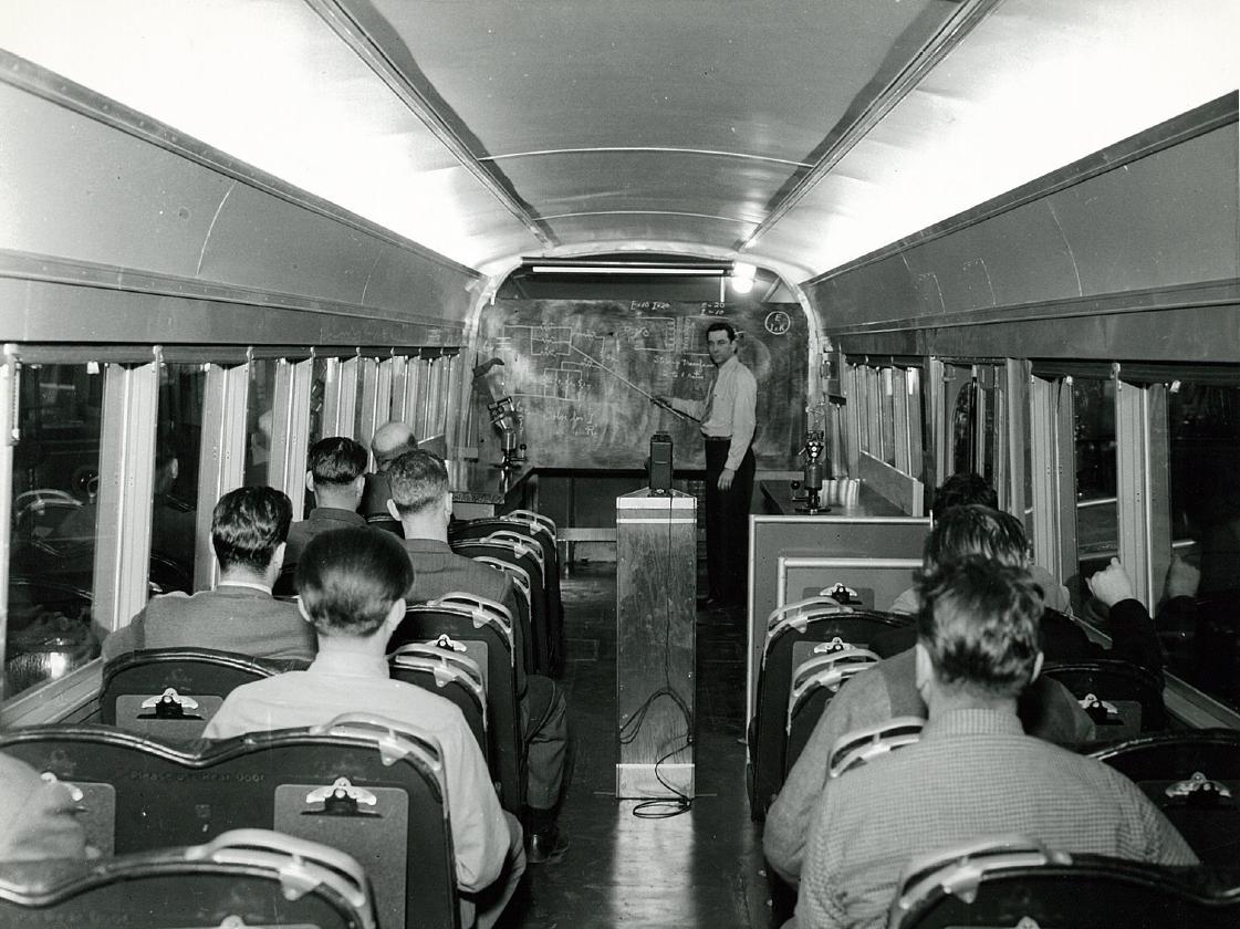