I believe this photo postcard of Chicago Surface Lines 5812 was taken at the 72nd and Cottage Grove loop. Don’s Rail Photos says, “5712 was built by Brill Car Co in 1912, #18322. It was rebuilt as one man/two man service in 1933 and retired on August 25, 1947.” This picture appears to date between 1914 and 1933.
Valentine’s Day is fast approaching, and here we have some tasty traction Valentines for your consideration. First, we have some recent finds of our own, followed by many generously shared from the collections of William Shapotkin. We finish this post with an important find from J. J. Sedelmaier.
-David Sadowski
Recent Finds
LVT 812 in front of the Easton car barn on a June 30, 1947 fantrip. (James Maloney, Jr. Photo)
LVT 710 at Philadelphia, PA on August 19, 1945. (James Maloney, Jr. Photo)
LVT 1000 is on an ERA fantrip, “at the east end of the Ham Street Bridge,” in Allentown on October 29, 1950. (James Maloney, Jr. Photo)
LVT 1003 is at the Allentown car barn in September, 1940. (James Maloney, Jr. Photo)
LVT 1004 in Allentown, October 1939. (James Maloney, Jr. Photo)
LT 1006 at Allentown on January 23, 1943. (James Maloney, Jr. Photo)
LVT 803, in dead storage awaiting scrapping in Allentown, on November 8, 1939. (James Maloney, Jr. Photo)
A single-car CTA Skokie Swift train leaves Howard Street in June 1977.
An artist’s rendering of the high-level us subway the CTA envisioned for Washington Street between Canal and Michigan, 1961.
Indiana Railroad #1150 is southbound at Springport station on the New Castle line on January 1, 1941 in the waning days of that storied Hoosier interurban. (Eugene Van Dusen Photo)
SF Muni cable car 524 is at Powell and Market at 1 am on September 2, 1956.
SF Muni cable car 503 at Washington and Octavia on September 1, 1956.
Cable car track work at Powell and California on October 31, 1957.
Red Arrow Lines Brilliner #7 is running on the street, presumably on the Sharon Hill branch, on November 27, 1960.
On June 3, 1962 Red Arrow car 20 is turning onto a cobblestone street on the Sharon Hill line.
At first, you might think this lineup of NSL cars in dead storage at Highwood (headed up by 158) is post-abandonment, but apparently not. The slide not only has a 1/20/63 date stamped on it (last full day of operations), the slide was processed by Kodak in January 1963.
In this April 11, 1964 view, one of the former North Shore Line Electroliners has been rechristened as a Red Arrow Liberty Liner on the Norristown High Speed Line in Philadelphia’s suburbs. I would expect that the abandoned right-of-way at left is where the Strafford branch once was.
North Shore Line electric loco 456 heads up a short freight train on January 20, 1963– the last full day of operations prior to abandonment.
CTA 7108, already signed for its northbound trip on Route 36, is near 120th and Halsted in the 1950s.
CTA 4095 is eastbound at Lake and Ashland on June 24, 1961. In the background, you can see the old Lake Transfer station, where riders could change (up until February 1951) for Logan Square and Humboldt Park trains.
A CTA two-car Lake Street “L” train heads east in this 1960 photo by Al Holtz.
April 1963.
From the Collections of William Shapotkin
CTA trolley us 9377 is at Irving Park and Neenah. This bus turnaround is no longer in use by CTA, and has now become part of a driveway for a development.
At right, 2411-2412 are on the same fantrip mentioned in the revious photo. At left, a southbound Howard-Dan Ryan train passes the Diversey station on the Ravenswood “L”. William Shapotkin took this picture on December 13, 1998.
At right, CTA cars 2411-2412 are on an NRHS (National Railway Historical Society) fantrip. At left, a southbound Howard-Dan Ryan train blasts by the Armitage station on the Ravenswood “L”. William Shapotkin took this photo on December 13, 1998.
CTA 2177 heads up an Evanston Express train at Armitage on July 10, 1989.
CTA bus 8413 is southbound on Broadway at Lawrence in October 1973, running on Route 36. (Ronald J. Sullivan Photo)
CTA 3140, working a southbound trip on CTA Route 38 – Indiana, heads southbound on Wabash Avenue, crossing Roosevelt Road. Visible above the red car at right is the one-time Union Bus Deport. The view looks north.
CTA trolley bus 9537, working Route 12 – Roosevelt Road, departs its east end terminal at Roosevelt Road east of Wabash Avenue. the view looks north.
CSL 5925 heads southbound on Wabash Avenue and crosses Roosevelt Road. The Union Bus Depot is on the northeast corner. The view looks northeast.
CTA trolley bus 9453, working a westbound trip on Route 12 – Roosevelt Road, has just crossed Wabash Avenue. (The building on the northeast corner is the one-time Union Bus Depot.) The view looks northeast on May 27, 1967, taken from the CTA Roosevelt Road station.) Jeffrey L. Wien Photo, Wien-Criss Archive)
A northbound Lake-Englewood “A” train of 2000-series cars approaches the “L” station at 40th and Indiana in September 1993. (Myron Lane Photo)
A northbound CTA train approaches the Indiana “L” station on the south side of Chicago on June 28, 1992. The occasion was a Central Electric Railfans’ Association fantrip, celebrating a century of rapid transit. (Jim Arvites Photo)
CTA 2821, a wooden Met car running northbound on the Kenwood shuttle circa 1956-57. These were the last type of cars used for that service, which ended in 1957.
We are looking east off the CTA’s Indiana Avenue “L” station in the early 1950s. At left, a Kenwood train has just departed en route to 42nd Place. At right, two 200-series cars (used as equipment on the Kenwood line) are in storage on what once had been the northbound local track of the South Side “L”.
CTA gate car 268 at the Indiana Avenue station “pocket.”
CTA 268 is a Kenwood local, at the Indiana Avenue station.
A two-car train, including #227, is being stored for Kenwood service, on what had once been the northbound local track on the South Side “L”, in the early 1950s.
CTA 385 is at the Indiana Avenue station in July 1948,signed as a Wilson Avenue local via the elevated (instead of the State Street subway, which opened in 1943). The following year, the CTA introduced A/B “skip stop” service to North-South and the Kenwood and Stockyards branches became shuttles.
CTA car #273, working the Kenwood “L” shuttle, is seen at the 40th and Indiana Avenue station. The view looks northeast.
Once the Kenwood and Stockyards ranch lines became full-time shuttle operations, the CTA station at 40th and Indiana Avenue was reconfigured. Here is a Kenwood car in the “pocket.”
Looking west from the west end of the Indiana Avenue “L” station, 4000-series “L” cars are laying over on the Stockyards “L”. 4000s were used on this branch during the 1952 and 1956 political conventions held at the International Amphitheater. (Joseph N. Canfield Photo)
The Indiana Avenue station on the South Side “L” circa 1956. A northbound Englewood-Howard train departs the station, while a Stockyards shuttle train awaits departure time. The view looks east. (Joseph N. Canfield Photo)
Looking east (timetable south) into 63rd and Cottage Grove station on the Jackson Park “L” on May 12, 1996. (William Shapotkin Photo)
A Lake-Jackson Park train approaching 63rd and Cottage Grove on May 12, 1996. The train has crossed over to the northbound track and is arriving at the station. (William Shapotkin Photo)
A southbound Jackson Park train approaches 63rd and Cottage Grove on May 12, 1996. The train is about to cross over and arrive at the station. The view looks west (timetable north) from the north platform. (William Shapotkin Photo)
Chicago, IL. Looking westbound on O’Neil Street (now 23rd Place) from Halsted Street. Well into the 1900s, this was an important terminal/transfer point. Note cable slots– the West Chicago Street Railroad Company’s Halsted-Van Buren cable line terminated in the carbarn at left. This was also the south terminal of Chicago Union Traction’s Halsted line. CUT car #4171 (Pullman 1898) prepares for its northward journey. (Fred J. Borchert Photo)
Chicago, IL. Looking westbound on 23rd (O’Neil) Street from Halsted Street, once a busy street– once a busy streetcar/cable car terminal (with a carbarn). The rails (along with a crossover) are still intact and visible in this July 30, 2004 photo by William Shapotkin.
(William Shapotkin Photo)
Bus stop sign at the northwest corner of 23rd (O’Neil) Street and Halsted Street. The view looks northeast on July 30, 2004. (William Shapotkin Photo)
Chicago, IL. Looking eastbound on 3rd (O’Neil) Street towards Halsted Street, once a busy streetcar/cable car terminal. Both sets of rails (which head onto northbound Halsted) are still visible (as of July 30, 2004) lo these many years since the discontinuance of streetcar service. (William Shapotkin Photo)
Indiana Avenue station on the South Side “L”. Left– a northbound Kenwood train arrives, while at right, a westbound Howard train also arrives. The view looks east off the overhead transfer ridge in 1950. (Joseph N. Canfield Photo)
Another North Shore Line Poster
Following up on our previous post Anniversaries (January 24, 2019), here is an interesting find, courtesy of our friend J. J. Sedelmaier.
Looking north on Chicago’s Michigan Avenue at Ohio Street circa mid-late 1920s. BTW – the billboard on the right was originally produced in 1925 as a South Shore Line one-sheet poster. (J. J. Sedelmaier Collection)
The Trolley Dodger On the Air
We appeared on WGN radio in Chicago last November, discussing our book Building Chicago’s Subways on the Dave Plier Show. You can hear our 19-minute conversation here.
Order Our New Book Building Chicago’s Subways
There were three subway anniversaries in 2018 in Chicago: 60 years since the West Side Subway opened (June 22, 1958) 75 years since the State Street Subway opened (October 17, 1943) 80 years since subway construction started (December 17, 1938)
To commemorate these anniversaries, we have written a new book, Building Chicago’s Subways.
While the elevated Chicago Loop is justly famous as a symbol of the city, the fascinating history of its subways is less well known. The City of Chicago broke ground on what would become the “Initial System of Subways” during the Great Depression and finished 20 years later. This gigantic construction project, a part of the New Deal, would overcome many obstacles while tunneling through Chicago’s soft blue clay, under congested downtown streets, and even beneath the mighty Chicago River. Chicago’s first rapid transit subway opened in 1943 after decades of wrangling over routes, financing, and logistics. It grew to encompass the State Street, Dearborn-Milwaukee, and West Side Subways, with the latter modernizing the old Garfield Park “L” into the median of Chicago’s first expressway. Take a trip underground and see how Chicago’s “I Will” spirit overcame challenges and persevered to help with the successful building of the subways that move millions. Building Chicago’s subways was national news and a matter of considerable civic pride–making it a “Second City” no more!
Bibliographic information:
Title Building Chicago’s Subways Images of America
Author David Sadowski
Edition illustrated
Publisher Arcadia Publishing (SC), 2018
ISBN 1467129380, 9781467129381
Length 128 pages
Chapter Titles: 01. The River Tunnels 02. The Freight Tunnels 03. Make No Little Plans 04. The State Street Subway 05. The Dearborn-Milwaukee Subway 06. Displaced 07. Death of an Interurban 08. The Last Street Railway 09. Subways and Superhighways 10. Subways Since 1960
Building Chicago’s Subways is in stock and now available for immediate shipment. Order your copy today! All copies purchased through The Trolley Dodger will be signed by the author.
The price of $23.99 includes shipping within the United States.
For Shipping to US Addresses:
For Shipping to Canada:
For Shipping Elsewhere:
Redone tile at the Monroe and Dearborn CTA Blue Line subway station, showing how an original sign was incorporated into a newer design, May 25, 2018. (David Sadowski Photo)
Help Support The Trolley Dodger
This is our 227th post, and we are gradually creating a body of work and an online resource for the benefit of all railfans, everywhere. To date, we have received over 488,000 page views, for which we are very grateful.
You can help us continue our original transit research by checking out the fine products in our Online Store.
As we have said before, “If you buy here, we will be here.”
We thank you for your support.
DONATIONS
In order to continue giving you the kinds of historic railroad images that you have come to expect from The Trolley Dodger, we need your help and support. It costs money to maintain this website, and to do the sort of historic research that is our specialty.
Your financial contributions help make this web site better, and are greatly appreciated.
Chicago postwar PCC 7216 is shown heading south on Clark at Harrison on March 11, 1958. I was attracted to this shot since the woman and child who are about to board could just as well be me and my mother at that time. (Photo by A. Goddard)
June 21st marks 60 years since the last Chicago streetcar ran. If you consider that 80 years is, perhaps, about an average lifespan, that means 3/4ths of such a time has now passed since that historic event.
The number of people still living who rode Chicago streetcars is dwindling, and is certainly only a small fraction of the current population. At age 63, I must be among the youngest people who can say they rode a Chicago streetcar on the streets of Chicago, much less remember it.
But the number of people who have taken a ride on a Chicago streetcar does increase, since there are a number of them that are operable at the Illinois Railway Museum in Union. The Seashore Trolley Museum (Kennebunkport, ME) has another car (225) that is operated infrequently.
The experience of riding at a railway museum is, of necessity, somewhat different than what people experienced 60+ years ago on the streets of Chicago. However, as a “streetcar renaissance” is underway across the country in various cities, the number of track miles in city streets has been increasing. In those places, it is possible to experience something more like what Chicago once had.
Milwaukee, Wisconsin will soon join that list, just 90 miles north of Chicago. After a similar 60-year gap in streetcar service, their first new line, aka “The Hop,” is expected to begin service mid-November. (You can read our recent update here. Since our article appeared, the new cars have begun testing out on the streets.)
Interestingly, a heritage trolley recently began service in Rockford, Illinois, which is also about 90 miles from Chicago.
For the past 18 years, Kenosha, Wisconsin (about 65 miles from Chicago) has operated a tourist trolley, which you can even reach using Metra‘s Union Pacific North Line.
Perhaps the streetcar line that would offer a ride closest to what Chicagoans could once experience, however, is the SEPTA #15 Girard Avenue line in Philadelphia, which is operated with modernized PCC cars.
I can also recommend the Muni F-Market and Wharves line in San Francisco, which operates using a variety of historic equipment.
Anyway you look at it, this anniversary is a good excuse to feature some classic Chicago traction photos, which we hope you will enjoy.
But wait– there’s more!
June 22, 1958 is another important date in Chicago transit history. 60 years ago, a new CTA rapid transit line opened in the median of the Congress (now Eisenhower) expressway. This line, also known as the “West Side Subway,” replaced the Garfield Park “L” and was the culmination of plans made 20 years before.
Another important anniversary is approaching on October 17th– the 75th anniversary of the opening of Chicago’s first subway. In December, it will be 80 years since subway construction began.
For these reasons, and more, we have written a new book called Building Chicago’s Subways, to be released by Arcadia Publishing this October 1st. Information about how to pre-order this book appears further down in this post.
The idea for Building Chicago’s Subways first came to me a few years ago, when I realized these important anniversaries were approaching. A few months after the publication of Chicago Trolleys last fall, I pitched the idea to Arcadia, and that is when the real work began.
Much additional research had to be done. I read everything I could find on the subject. Photos came from my own collections and those of other collectors, who have graciously permitted their use in this project.
Here is a short description of the book:
While the elevated Chicago Loop is justly famous as a symbol of the city, the fascinating history of its subways is less well known. The City of Chicago broke ground on what would become the “Initial System of Subways” during the Great Depression and finished 20 years later. This gigantic construction project, a part of the New Deal, would overcome many obstacles while tunneling through Chicago’s soft blue clay, under congested downtown streets, and even beneath the mighty Chicago River. Chicago’s first rapid transit subway opened in 1943 after decades of wrangling over routes, financing, and logistics. It grew to encompass the State Street, Dearborn-Milwaukee, and West Side Subways, with the latter modernizing the old Garfield Park “L” into the median of Chicago’s first expressway. Take a trip underground and see how Chicago’s “I Will” spirit overcame challenges and persevered to help with the successful building of the subways that move millions. Building Chicago’s subways was national news and a matter of considerable civic pride–making it a “Second City” no more!
The story goes back much further than that… before there were rapid transit tunnels, there were tunnels under the Chicago River, used by cable cars and streetcars. In the early 1900s, private enterprise built an extensive system of freight tunnels under the downtown area. And there was about 40 years of wrangling over what kind of subway to build, where to build it, and who should pay for it.
I found it a fascinating tale, and am gratified that I have been able to complete this new book in time for the anniversary, and within the living memory of Chicagoans who were here to witness these events 75 long years ago. The State Street, Dearborn-Milwaukee and West Side Subways have changed life for everyday Chicagoans forever.
-David Sadowski
PS- The Chicago Transit Authority posted this excellent video showing the last run of car 7213 in the early morning hours of June 21, 1958 (the June 22 date in the video is not correct):
Jeffrey L. Wien and I, along with the late Bradley Criss, collaborated on the book Chicago Streetcar Pictorial: The PCC Car Era, 1936-1958, published in 2015 as Bulletin 146 of the Central Electric Railfans’ Association.
For this anniversary, I asked Mr. Wien, who rode on the last Chicago streetcar, to reminisce for our readers:
Today, June 21, 2018, marks the 60th anniversary of my ride on the Last Chicago Streetcar with my high school friend Greer Nielsen. Thinking back 60 years I recall that it was a very melancholy event, one that remained in my mind for the rest of my life.
Thinking back 60 years can be a challenging task, but I do remember that it was a warm and muggy night on that last ride. CTA PCC 7213 was the last car on the shortened route 22 Wentworth line. The last run south from Clark and Kinzie began around 4am. There were probably at least 100 people crammed into that car so that they could say that they rode the Last Chicago Streetcar. As the car headed south through the Loop headed to 81st and Halsted, the group was quite loud and raucous, but as we went farther and farther south, the crowd quieted down, perhaps because we wanted to hear the sound of the streetcar in the streets of Chicago for the very last time.
When we arrived at 81st and Halsted, everyone got off the car for photos, private and official, and then reboarded the car for the last time for the short trip to Vincennes and 78th where the car pulled off of the street. It was about 6:15am by that point in time, and the Sun was just rising.
As the 7213 pulled away from Vincennes Avenue heading into the Rising Sun, we knew that we had witnessed an historic event in the history of Chicago. 99 years of traction history in Chicago ended at that moment. For me, it was a very sad moment for it was like losing a very good friend.
Jeff Wien
Chicago Area Recent Finds
Chicago’s PCCs did not operate in multiple units, but you would be forgiven for thinking so from this photo. Car 4172 and a very close follower are heading south at Clark and Division circa 1950. Note there are not yet any advertising brackets on the sides of the PCCs. At right, there is an entrance to a CTA subway station, which is today part of the Red Line.
CTA PCC 4366, a Pullman, heads north on diversion trackage on Halsted at Congress in 1950. This was necessitated by construction of the bridge that would go over the Congress expressway (now the Eisenhower, I290). Bridges that crossed the highway were the first things built, since traffic could be routed around them. Once a bridge was finished, the area around it could be dug out.
CTA PCC 7148, running northbound on Route 36 – Broadway, turns from Broadway onto westbound Devon in 1955, with the Howard line “L” in the background. The date written on this slide mount is 8-14-56, but the turning car has a 1955 Illinois license plate on it, so perhaps the correct date is 8-14-55. (William Shapotkin Collection)
CTA Pullman-built PCC 4124 is eastbound on Route 20 – Madison at Cicero Avenue in 1953. The PCC is signed for Kedzie, so it is most likely a tripper, heading back to the barn. Streetcar service on the main portion of Madison ended on December 13, 1953.
The same building as in the previous picture.
Rust never sleeps, as the saying goes, and that is evident in this picture of a Chicago Surface Lines (now CTA, but still sporting a CSL logo) electric loco as it looked in the 1950s. Behind it is one of the CSL trailers that were used during the 1920s, pulled along behind other streetcars. Once ridership dropped during the Great Depression, these were used for storage at various CSL yards.
In August 1960, a four-car train of CTA 4000-series cars heads west on the ground-level portion of the Lake Street “L”. Since it appears there are passengers waiting for a Chicago & North Western commuter train on the adjacent embankment, I would say it’s possible the location is near Marion Street in suburban Oak Park. The outer 2.5 miles of the Lake route were relocated onto the embankment in October 1962.
CTA 4295 heads up a train in Oak Park on the ground-level portion of the Lake Street “L” on August 7, 1954. (Photo by Mark D. Meyer)
Two CTA 4000s go up the ramp on Lake Street, just west of Laramie, to rejoin the steel “L” structure east of here on November 30, 1952. (Robert Selle Photo)
In September 1959, we see a two-car train of CTA 4000s, preparing to head east. I believe the location is Marion Street in Oak Park and not Marengo Avenue in Forest Park as written on the slide mount. Marengo is a short distance west of Harlem, and although Lake Street trains did go there, the buildings in this picture match Marion. We have another picture in this post showing what the area west of Harlem actually looked like. (William Shapotkin Collection)
Photographer Bob Selle notes: Two-car “L” train (4420 at right) on Lake Street line just west of Harlem Avenue.” In the distance, you can see the actual terminal. Not that many people boarded there, compared to the Marion Street station just east of Harlem Avenue. This picture was taken on May 1, 1955.
A close-up of the previous picture, showing some wavy track and the actual station and bumper post (or is it turned-up rail?) at the west end of the Lake Street “L” prior to 1962. Riders could board trains at the station, which was located about two blocks west of Harlem Avenue.
CTA one-man car 3125, heading west on Route 16, is turning north from Lake Street onto Pine Street, where Lake takes a jog. In the process, it crosses the ground-level Lake Street “L”. This picture was taken on September 26, 1953. (Robert Selle Photo)
A two-car train of 4000s is on the Lake Street “L” during construction of the Northwest (now Kennedy) expressway on February 25, 1958. The new highway opened in 1960. Further south, the Garfield Park “L” also crossed the highway footprint and had to be shored up around the same time this photo was taken. But once the new Congress rapid transit line opened on June 22, 1958 the Garfield line was no longer needed and the structure was removed where it crossed the highway, cutting the line off from the rest of the system. The remaining portions of structure west of there were removed in 1959; east of there, parts remained until 1964. The Lake Street “L”, on the other hand, rechristened the Green Line, is still here.
In this picture, taken in April 1964, we see the back end of a CTA two-car train of 4000s as they head east at Halsted on the Lake Street “L”. By this time, the western portion of the line had been relocated onto the C&NW embankment, and therefore there was no further need to use overhead wire. But the new 2000-series “L” cars had not yet replaced the 4000s in this line, which they would do shortly. This station, built in 1892-93, was closed in 1994 for the Green Line rehabilitation project, but never reopened. It was demolished in 1996 and the new Morgan station, two blocks to the west, more or less replaced it when it opened in 2012.
On August 13, 1964 CTA single-car unit 45 prepares to stop at Isabella station on the Evanston line. The car is signed as an Evanston Express, but I do not think it would have operated downtown as a single car. Therefore, it must be in Evanston shuttle service. (August 13, 1964 was a Thursday, so the Evanston Express was running that day, though.) (Photo by Douglas N. Grotjahn)
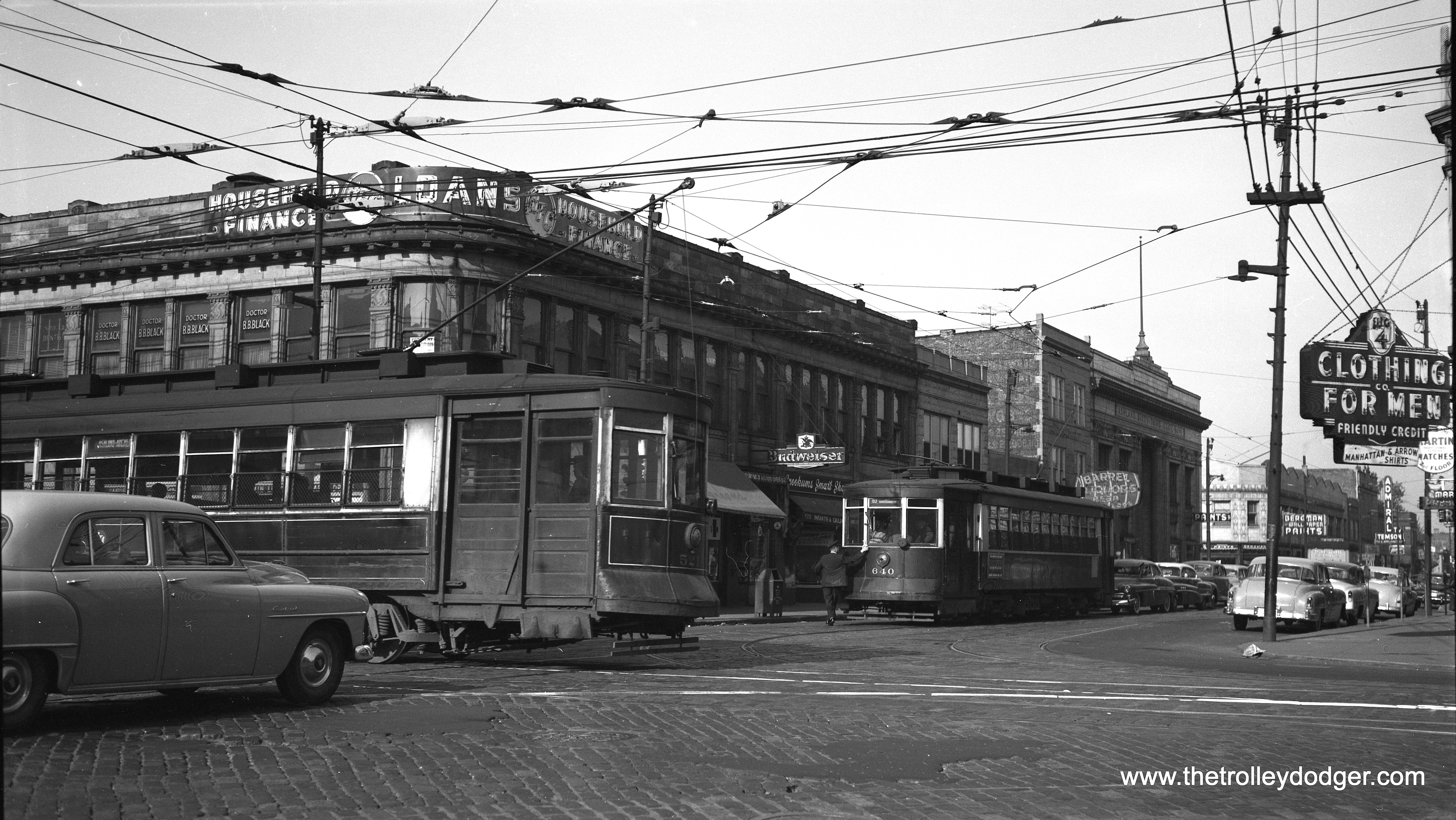
CTA red Pullmans 521 (on Ashland) and 640 (on 63rd Street) meet on May 14, 1953. This was near the end of streetcar service on 63rd. By then, PCC cars had been transferred from 63rd to Cottage Grove. The Curtis restaurant, located in this vicinity but behind the photographer, was a favorite of my parents. It is perhaps no coincidence that I have a brother named Curtis. (Robert Selle Photo)
CTA PCC 4095, built by Pullman, has just left the Madison-Austin loop on the west end of Route 20 on June 1, 1953. Buses continue to use this loop today, although it has been somewhat reconfigured. (Robert Selle Photo)
CTA 4271-4272 head up a northbound Evanston Express train passing through the Chicago Avenue station on June 26, 1958. These two cars, which were originally independent but were converted to semi-permanent “married pairs” in the 1950s, are still on CTA property and within a few years will celebrate their centennial. When the last of the 4000-series “L” cars were retired in 1973, these were chosen for preservation as historic cars. They are occasionally used for special events. (Robert Selle Photo)
CTA red Pullman 270 is on Cicero at North Avenue, where Cicero took a bit of a jog which has since been somewhat straightened out. The date is July 19, 1948. (William Shapotkin Collection)
CTA trolleybus 9219 on Route 77 – Belmont, running eastbound at approximately 952 W. Belmont (near Sheffield). The photographer was up on the north-south “L” platform. (William Shapotkin Collection)
The building in the previous picture is still there. For several years, there was a club on the second floor, first called the Quiet Knight, later on Tut’s. I attended many great concerts there in the 1970s and 80s.
Chicago Surface Lines 1775 crosses the Chicago River at Wabash Avenue on May 30, 1945, promoting the WAVES (Women Accepted for Volunteer Emergency Service). The nearby State Street bridge was out of service from 1939 to 1949 due to subway construction and wartime materials shortages.
CSL 1775, decorated to promote the SPARS*, is on 119th one block west of Halsted in August 1943. Car 1775 was chosen for patriotic duty because that was the year the Revolutionary War broke out, with the Battles of Lexington and Concord. *The United States Coast Guard (USCG) Women’s Reserve, better known as the SPARS, was the World War II women’s branch of the USCG Reserve. It was established by the United States Congress and signed into law by President Franklin D. Roosevelt on 23 November 1942.
On August 25, 1946 CSL one-man car 3093 is running outbound on private right-of-way between Morgan and Throop on Route 23, Morgan-Racine-Sangamon.
On May 25, 1958 we see CTA two-man PCCs 7206 and 4390 at 78th and Wentworth (South Shops). Both were products of St. Louis Car Company, as all 310 postwar Pullman PCCs had been scrapped by then for the “PCC conversion program” that used some of their parts in new 6000-series rapid transit cars. In spite of the roll signs shown here, Chicago streetcars were limited to running on a single route between downtown and the south side. The last northside car ran in 1957. (Robert Selle Photo)
CTA PCC 7151, a product of St. Louis Car Company, heads south on Route 49 – Western at North Avenue in 1953. The “L” station behind it was part of the Humboldt Park branch, which was abandoned in 1952. Once the station was closed, signs advertising “L” service were removed although I don’t believe this portion of the structure was removed until the early 1960s. Note that riders at this safety island are boarding at the rear, as this is a two-man car.
CTA 4393 is at the 79th and Western loop, south end of Route 49, on July 19, 1954. (Robert Selle Photo)
CTA PCC 4376 is turning into the loop at 79th and Western, south end of Route 49, on July 19, 1954. (Robert Selle Photo)
On May 1, 1955 CERA held a fantrip using 2800-series wooden “L” cars. Here, the train makes a photo stop at DesPlaines Avenue in Forest Park, then the western end of the Garfield Park “L”. The terminal had been reconfigured in 1953 when CA&E trains stopped running downtown. It would be reconfigured again in 1959. By 1960, the Congress expressway was extended through this area. (Robert Selle Photo)
CTA two-man arch roof car 3189 is southbound on Halsted Street near the Garfield Park “L” overpass, south of Van Buren Street on September 17, 1953. As had previously happened with 63rd Street, PCCs had been taken off this route and replaced by older red cars for the final few months of service. 3189 is on the bridge that would eventually go over the Congress expressway, which was then under construction. (Robert Selle Photo)
Here’s what photographer Bob Selle wrote on this negative envelope: “”L” cars fresh from the paint shops, MU-coupled, for trip to South side “L” lines: deck roofer 2912 and steel car 4224 at Quincy and Wells platform. June 14th, 1955.”
CSL 4062 was the first postwar PCC put into service. It was built by Pullman. Here, we see it as delivered at 78th and Vincennes on September 30, 1946. Note the different paint scheme the first cars had in the “standee” windows area.
CSL 298 is on Wabash at Cermak on September 14, 1934.
This picture of CTA one-man car 3236, taken on January 14, 1950 shows it crossing Maplewood Avenue on what is obviously an east-west trolley line. John F. Bromley, who sold me this negative, was unsure of the location. Jeff Wien writes, “I would guess that it is at 71st & Maplewood. Bill Hoffman lived all of his life at 6664 S. Maplewood which was a half mile north. Maplewood is a block or two west of Western. Route 67 covered 67th, 69th and 71st as far west as California (2800). Maplewood is around 2600 West. Check out the streets to see if I am correct. The one man cars were used on route 67.” Looks like Jeff is correct, as further research shows that the house at left is still standing at 7053 S. Maplewood.
Photographer Bob Selle writes, “CTA one-man car 6174 eastbound as it crosses Halsted Street on Root Street (43rd Street line), leaving west end of line. August 1, 1953.”
Photographer Bob Selle writes, “Car 6177 leaving south end of Kedzie barn for Cermak Road, February 14, 1953.”
CTA Pullman-built PCC 4084 leaving the Kedzie Station (car barn) on September 13, 1950. The car at right appears to be either a 1949 or 1950 Ford. My father had a 1949 model, and as cars were very much in demand after the end of World War II, the dealer put him on a waiting list. After being on the list for six months, he found that he had actually gone further down the list than he was at the start! So he wrote a letter complaining about this to Henry Ford II, and the next thing you know, they sold him a car. Presumably the PCC is heading out on Route 20 – Madison. (Robert Selle Photo)
This negative did not come with any identifying information, but it is obviously from a February 12, 1939 fantrip where the fledgling Central Electric Railfans’ Association chartered Chicago Rapid Transit Company “L” cars 4317 and 4401 and took them out on parts of the CA&E including the Mount Carmel branch. However, since that line used overhead wire, that’s not where this picture was taken. Instead, it appears to be out near the end of the line at Mannheim and 22nd Street on the CRT’s lightly used Westchester line, which was built in anticipation of housing being built in this area (which did not come about until the 1950s). South of Roosevelt Road, the line was single-track, which appears to be the case here. If not for the Great Depression, more housing would have been built here. We have previously run two other pictures from the same fantrip, both taken on the Mt. Carmel branch. The CTA substituted bus service for “L” on the Westchester line in 1951 as it did not want to continue paying rent to the CA&E, which had already announced its intentions to truncate passenger service to Forest Park, which meant similar rent payments to the CTA were about to cease.
CTA PCC 4087 leaves the Kedzie car barn during the morning rush on July 1, 1953 and is signed for the Madison-Fifth branch line. (Robert Selle Photo)
The end is near for CTA 4402 and the other couple dozen or so PCC cars that remained at the end of service. Ultimately, only car 4391, now at the Illinois Railway Museum, was saved. This picture was taken at 77th Street yards on June 15, 1958. (Robert Selle Photo)
CSL 5387 is westbound at 63rd and Dorchester, having just gone under the Illinois Central viaduct on June 13, 1947. Even though this neg was lightstruck on the top edge (almost all of which I cropped out), I thought it was an interesting streetscape with the diner and what appears to be some sort of pawn shop or resale shop. The Jackson Park branch of the “L” went over the IC at this point, and has since been cut back.
On August 28, 1955 Illinois Central Electric suburban 1161 and its trailer are crossing Halsted Street at 121st on their way to Blue Island. There was a fantrip that day (hence the fans,), but this was not the fantrip train apparently. (Robert Selle Photo)
CSL 1872 is on Franklin at Jackson on June 13, 1947.
CSL red Pullman 293 is at Roosevelt and Wabash on June 13, 1947.
This Chicago, Aurora & Elgin image is from an original 1950s Kodachrome slide that was not processed by Kodak. I am not quite able to make out the car number, but it looks like it is one of the 420s. The location is downtown Elgin, along the Fox River. The Rialto Theater burned down in 1956.
This picture is somewhat blurred, which makes one wonder why the late Edward Frank, Jr. printed it and sold it. But it does show CSL 1819 and a passing Chicago, Aurora & Elgin train. The curved section of track suggests this may have been taken near the Sacramento curve. That’s probably Ed Frank’s bicycle in the lower right hand corner.
It is not often that individual employees can be identified in an old photo such as this, which shows CA&E express freight car #5 (presumably, the second #5, built by Cincinnati Car Company). But the man at left is Clyde Goodrich, a longtime engineer on the interurban. As far as I know, he was still employed there up to the final 1959 abandonment of service.
Clyde B. Goodrich, the man in the left, was born in DeKalb, Illinois on May 17, 1887 and died in Florida on September 1, 1970. His wife’s name was Winifred (1882-1955). In 1920, Clyde lived in Aurora and was employed by the Chicago, Burlington & Quincy. In the 1940 census, he was living in Wheaton and worked as an engineer on the Chicago, Aurora & Elgin. Clyde B. Goodrich and his wife are buried in Wheaton Cemetery.
The caption here reads, “North Western and electric lines stations, Wheaton.” The CA&E is in the foreground. The photo is not dated, but it must be quite early.
This photo, dated May 1966, shows the CA&E’s Wheaton station being torn down.
Demolition is nearly complete in this photo, also dated May 1966.
CA&E wooden interurban car 54. Don’s Rail Photos: “54 was built by Stephonsin in 1903. It was modernized in July 1946 and retired in 1959.”
CA&E wooden freight motor 9. Don’s Rail Photos: “9 was built by Niles Car in 1907. It was scrapped in 1959.”
A crane on a CA&E flat car. This appears to be Wheaton Yard.
North Shore Line car 182 is southbound on the Shore Line Route in North Chicago, Illinois on June 12, 1954. Don’s Rail Photos: “182 was built by Cincinnati Car in September 1920, #2455.” (Robert Selle Photo)
While Chicago’s Congress expressway (now the Eisenhower) is rightly considered its first, Lake Shore Drive preceded it as an “almost” expressway. Here. we see construction taking place on December 13, 1940. Until 1979 LSD had lanes that could be reversed in rush hour by raising and lowering these short barriers. Unfortunately, this resulted in a number of head-on collisions, and these were eventually deactivated. The photo caption reads, “Workmen install line of elevating curbs in new express highway on Chicago’s lake front. The curbs, placed two lanes apart on the eight lane roadway, give extra lanes to rush hour traffic to ease traffic flow. The elevating jacks shown raise the curb to height of nine inches, exert pressure of 12 tons. The retracting springs, having a 10-ton pressure, pull the curbs down when the hydraulic jacks are released. The entire curb system is operated from one central control station.” (Photo by Acme)
Chicago’s Loop in 1959
The following ten images are part of a larger batch we recently purchased. Several of the others show various downtown movie theaters (including the Clark and Garrick) and will be posted in the near future on our “sister” Clark Theater blog. By studying the various films that were playing, I have determined these pictures were taken during the summer of 1959.
Here’s a rather unique view showing the front of the old Wells Street Terminal, or what was left of it anyway, as it appeared in 1959. This terminal was last used by the CA&E in 1953. Two years later, the upper portion of the attractive facade was removed and a new track connection was built so that Garfield Park trains could connect to the Loop “L”. A new connection was needed, since the old one had to give way to construction on Wacker Drive. The remainder of the terminal, and the track connection, were no longer needed after the Congress rapid transit line replaced the Garfield Park “L” in 1958, and they were removed in 1964. Note there is a barber shop occupying part of the building.
A two-car train of CTA 4000s, running on the Lake Street “L”, are at Wabash and Van Buren on the Loop. In the background, you can see the Auditorium Theater building.
The old Epicurean restaurant, at left, was located at 316 S. Wabash and served Hugarian cuisine. A CTA Lake Street train rumbles by above.
A street sign is just barely visible in this photo taken under the Loop “L”, identifying the cross street as Dearborn. Since that is one way southbound downtown, and the arrow is pointing to the right, that implies we are in Lake Street and are looking to the east.
The old Metropolitan “L” crossed the Chicago River just south of Union Station (just visible at left) and had four tracks, necessitating two bridges. After these tracks were taken out of service in June 1958, the bridges were permanently raised, and razed in 1964.
Another view of the same two Met “L” bridges in 1959.
Another photo of the two Met “L” bridges.
It’s not clear where this picture was taken. The two wires that cross the trolley bus wires are, I am told, “feeder span hangers.” The last Chicago trolley bus ran in 1973. The CTA currently has two electric buses that run on batteries, and has just placed an order for 20 more.
Another view of the Loop “L” on south Wabash, probably taken near the locations if the other similar photos showing Lake Street trains.
This photo shows what State Street, that great street, looked like during the summer of 1959. We are looking north from about 400 S. State. The Goldblatt’s department store is at right, and that’s a CTA #36 bus heading south. Streetcar tracks on State have either been removed, or paved over. Note the “grasshopper” style street lights that were installed in 1959.
FYI, here is another view from the same location, taken after streetcar tracks were removed, but before the 1959 installation of those unique street lights:
(See attribution information for this photo via the link provided above.)
Miscellaneous New Finds
This photo purports to show the actual last run on Milwaukee’s ill-fated Speedrail interurban on June 30, 1951. However, according to Larry Sakar, author of Speedrail: Milwaukee’s Last Rapid Transit?, “The last run to Waukesha which left Milwaukee at a little after 8:00 pm and returned to Milwaukee at 10:08 pm, 2 minutes ahead of schedule, was handled by duplex 37-38. The final round trip to Hales Corners was handled by curved side car 63, not 66. 66 did run on the last day, but it was by no means the final run.” Chances are this photo was at least taken on the last day. The line could not survive the repercussions of a terrible head-on collision in 1950, and Milwaukee area officials wanted to use the interurban’s right-of-way, which it did not own, for a new highway. Don’s Rail Photos: “66 was built by Cincinnati Car in August 1929, #3025, as Dayton & Troy Ry 203. It was returned to Cincinnati Car in 1932, and in 1938 it was sold to Lehigh Valley Transit as 1102. In 1949 it was sold to Speedrail, but was not rehabilitated until March 1951. But it only ran for 3 months before the line was abandoned and then scrapped in 1952.” (Photo by George Harris)
Early Kodachrome images such as this are rare. Here, we see a San Francisco cable car (signed for Powell and Mason) in operation during the summer of 1945. When this picture was taken, the war in Europe had ended, but the US was still fighting Japan. According to the Cable Car Museum web site, this car is currently in service as #3: “Built by the Carter Bros. of Newark, California during 1893-1894 for the Market Street Railway’s Sacramento-Clay cable car line. The United Railroads transferred it to the Powell Street cable car lines in 1907, after the Earthquake and Fire of 1906. Until 1973, numbered as No. 503. No. 3 is painted in Muni’s green and cream paint scheme, which is based on the green and white scheme of the Muni’s former rival between 1921-1944, the Market Street Railway. This was the basic paint scheme for Powell Street cable cars from 1947 to 1982. Extensive rebuilding, by Muni 1955.”
PTC “Peter Witt” 8057 was built by Brill in 1923. Here it is seen on Route 34 in the 1950s. Michael T. Greene writes: “The picture of the Route 34 Peter Witt was taken at 38th and Locust Streets, on what’s now the campus of the University of Pennsylvania. (An alum now resides at 1600 Pennsylvania Avenue, NW, in Washington, but enough of that!). The trolley is using detour trackage onto Locust Street EB, as part of the subway-surface extension of the 1950’s…westbound trackage continued on Locust to 40th Street, where it hung a left turn. Today, 38th Street has been widened to a 2-way street, but still with a trolley track, used as a diversion route for subway-surface Routes 11, 13, 34, and 36. Locust Street was been turned into a pedestrian walkway, and a pedestrian bridge goes over 38th Street these days.”
Philadelphia Transportation Company 7266 is on Route 9, sometime in the 1950s during street construction. Micheal T. Greene writes: “The Route 9 car is on 5th Street south of Market Street. At this time, 5th Street was being widened as part of Independence Mall. Independence Hall is out of this picture to the right.”
Indianapolis Railways “Peter Witt” car 181, also known as a “Master Unit,” a Brill trademark, is signed for College-Broad Ripple on April 16, 1952. This car was built in March 1934 and was one of the last streetcar orders filled before the PCC era. (Robert Selle Photo)
Indianapolis Railways 155 was built by Brill in September 1933. On May 21, 1950 it is at the east end of the Washington Street line on a fantrip.
On August23, 1946, photographer Walter Hulseweder snapped this picture of Indianapolis Railways 131 on Washington Street at Illinois Avenue on the Washington-Sheridan line.
By strange coincidence, this photo showing a Rock Island Motor Transit Company bus was taken in June 21, 1958. Bill shapotkin adds, “The photo was taken at the joint CGW/Greyhound/Jefferson bus station in Rochester, MN. This bus provided connections from/to ROCK trains at Owatonna, MN.” (William Shapotkin Collection)
Mystery Photo
This picture, which could be as old as the 1930s, was listed by the seller as being Chicago. However, I have my doubts, as I am unable to think of a location this could be around here, or what the construction project might be. The sign says “Detour to temporary bridge.” Jeff Wien thinks this might be Philadelphia.
Updates
We’ve added another image to our previous post The Fairmount Park Trolley (November 7. 2017), which includes an extensive section about the Five Mile Beach Electric Railway in Wildwood, New Jersey:
Five Mile Beach Electric Railway car 36 at Warehouse Point, Connecticut on August 16, 1952.
A SEPTA commuter train, ex-PRR, at West Chester in May 1979. SEPTA rail service to this station ended in 1986, but the West Chester Railroad began running a not-for-profit tourist operation of train service on weekends between West Chester and Glen Mills in 1997. (Photo by Paul Kutta)
Red Arrow “Master Unit” 79 is inbound in 1949 on either the Media or Sharon Hill line, in spite of the sign saying Ardmore (thanks to Kenneth Achtert for that correction). He adds, “It was (still is) standard practice for Red Arrow operators, when changing ends at the outer end of their route, to set the sign on what would be the rear of the car for the inbound trip to read their next outbound destination. Thus, when the car arrived at 69th St. Terminal and went around the loop to the boarding platform the rear destination sign was already set. This was actually the more important sign, as most passengers approached the cars from the rear coming from the main terminal (and from the Market-Frankford Elevated line).” (Mark D. Meyer Photo)
Red Arrow “Master Unit” 82 is at the 69th Street Terminal on August 8, 1948. (Walter Broschart Photo)
On September 12, 1959, Philadelphia Suburban Transportation 3, a 1941 “Brilliner,” is on Lippincott Avenue north of County Line Road, on the short Ardmore line which was bussed in 1966.
Philadelphia Suburban Transportation Company (aka “Red Arrow”) cars 5 and 14 pose at 69th Street Terminal on June 22, 1963. The car at left is a Brilliner, from the last batch of trolleys built by Brill in 1941. The car at right was built by the St. Louis Car Company in 949. Although it looks much like a PCC, it was not considered such as it had standard interurban trucks and motors. Both types of cars were double-ended.
We’ve added this image to our extensive section about the Fort Collins (Colorado) Birney car operation in Our 150th Post (August 6, 2016):
Fort Collins Municipal Railway Birney car 22 in the city park on April 30, 1947.
Recent Correspondence
Our resident South Side expert M. E. writes:
Your latest post has a bunch of good stuff.
https://thetrolleydodger.com/wp-content/uploads/2018/06/proofs116.jpg Interesting that you think this picture might be of your mother and you. In the book “In Search of Steam” by Joe Collias (which I do not have), there is a picture taken at Englewood Union Station of a young boy, bundled in winter clothing, watching a New York Central steam engine come into the station. I’d swear that young boy is me.
The movie of the last PCC streetcar almost made me cry. My last ride on a Chicago streetcar occurred in early June when my high-school best friend and I rode one car from 81st and Halsted to 63rd and Wentworth, then another car ack to 81st and Halsted. Also: Probably less than a week after the last streetcar ran, I graduated high school. So this time frame is especially meaningful to me. (Please don’t publish this, it’s just for your information.)
https://thetrolleydodger.com/wp-content/uploads/2018/06/proofs138.jpg The text under this picture says the South Shops was at 78th and Wentworth. Not so. South Shops was at 77th and Vincennes on the east side of Vincennes. And the land it occupied was huge — from 77th and Vincennes east to about Perry (a block west of State St.) and south to 79th. I haven’t been there in a long time, but maybe the CTA still has all that land.
https://thetrolleydodger.com/wp-content/uploads/2018/06/proofs1611.jpg I’d have to agree that this car is on 71st St. west of Western. Because you say 7053 S. Maplewood is at the left, I contend the streetcar is heading west to 71st and California. One small nit: The caption says “Bill Hoffmann lived all of his life at 6664 S. Maplewood.” Unless there was an extra-long block between 66th and 67th (Marquette Blvd.) on Maplewood, the address would have to be 6654. Normally there are 60 addresses to a block, from 00 to 59.
https://thetrolleydodger.com/wp-content/uploads/2018/06/proofs160.jpg This is an interesting picture. As the caption indicates, the car had just left the west end of its line. That west end was west of Halsted between two buildings. It was a dead end, providing only a switch from westbound to eastbound track. Also: You previously published a photo taken here, on Halsted St. south of Root, looking north. In that photo was a 44 Wallace-Racine car turning from west on Root to south on Halsted. (In this current photo you can see the trackage for this turn.) Also in that previous photo was the Halsted St. station of the Stock Yards L.
https://thetrolleydodger.com/wp-content/uploads/2018/06/proofs160.jpg This is your mystery photo. I agree that this can’t be a Chicago scene, for the reason that I know of no elevated trackage in Chicago that was so low to the ground. Also, the elevated train does not look like any Chicago L train I remember.
M E
Thanks very much for your interesting observations!
I don’t think that the woman and boy actually are me, but they certainly resemble us in 1958. My mother dressed like that all the time, and the kid is about my age.
We lived on the west side, in Mont Clare. My mother’s parents lived in Englewood and that’s where she was living when my parents met. So naturally, they frequented restaurants in the neighborhood.
63rd and Ashland was bustling back then.
The June 18, 1958 Southtown Economist gives Dorothy Hoffman’s address as 6622 S. Maplewood. I believe Bill Hoffman lived with his sister, so perhaps that is the correct address.
If you think 63rd and Ashland was busy, you should have seen 63rd and Halsted, which was the heart of Englewood. Somewhere I once read that 63rd and Halsted was the busiest commercial district in Chicago outside the Loop. It was a great place to grow up because there were three streetcar lines (8, 42, 63), the Englewood L (which I could see from our building), and railroad stations east on 63rd at Wallace and La Salle.
Good point! People tend to forget these things, as certain areas of the city became depopulated to some extent, and urban renewal leveled entire blocks.
We’ll let Jeff Wien have the last word:
Streetcars, streetcars, streetcars. They seem to be popping up all over the country. And who would have thought 60 years ago that there would be such a renaissance! I was called a trolley jolly because I favored streetcars. The Millenials like them.
Pre-Order Building Chicago’s Subways
Bibliographic information:
Title Building Chicago’s Subways Images of America
Author David Sadowski
Edition illustrated
Publisher Arcadia Publishing (SC), 2018
ISBN 1467129380, 9781467129381
Length 128 pages
Chapter Titles:
01. The River Tunnels
02. The Freight Tunnels
03. Make No Little Plans
04. The State Street Subway
05. The Dearborn-Milwaukee Subway
06. Displaced
07. Death of an Interurban
08. The Last Street Railway
09. Subways and Superhighways
10. Subways Since 1960
Building Chicago’s Subways will be published on October 1, 2018. Order your copy today, and it will be shipped on or about that date. All copies purchased through The Trolley Dodger will be signed by the author.
The price of $23.99 includes shipping within the United States.
For Shipping to US Addresses:
For Shipping to Canada:
For Shipping Elsewhere:
Help Support The Trolley Dodger
This is our 214th post, and we are gradually creating a body of work and an online resource for the benefit of all railfans, everywhere. To date, we have received over 414,000 page views, for which we are very grateful.
You can help us continue our original transit research by checking out the fine products in our Online Store.
As we have said before, “If you buy here, we will be here.”
We thank you for your support.
DONATIONS
In order to continue giving you the kinds of historic railroad images that you have come to expect from The Trolley Dodger, we need your help and support. It costs money to maintain this website, and to do the sort of historic research that is our specialty.
Your financial contributions help make this web site better, and are greatly appreciated.
The North Shore Line Milwaukee terminal in January 1963.
We’ve reached our one-year anniversary, and have successfully renewed our Internet domain for another year, thanks to your generous contributions. Over the past year, many people have made contributions here, and not always financial.
I like to think of The Trolley Dodger as a place where we can all share information, discuss various topics and learn things together. As I’ve said before, I learn a lot from our readers and the things they choose to share with us. Coming here is like taking a stroll through a curiosity shop, and today we have lots of curios to share with you.
With the 53rd anniversary of the abandonment of the North Shore Line coming up on Thursday (the 21st), we have included a few pictures from the final days of that great electric interurban railway that once ran between Chicago and Milwaukee.
If you can shed any light on some of today’s mysteries, we would love to hear from you. You can make a comment on this page or drop us a line directly at:
thetrolleydodger@gmail.com
Thanks.
-David Sadowski
PS- We will continue our birthday celebration with another collection of great images in our next post, so watch this space.
Thanks to the generous donations from our readers, we have renewed our domain for another year. The various photos in today’s post are but tokens of our esteem.
Help Support The Trolley Dodger
This is our 112th post, and we are gradually creating a body of work and an online resource for the benefit of all railfans, everywhere. To date we have received 114,000 page views from over 32,000 visitors.
You can help us continue our original transit research by checking out the fine products in our Online Store. You can make a donation there as well.
As we have said before, “If you buy here, we will be here.”
Roosevelt/Monitor – abandoned 09/28/08 when lease expired and renewal could not be negotiated
Madison/Springfield – 07/16/1890 out 12/13/53 originally for cable cars
118th/Burley – 4/8/45 to 7/1/47 – this was an odd situation. Both 118th and Burley were “dedicated streets”, but only Burley was paved. the “terminal” which had been a passing siding, was thus on open track. In addition, after 10/21/46, when Ewing-Brandon was bussed, only the South Chicago cars ended there, basically in the middle of nowhere, next to a tavern.
Canal between Harrison and Polk – 2/7/72 to 10/1/81 – an exclusive counterflow lane for Taylor/Sedgwick buses after the Polk St bridge was closed.
Cortland/Paulina – 9/1/47 to 4/17/59 – apron of old Noble Carhouse used by Southport buses until it was about to be torn down
Pulaski/21st – 4/26/04 to 6/16/08 – part of rebuilt Pulaski L station, not used after Ogden bus cut back to California
Blue Island/Leavitt 7/27/1893 to 7/20/06 – terminal for Blue Island cable cars adjacent to Blue Island carhouse
Corcoran/Menard – 10/26/27 to 5/19/47 – CMC is said to have had an off-street terminal here for Washington buses, but no good description has survived. 1938 aerial photo shows nothing obvious, so it might have involved wyeing by backing into a driveway.
Another subcategory– Counterflow lanes:
Madison between Desplaines and Michigan, Washington between Michigan and Jefferson 9/13/81 to 9/8/85
Adams between Jefferson and Michigan, Jackson between Michigan and Jefferson 8/31/80 to 4/20/86 (note – one block on Adams between Jefferson and Clinton not put into use until 2/1/81 account construction at the corner of Jefferson and Adams)
Canal between Randolph and Washington (NW Station) 6/22/64, extended to Lake St 7/20/81 to 8/5/87
Canal between Adams and Jackson (Union Station) 5/14/69, moved to NB exclusive lane on east side of Canal 8/31/80, returned to SB on west side of Canal 4/20/86. (note – replaced use of River Drive between Adams and Jackson which had been used since 6/22/64, however River Drive was actually a cab drive and therefore not an “off street terminal” in the strict sense, even though cars were not supposed to use it.
About that previous list, Daniel Joseph writes:
The only addition I can add to this complete list is the terminal on Sherman between Church and Davis inherited from Evanston Bus Company.
Andre replies:
Don’t know much about it. Basically, EBC loaded along regular curb until city of Evanston “streetscaped” the street in late 60’s or so, leaving a short piece of original curb for buses to load while rest of street in the two blocks between Clark and Davis was substantially narrowed and sidewalks widened. Orrington was done at the same time, as were parts of Church and Davis. Last buses that could have used the cut-out would have been the N201. Sort of what was done much later to Benson between Church and Davis. The “bus lane” is the original right lane.
The North Shore Line in January 1963, shortly before the end.
North Shore Line freight loco 459 heads up a train in January 1963.
A Silverliner and an Electroliner at the North Shore Line’s Milwaukee terminal in January 1963.
An Electroliner on the Chicago “L” in July 1962. Not sure of the exact location, but I assume this is Roosevelt Road where the NSL had free reign between 1949 and 1963 (CTA trains ran through the nearby subway then).
CNS&M electric locos 458 and 455 in July 1962.
North Shore Line 712 at Roosevelt Road in July 1962.
Ad touting 349 new trolley coaches ordered for the Chicago Transit Authority, 1951.
An unusual Chicago Surface Lines supervisor’s badge just sold for $80 on eBay. I was not the buyer.
This 1886 trade magazine includes an article detailing how the LaSalle Street cable car tunnel under the Chicago River was being expanded and upgraded.
San Francisco cable car 524 at the Chicago Railroad Fair on June 21, 1949. (Jeff Marinoff Collection) One of our readers notes, “Most of the gentlemen shown in transit uniforms appear to be wearing caps that have the Chicago Surface Lines cap badge on them in spite of the fact that according to the date on the photo the CTA had been in existence for almost two years. The guy with the coin changer might be wearing a CTA cap badge of the period.” Interesting. Guess things didn’t get replaced immediately. “They were also slow to slap the CTA decals on some of the streetcars too.”
A Marion (Indiana) Birney car circa 1940.
South Shore Line #15 in an unusual paint scheme on a 1954 fantrip.
CSS&SB 106 heads up a two-car train going east from the South Shore’s old South Bend terminal. This street running was eliminated in 1970 when the line was cut back to Bendix at the outskirts of town. Since then, it has been extended to the local airport.
George Foelschow: “The latest Trolley Dodger installment, which included a photo of a South Shore Line train on East LaSalle Avenue in South Bend, reminded me of a watercolor painting I acquired before moving from Chicago in 1978. The artist is David Tutwiler and the painting is dated (19)77. It depicts a similar scene. I thought you may want to share it with Trolley Dodger readers.” Thanks, George!
The same location today.
South Shore Line cars 28 and 19 at the Randolph Street station in downtown Chicago in March 1978. By then, these cars were more than 50 years old and had but a few more years to run. That’s the Prudential Building in the background. Since then, this station has been rebuilt and is now underneath Millennium Park.
This is where the Lehigh Valley Transit’s Liberty Bell Limited interurban cars went up a ramp to an elevated connection with the Philadelphia & Western in Norristown. This photo of car 710 is from 1944. The ramp, a few blocks long, was torn down in 1954. The interurban quit in 1951, which made it superfluous.
As you can see from this current photo of Swede Street in Norristown, the elevated section in the previous picture continued a few blocks from the present terminus of the former P&W, running all the way to the domed building at rear. Once the LVT interurban quit in 1951, it was no longer needed and was torn down a few years later.
An interesting and unusual fate for a Philadelphia PCC– being turned into an ice cream stand. This picture was taken in 2002. Jeff Marinoff adds, “The Philadelphia PCC car is still at the Trolley Car Diner on Germantown Avenue in Mt. Airy. The car is not a diner, however. The car is an ice cream stand. You don’t sit on the car, you walk up to a window and get your order.”
Gwen Deanne writes: “My mother wearing the most fabulous shoes ever, and my brother exercising his “open carry” rights as a youngster bringing a BB gun on the train. This is 100% Chicago, but which station, I don’t now. Perhaps you can figure it out. They lived on North Talman at the time, but Nana lived in Wicker Park. They could have been going anywhere. Taken by my Dad. The next brother was born, and not pictured. He may be with Nana, or Auntie Olga.” Mike Murray: ” That’s the Ardmore station of the Chicago, Aurora, & Elgin Railroad, facing east in Villa Park. The station is still there, but the railroad quit passenger service on July 3, 1957. Much of the route is now the Prairie Path. The silver water tower in the distance is the Ovaltine Factory.” Here is another picture of the same station: http://www.greatthirdrail.org/stations/main/ardmore.html (Photo from the Gwen Deanne Collection, used by permission)
This 1955 photo’s a bit of a mystery. Could this be Wheaton? William Barber: “Yes, this is Wheaton at the grade crossing immediately east of the depot.” Bill Shapotkin: “This pic is Cross St, Wheaton. View looks east.”
CA&E freight and passenger trains in Elmhurst in this November 5, 1949 view. (Gordon E. Lloyd Photo) Bill Shapotkin: “This pic is just east of Mannhiem Rd. The frt locos are on the CA&E/IHB interchange. While technically near Butterfield Rd, it is nowhere near Roosevelt Rd.” (Roosevelt and Butterfield was written on the back of the photo, apparently in error. This was not uncommon when the photographer was from out of town.)
The CA&E Wheaton Yard. This photo was dated as the 1950s but looks to be earlier.
The CA&E Elgin terminal.
The same location as the previous photo, early 1950s.
CA&E 405 at Spring Road in Elmhurst. Dig that phone booth.
CA&E 406, in this 1957 picture, is identified as being at Fifth Avenue in Maywood. Perhaps one of our keen-eyed readers can confirm this. Bill Shapotkin: “This pic NOT anywhere near Maywood. It is WEST of Hill Ave (aka Glen Oak Rd) in Glen Ellyn. Beyond the bridge is the Glen Oak station. View looks east.”
A CA&E pocket map made by Roy G. Benedict in 1958, when the “Roarin’ Elgin” had already abandoned passenger service (except for charters) but was still running freight. Roy mimeographed these and sold them to aspiring railfans. He has made many additional maps since, and has had a successful career in the publishing industry. The Forest Park loop shown at the bottom of this page is where the next picture in this post was taken.
CA&E 409 and 414 on the turnback loop in Forest Park in 1957.


