

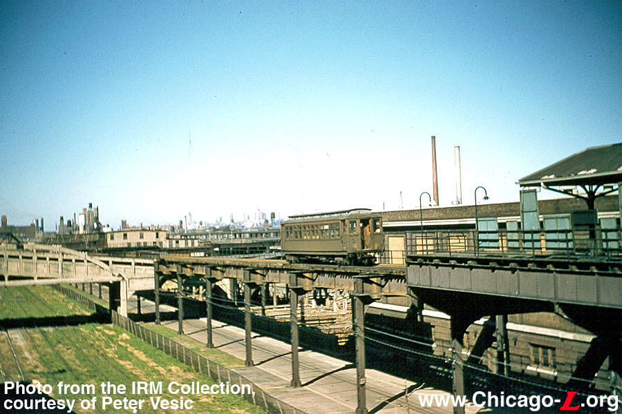
Photographer Richard H. Young took this picture of North Shore Line car 157 at the Milwaukee Terminal on June 16, 1962 during a fantrip. It must have been taken at nearly the exact same time as a photo we ran some time ago, which was somewhat controversial, and shows the same scene from a different angle, with the Milwaukee Road train shed off in the distance, behind car 157.

The same location today.

The other slide, also from the same June 16, 1962 fantrip.

Looking east along Clybourn today.
Most of today’s post is by guest author and historian Larry Sakar, who takes us on a journey following the North Shore Line interurban’s former path through Milwaukee. We hope that you will enjoy it.
Larry is the author of Speedrail: Milwaukee’s Last Rapid Transit? published in 1991 by Interurbans Press. Used copies are available through Amazon and other booksellers.
Larry was inspired, in part, by some of the Milwaukee photos we ran in our recent post Trick or Treat (October 31 2021). We will have more such pictures in future posts.
-David Sadowski
PS- You might also like our Trolley Dodger Facebook auxiliary, a private group that now has 596 members.
Auction for Rare North Shore Line Ticket Cabinet From Dempster Street Station, Skokie


FYI, much as I would like to think otherwise, you can’t keep everything. And thus I have reluctantly decided to part with the original North Shore Line ticket cabinet from the Dempster Street Station in Skokie, which was willed to me earlier this year by my late friend Jeffrey L. Wien. The proceeds will help to underwrite the cost of the Trolley Dodger blog.
The auction ends the evening of Saturday, November 20th. Full details are here:
https://www.ebay.com/itm/125004938263
Milwaukee Then and Now by Larry Sakar

From sometime in 1920 until January 21 1963, the downtown (main) station of the Chicago North Shore & Milwaukee Railroad was on the southeast corner of North 6th and West Sycamore Streets. In the 1930 renaming of Milwaukee streets West Sycamore became West Michigan Streets. The first photo shows a train laying over at the station in the evening. Date and photographer unknown.

After the North Shore Line abandoned operations on January 21 1963, the former station sat vacant until late May into early June 1964 when it was razed to make way for another downtown Milwaukee parking lot. This Tom Manz aerial photo shows the southwest corner of track 1 or where track 1 used to be. You are looking west at the intersection of North 6th Street and West Clybourn Street. Note the start of the 6th Street viaduct at bottom left. The overhead catenary bridges stood for many years post-abandonment. West Clybourn Avenue continues across the intersection with North 6th Street. The angled street seen branching odd immediately left of Clybourn Avenue is the start of West Saint Paul Ave. In North Shore’s day Saint Paul Avenue did not go east of North 6th Street, nor did it cross beneath the 6th Street viaduct. The street that is today Saint Paul Avenue east of North 6th Street was known as West Fowler Street in North Shore Line’s day and contained nothing but warehouses. Saint Paul Avenue continued east of North 6th Street starting in 1965 when the new Milwaukee Road passenger station opened on now West Saint Paul Avenue and North 5th Street. Today it has become the Milwaukee Intermodal station serving Amtrak and several bus lines. Today (2021) the site of the Milwaukee North Shore line Station is occupied by Secura Insurance Company.

North Shore trains leaving the 6th & Michigan Streets Milwaukee station cut across the intersection of North 6th Street and West Clybourn Avenue, made a curve to the left and entered the north approach to the 6th Street viaduct. There are four viaducts across the Menomonee River Valley in Milwaukee. All of them run north-south. They are 6th Street, 16th Street, 27th Street, and 35th Street. The North Shore line had exclusive access to the 6th Street viaduct. North Shore Line’s competitor The Milwaukee Electric Railway and Light Company operated streetcars over both the 16th and 27th Street viaducts. The 35th Street viaduct was the last of the four to be built. The Route 35 streetcar line ended at West Mount Vernon Avenue and did not cross the viaduct. After Route 35 was converted to Trackless trolley wire was erected and trolleybuses ran across the viaduct. Today Route 35 diesel buses of the Milwaukee County Transit System operate across all four viaducts. Post-NSL abandonment the North Shore Line’s rails remained intact but the overhead catenary bridges were removed in later years. The condition of the bridge in the 1990s had become so bad that buses and trucks were banned. Traffic was confined to the inner two lanes. Pieces of the 6th Street viaduct were actually falling off. (1951 Don Ross Photo)

The 6th Street viaduct was torn down in 2000. The scrappers nwere selling sections of North Shore Line rail to anyone willing to pay their exorbitant asking price. It has been rebuilt into two separate bridges which meet at ground level at West Canal Street. The decision to make it into two bridges which meet at Canal Street was likely influenced by the opening of the Potawatomi Hotel and Bingo Casino at North 17th and West Canal Streets. (Christopher N. Barney Photo)

North Shore Line tracks on the 6th St. viaduct. (1989 Christopher N. Barney Photo)

North Shore Line trains continued south on South 6th Street until West Scott Street. Here they made a left turn and followed West Scott Street south for one block on a curvy part of the right-of-way for one block east to South Fifth Street where they turned right onto South Fifth Street. Their next stop was West Greenfield Avenue.

The city of Milwaukee or the county (I’m not sure which) purchased that one block. Today southbound traffic on South 6th Street turns onto what is left of that one block and makes the nearly identical turn to get to West Greenfield Avenue which is the first ramp to southbound Interstate Highway 94 south of downtown Milwaukee. The former factory seen in many photos of North Shore Line trains at this location still stands and is in use for low income housing. (Christopher N. Barney Photo)

As our train continues plodding along on South Fifth Street we pass West Chase Avenue. where we see this rather odd shaped building. In the days of the North Shore Line, South 5th Street was a beautiful south side neighborhood all the way south to West Harrison Avenue. When the I-94 freeway was built every home and business along the east side of South Fifth Street was torn down to accommodate the expressway on and off ramps. Several homes and businesses on the street’s west side also suffered the same fate. (1955 Don Ross Photo)

The same location in 2016. A Chris Barney Photo.

At South Fifth and West Mitchell Streets we stop to pick-up passengers on the northwest corner. Our train passes Notre Dame Catholic High School and Saint Stanislaus Church. (Frank Butts Photo, January 1963)

Notre Dame Catholic High School and Saint Stanislaus Church are still there today, and look just as they did in North Shore’s day. The automobiles are different, but nothing remains to show that North Shore Line trains once stopped here. (Christopher N. Barney Photo)
Let’s begin the rest of our southbound trip on the North Shore Line at Harrison Avenue (the NSL called it Harrison Street). Harrison Avenue marked the end of street running and the start of the private right-of-way. The Harrison Street shops building and yards sat along the east side of the property.
After the North Shore Line was abandoned in 1963, the track and wire was removed but the building remained standing. As the years went by its appearance worsened. All of the windows had the glass removed and were boarded up. But the front of the building continued to display its heritage. Above the door that opened into the shops was the original stone letterboard which said Chicago and Milwaukee Electric Railway 1908. According to TWERHS president Chuck Westerman, TWERHS obtained the letterboard and brought it with them when they moved out to East Troy in 1972. (This was the original East Troy Trolley Museum.) While lifting it to be moved one day it was accidentally dropped and shattered into pieces.
I vividly recall coming home from school one day in 1968. I would always read the Milwaukee Journal before dinner. The “Journal” as we called it for short was Milwaukee’s evening newspaper.
On the editorial page was a drawing of a decrepit looking building with the caption (as best I can recall) that read North Shore Line shops. The editorial urged the demolition of the building because it was located directly above Interstate 94. Southbound drivers did not see it because the highway is sort of “tucked-in” beneath a cement retaining wall. However, northbound drivers got a full view. The editorial said that this gave a bad impression to anyone coming into Milwaukee on I94 from the south.
Up to that point, I was not aware that the Harrison shops building was still standing. Armed with that information I went there that weekend. The building looked every bit as bad as the editorial cartoon had depicted it. The former right-of-way was just bare ground. There wasn’t a trace of any of the tracks that had been there.
The building was torn down but I don’t know when. If you looked in a Milwaukee City Directory from 1963 on, the shops complex was not even listed. It was as if it had vanished into thin air. I had expected the address to be listed with “Vacant” shown after.
In 2017 the former Harrison Street shops property was redeveloped into Saint Augustine’s Academy, a Christian college preparatory school complete with stadium and playing field. Chris Barney, who took the present day pictures, thought the shops were on the southbound side of the right-of-way and did not take any pictures of the stadium and playing field which now occupies the site of the Harrison Street shops.


Notice the houses in the background. You see the corner of the school in the left corner (upper corner) of Chris’ photo. Now look to the right just slightly and on the northwest corner of 5th & Harrison you see a house with a window kind of dead center in the upper story. Also note the row of houses along S. 5th on the right side of the picture. Now look at the shots of the Electroliner arriving at 5th & Harrison before it. Every one of those houses, including the one on the northwest corner is still there. The only thing besides the shops that isn’t was that one story building on the right with cars parked against it. It was some sort of machine shop but I don’t think it was related to the North Shore Line. Those houses may not be there for much longer. The school is proposing to buy that entire block of S. 5th for one block north of Harrison Avenue. They want to construct a quad with a movie theater, an athletic building and other amenities for their students. The proposal including drawings of what it might look like appeared in the Milwaukee Journal about two or so months ago.
Next Stop: Oklahoma Avenue
For many years, TMER&L’s Route 16 streetcar line South 6th Street operated between North 60th and West Vliet Streets, all the way across town, via various routings. From downtown Milwaukee south, TM streetcars operated out of the downtown area via various streets to North Third Street and West Plankinton Avenue.
Here they turned south on and followed Plankinton Avenue, which becomes south Second Street after crossing the Menomonee River. Second Street was used as far as West Greenfield Avenue, where cars turned left and went one block east to South First Street. Another right turn took Route 16 streetcars to the intersection of S. Kinnickinnic Avenue and West Mitchell Streets.
This was and to this day is the location of MCTS’ (then TM’s) Kinnickinnic Avenue car [now bus] station. Streetcars turned west on West Mitchell Street and traveled west to its intersection with South Sixth Street. Cars turned left (southbound) and ran on South Sixth Street (South First Avenue before 1930) to West Euclid Street, where they turned west to South Ninth Place to reach the end of the line at West Morgan Avenue.
The “convoluted” route out of downtown Milwaukee was due to one factor- The North Shore Line. The 6th Street viaduct across the Menomonee River Valley was the exclusive property of the Chicago and Milwaukee Electric Railway and was used by both southbound and northbound North Shore Line interurbans, as well as the Birney cars and later St. Louis-built 350 series city cars on North Shore’s beloved “Nickel Dinky Line.”
TM streetcars had South Sixth Street all to themselves from West Mitchell Street south, because the North Shore’s cars operated on South Fifth Street. After getting onto the private right-of-way at Harrison Street the North Shore cars ran on an embankment high above South Sixth Street.
The “Dinky Line” ended at West Oklahoma Avenue, then traveled one block farther south to West Euclid Avenue, where they changed ends and laid over at a tiny platform just north of the Oklahoma Avenue crossing. It’s hard to believe that anyone would hike up the steep stairs from Sixth Street to the platform, but they did, many after walking blocks out of their way just to save five cents. TM streetcar fare was ten cents vs. the “Dinky” line which was a nickel. South side Milwaukeeans were notoriously frugal!
Today South Sixth Street and West Oklahoma Avenue is the one spot on the abandoned North Shore right of way that shows a hint on what used to be here.
A list of the ways in which the North Shore’s “Nickel Dinky Line” beat TM’s Route 16 streetcar line:
1. The “Dinky Line” was faster. TM streetcars on Route 16 had to stop every two blocks. The “Dinky Line” stopped only at major intersections, i.e. Fifth and Mitchell, Fifth and Greenfield and Fifth and National.
2. Between Harrison Avenue and Sixth and Oklahoma, the “Dinky” was on private right-of-way.
3. The North Shore “Dinky Line’s fare was a nickel for its entire life. TMER&L was steadily increasing fares.
4. The North Shore “Dinky Line” only crossed two short bridges on the Sixth Street viaduct. The one nearest the Sixth and Clybourn Streets end of the NSL station was over the Menomonee River, and the other just past W. Canal Street, (which as the name implies was the Menomonee River canal) a branch off the river. TM streetcars had to contend with crossings of the Milwaukee River, the Menomonee River and the Kinnickinnic River.6th & Oklahoma in the 1940s. (Don Ross Photo)
The remains of the abandoned right-of-way at 6th and Oklahoma. (Christopher N. Barney Photo)


The End of the North Shore Line Right-of-Way
Continuing south on the private right-of-way above South Sixth Street, North Shore Line trains crossed over West Holt Avenue. In addition, the Milwaukee Road trains coming out of downtown Milwaukee and heading for points south such as Chicago or Bensenville crossed at grade. I do not have any pictures of that area.
After the North Shore Line was abandoned in 1963, the area saw a significant change in 1965. West of South Sixth Street, Holt Avenue was connected to West Morgan Avenue at South Ninth Street. This was done to expedite traffic heading to the entrance ramp to either southbound or northbound Interstate Highway 94.
The Milwaukee Road was grade separated by a long bridge across South Sixth Street. Seeking to take advantage of this, The Milwaukee and Suburban Transport Company (aka “The Transport Company ”) added a “Park ‘n’ Ride lot along the east side of the abandoned North Shore Line right-of-way. This lot is for riders on Bus Route 40- the Holt-College Freeway Flyer line.
Buses do not enter the parking lot, but stop on a bus-only section of the off ramp to pick-up or discharge passengers. As best as I have been able to tell, this ramp occupies at least part, if not all of the North Shore line’s northbound track. This could easily have been transformed into a Rapid Transit line between Mitchell International Airport and downtown Milwaukee.
Just before the abandoned right-of-way gets to its present day end at West Bolivar Avenue, it passes through what was once the Sixth Street cut. The cut began at West Howard Avenue and continued south to TMER & L’s Rapid Transit Line to Hales Corners at Greenwood Junction Lakeside Belt Line, which carried coal from Powereton Junction (approximately South 13th Street and West Waterford Avenue) to the Lakeside Power Plant.
This was strictly a freight line except for a 1939 CERA fan trip, which operated over it all the way west to the connection with TM’s Hales Corners Rapid Transit line at Greenwood Junction (South 100th Street one block south of West Howard Avenue.
North Shore trains emerged from the cut after crossing beneath West Waterford Avenue. CERA Bulletin 107, Route of the Electroliners states that the cut was three miles long. That is incorrect. It was three blocks long. The cut was filled in by the city of Milwaukee in March 1989. This area had once been the Town of Lake.
The tall, round tower seen across South Sixth Street is the former Town of Lake water tower which no longer holds water. The tower has been used for all sorts of things since being replaced by the water treatment plant almost next to its north face on the southwest corner of South Sixth Street and West Howard Avenue.
One additional piece of information that may be of interest to Trolley Dodger readers. You can now purchase a garden plot on the filled-in 6th Street cut and grow what you line. Quite a few people seem to have done just that. I do not know what it costs.
Finally, we come to the end of the North Shore Line’s abandoned right-of-way within the city of Milwaukee at West Bolivar Avenue. The high embankment ends suddenly and goes no further south. This is where present day I-94 coming from downtown and heading west to the Mitchell Interchange crosses over South 6th Street.
From the south side of I-94 south, the right-of-way is completely gone. The land is occupied by restaurants, hotels from the former crossing of West Layton Avenue to the Airport Business Park. If you weren’t previously aware of the wonderful interurban line that passed this way you would never know it now.
No trace of the North Shore exists anywhere south of this point, except for a tiny spot where it crossed beneath the intersection of South Howell and West Rawson Avenues. I end with a Then and Now view at Howell and Rawson. Post-abandonment the bridges above the NSL were removed and the grades of both streets lowered.
In case you might be wondering, the abandoned NSL right-of-way is posted in spots ‘NO TRESPASSING PROPERTY OF MILWAUKEE COUNTY EXPRESSWAY COMMISSION.”
A North Shore Line two-car train is southbound in the 6th Street cut at Norwich Ave. (Bob Genack Photo)
The Old Town of Lake water tower at S. 6th & W. Norwich in 1989 (Christopher N. Barney Photo)
North Shore Line 749 and three others, northbound at Bolivar Avenue in 1955. (Don Ross Photo)
The abandoned North Shore Line right-of-way at West Bolivar Ave. This is where the abandoned right-of-way now comes to an abrupt end within the city limits of Milwaukee.
North Shore Line 758 is northbound at Howell and Rawson in 1955. (Don Ross Photo)
Howell and Rawson, looking south on Howell (present day) (Christopher N. Barney Photo)
Howell and Rawson, looking southeast (present day) (Christopher N. Barney Photo)


Postscript
I thought you’d enjoy these two NSL pics. The first one is what we’ve been discussing about TM and NSL competing at 6th and Oklahoma. You have an 800-series car on TM route 16 northbound, and a Birney up on the embankment laying over ready to return to downtown Milwaukee. I don’t know who took it. The fact that the NSL car is a Birney and because you have a streetcar on Route 16 places this picture sometime before July 1947.
The second photo shows one of the “Liners” at full speed one block farther south at 6th and Euclid. It is southbound passing the Heil Company. Heil made things like garbage trucks and other types of municipal vehicles. The building is still there, next to the abandoned right-of-way, but the Heil Company is gone. The building now houses corporate offices for Aurora Health Care. If you look to the left, you get a pretty good idea of just how high up that right-of-way was above South Sixth Street. Don Ross took this picture. He must have had someone holding on to him because a “Liner” coming past you at full speed would have tossed you down to 6th Street. I don’t think I’d have ever tried anything like this!
-Larry Sakar


Thanks, Larry! Keep those cards and letters coming in, folks!
-David Sadowski
Recent Finds

CTA PCC 7202 is southbound on Clark Street near 15th Street and the St. Charles Air Line, possibly around 1956.

CTA PCCs 7195 and 7180 at 81st and Halsted, south end of Route 22, possibly circa 1956.

CTA PCCs 7175 and 7160 at 81st and Halsted.

CTA red Pullman 863 is northbound on Stony Island at 72nd Street, headed towards Navy Pier. Stuart B. Slaymaker: “Big Kaiser-Frazer dealer in the right background.”

This picture of Milwaukee trolley buses was taken in March 1964. Here’s what Larry Sakar says about it: “I know exactly what this is and where. After the last trolley buses ended service on June 30,1965, The Transport Company (The Milwaukee Suburban Transport Corp.) moved all of them (if not all then a lot of them) to Cold Spring shops. M&STC made a deal to sell them to Mexico City which is where they ended up. What you see here is one of them being brought down to lower Cold Spring where TM (M&STC’s predecessor) had a connection directly to the Milwaukee Road. According to Russ Schultz, whom I consider to be the leading authority on Milwaukee trolley buses and Dave Stanley also, M&STC sold 50 Marmon-Herrington trolley buses to Mexico City on February 10, 1964. That was the first batch. In 1967 M&STC sold 51 additional Marmons to Mexico City and according to Russ they were shipped in August and September of that year.”
Chicago’s Lost “L”s Online Presentation

We recently gave an online presentation about our book Chicago’s Lost “L”s for the Chicago Public Library, as part of their One Book, One Chicago series. You can watch it online by following this link.
The Trolley Dodger On the Air

We appeared on the Dave Plier Show on WGN radio on July 16, 2021, to discuss Chicago’s Lost “L”s. You can hear that discussion here.
Our Latest Book, Now Available:
Chicago’s Lost “L”s

From the back cover:
Chicago’s system of elevated railways, known locally as the “L,” has run continuously since 1892 and, like the city, has never stood still. It helped neighborhoods grow, brought their increasingly diverse populations together, and gave the famous Loop its name. But today’s system has changed radically over the years. Chicago’s Lost “L”s tells the story of former lines such as Garfield Park, Humboldt Park, Kenwood, Stockyards, Normal Park, Westchester, and Niles Center. It was once possible to take high-speed trains on the L directly to Aurora, Elgin, and Milwaukee, Wisconsin. The L started out as four different companies, two starting out using steam engines instead of electricity. Eventually, all four came together via the Union Loop. The L is more than a way of getting around. Its trains are a place where people meet and interact. Some say the best way to experience the city is via the L, with its second-story view. Chicago’s Lost “L”s is virtually a “secret history” of Chicago, and this is your ticket. David Sadowski grew up riding the L all over the city. He is the author of Chicago Trolleys and Building Chicago’s Subways and runs the online Trolley Dodger blog.
The Images of America series celebrates the history of neighborhoods, towns, and cities across the country. Using archival photographs, each title presents the distinctive stories from the past that shape the character of the community today. Arcadia is proud to play a part in the preservation of local heritage, making history available to all.
Title Chicago’s Lost “L”s
Images of America
Author David Sadowski
Edition illustrated
Publisher Arcadia Publishing (SC), 2021
ISBN 1467100007, 9781467100007
Length 128 pages
Chapters:
01. The South Side “L”
02. The Lake Street “L”
03. The Metropolitan “L”
04. The Northwestern “L”
05. The Union Loop
06. Lost Equipment
07. Lost Interurbans
08. Lost Terminals
09. Lost… and Found
Each copy purchased here will be signed by the author, and you will also receive a bonus facsimile of a 1926 Chicago Rapid Transit Company map, with interesting facts about the “L” on the reverse side.

The price of $23.99 includes shipping within the United States.
For Shipping to US Addresses:

For Shipping to Canada:
For Shipping Elsewhere:
NEW DVD:

A Tribute to the North Shore Line
To commemorate the 50th anniversary of the demise of the fabled North Shore Line interurban in January 2013, Jeffrey L. Wien and Bradley Criss made a very thorough and professional video presentation, covering the entire route between Chicago and Milwaukee and then some. Sadly, both men are gone now, but their work remains, making this video a tribute to them, as much as it is a tribute to the Chicago North Shore & Milwaukee.
Jeff drew on his own vast collections of movie films, both his own and others such as the late William C. Hoffman, wrote and gave the narration. Bradley acted as video editor, and added authentic sound effects from archival recordings of the North Shore Line.
It was always Jeff’s intention to make this video available to the public, but unfortunately, this did not happen in his lifetime. Now, as the caretakers of Jeff’s railfan legacy, we are proud to offer this excellent two-hour program to you for the first time. The result is a fitting tribute to what Jeff called his “Perpetual Adoration,” which was the name of a stop on the interurban.
Jeff was a wholehearted supporter of our activities, and the proceeds from the sale of this disc will help defray some of the expenses of keeping the Trolley Dodger web site going.
Total time – 121:22
# of Discs – 1
Price: $19.99 (Includes shipping within the United States)
Help Support The Trolley Dodger
This is our 281st post, and we are gradually creating a body of work and an online resource for the benefit of all railfans, everywhere. To date, we have received over 822,000 page views, for which we are very grateful.
You can help us continue our original transit research by checking out the fine products in our Online Store.
As we have said before, “If you buy here, we will be here.”
We thank you for your support.
DONATIONS
In order to continue giving you the kinds of historic railroad images that you have come to expect from The Trolley Dodger, we need your help and support. It costs money to maintain this website, and to do the sort of historic research that is our specialty.
Your financial contributions help make this web site better, and are greatly appreciated.


